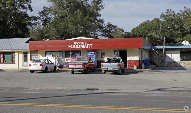
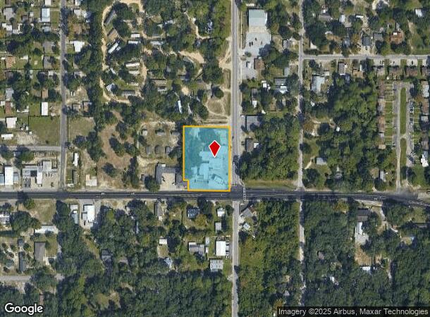
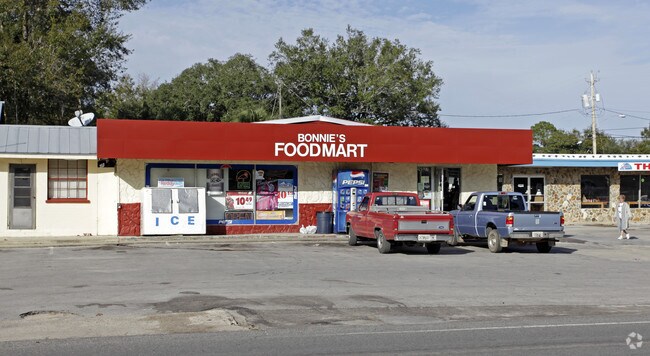
Property Record
822 S Highway 22 A, Panama City, FL 32404
NEARBY LISTINGS FOR SALE OR LEASE
Property Detail
822 S Highway 22 A
24971-000-000
13 4S 14W-44-119A3 BEG 33 N & 40 W OF SE COR OF SW1/4 TH W 179.5 N 52 W 22 N 258 E 201.5 S 310 TO POB ORB 678 P 316 ORB 3442 P 781
Storesoffices
Bay
X
Florida
12005C0363J
1.52 AC
2023
Panama City
2024
Other Market Areas
000900
Panama City, FL
5,962 SF
DEMOGRAPHICS near 822 S Highway 22 A
1 Mile
3 Mile
5 Mile
2024 Total Population
4,803
28,970
45,632
2029 Population
5,076
31,113
49,427
Pop Growth 2024-2029
+ 5.68%
+ 7.40%
+ 8.32%
Average Age
42
39
39
2024 Total Households
1,930
11,044
17,294
HH Growth 2024-2029
+ 6.32%
+ 7.95%
+ 8.72%
Median Household Inc
$58,592
$52,555
$51,203
Avg Household Size
2.50
2.60
2.50
2024 Avg HH Vehicles
2.00
2.00
2.00
Median Home Value
$156,412
$164,057
$163,766
Median Year Built
1981
1982
1984
Nearby Places
Map Layers
Map Styles
 Street
 Aerial
- Restaurants
- Banks
- Shops
- Fitness
- Groceries
PUBLIC TRANSPORTATION
AIRPORT
Northwest Florida Beaches International
DRIVE
WALK
Distance
Northwest Florida Beaches International
44 min
28.0 mi
Freight Ports
Port of Panama City
DRIVE
WALK
Distance
Port of Panama City
22 min
11.3 mi
Nearby Properties
Address
Land Use
TOTAL SIZE
Lot Size
Zoning
Address
Land Use
TOTAL SIZE
Lot Size
Zoning
650 AC
BC14
Address
Land Use
TOTAL SIZE
Lot Size
Zoning
305,058 SF
16.18 AC
Address
Land Use
TOTAL SIZE
Lot Size
Zoning
226,068 SF
12.80 AC
Address
Land Use
TOTAL SIZE
Lot Size
Zoning
263,872 SF
41.43 AC
PC12
Address
Land Use
TOTAL SIZE
Lot Size
Zoning
415,651 SF
266 AC
BC13
Address
Land Use
TOTAL SIZE
Lot Size
Zoning
424,813 SF
30 AC
Address
Land Use
TOTAL SIZE
Lot Size
Zoning
143,208 SF
5.45 AC
Address
Land Use
TOTAL SIZE
Lot Size
Zoning
107,778 SF
10 AC
Address
Land Use
TOTAL SIZE
Lot Size
Zoning
38,860 SF
4.32 AC
Address
Land Use
TOTAL SIZE
Lot Size
Zoning
181,571 SF
22.29 AC
CLWY04
Address
Land Use
TOTAL SIZE
Lot Size
Zoning
39,628 SF
4.45 AC
CLWY04
Address
Land Use
TOTAL SIZE
Lot Size
Zoning
46,368 SF
2.30 AC
CLWY23
Address
Land Use
TOTAL SIZE
Lot Size
Zoning
40,264 SF
2 AC
CLWY04
Address
Land Use
TOTAL SIZE
Lot Size
Zoning
43,110 SF
2.54 AC
PC09
Address
Land Use
TOTAL SIZE
Lot Size
Zoning
55,300 SF
10.91 AC
PC12
Address
Land Use
TOTAL SIZE
Lot Size
Zoning
68,401 SF
30 AC
Address
Land Use
TOTAL SIZE
Lot Size
Zoning
42,456 SF
3.90 AC
CLWY04
Address
Land Use
TOTAL SIZE
Lot Size
Zoning
45,403 SF
2.65 AC
CLWY04
Address
Land Use
TOTAL SIZE
Lot Size
Zoning
67,478 SF
12.40 AC
PC14
Address
Land Use
TOTAL SIZE
Lot Size
Zoning
48,576 SF
5.20 AC
CLWY23
Address
Land Use
TOTAL SIZE
Lot Size
Zoning
43,530 SF
10.70 AC
PC11
Address
Land Use
TOTAL SIZE
Lot Size
Zoning
128,098 SF
0.10 AC
Address
Land Use
TOTAL SIZE
Lot Size
Zoning
118,902 SF
33.66 AC
BC13
Address
Land Use
TOTAL SIZE
Lot Size
Zoning
70,028 SF
6.64 AC
CLWY04
Address
Land Use
TOTAL SIZE
Lot Size
Zoning
90,684 SF
15.59 AC
CLWY08
Address
Land Use
TOTAL SIZE
Lot Size
Zoning
Address
Land Use
TOTAL SIZE
Lot Size
Zoning
29,620 SF
8.64 AC
CLWY04
Address
Land Use
TOTAL SIZE
Lot Size
Zoning
38,784 SF
4.50 AC
CLWY23
Address
Land Use
TOTAL SIZE
Lot Size
Zoning
4,524 SF
16.84 AC
PC12
Address
Land Use
TOTAL SIZE
Lot Size
Zoning
54,628 SF
3.43 AC
CLWY04
The World's #1 Commercial Real Estate Marketplace
Connect with us
© 2025 CoStar Group
The information above has been obtained from sources believed reliable. While we do not doubt its accuracy we have not verified it and make no guarantee, warranty or representation about it. It is your responsibility to independently confirm its accuracy and completeness. Any projections, opinions, assumptions, or estimates used are for example only and do not represent the current or future performance of the property. The value of this transaction to you depends on tax and other factors which should be evaluated by your tax, financial, and legal advisors. You and your advisors should conduct a careful, independent investigation of the property to determine to your satisfaction the suitability of the property for your needs.