Property Record
8220 Eustis Hunt Rd, Spanaway, WA 98387
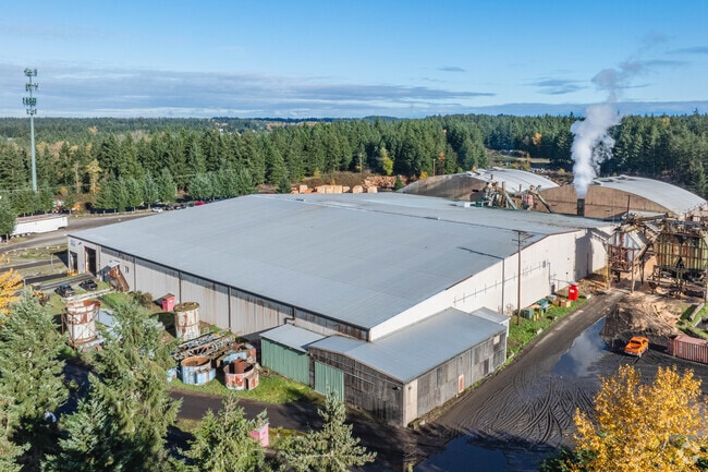

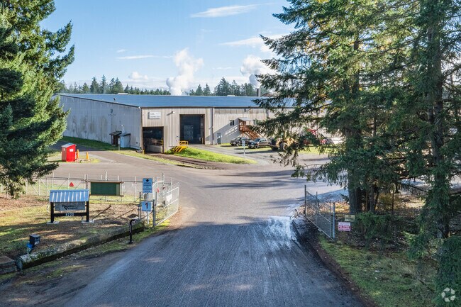
Property Detail
8220 Eustis Hunt Rd
041808-1013
SECTION 08 TOWNSHIP 18 RANGE 04 QUARTER 14 : THAT POR OF E 1/2 OF NE SEC 8 LY S OF EUSTIS-HUNT CO RD AND NELY OF T E RR R/W ALSO THAT POR OF E 1/2 OF NE LY BETWEEN EUSTIS-HUNT CO RD AND PUYALLUP-GRAHAM CO RD TOG/W THAT POR OF R/W VAC PER ORD 2003-35
Lumberyard
Pierce
R5
Washington
C and X Area of minimal flood hazard, usually depicted on FIRMs as above the 500-year flood level.
32.29 AC
2024
Parkland/Spanaway
2025
Seattle/Puget Sound
073124
Seattle-Tacoma-Bellevue, WA
143,895 SF
NEARBY LISTINGS FOR SALE OR LEASE
DEMOGRAPHICS near 8220 Eustis Hunt Rd
1 mile
3 mile
5 mile
2025 Total Population
6,838
57,079
133,431
2030 Population
6,834
57,554
135,117
Pop Growth 2025-2030
(0.06%)
+ 0.83%
+ 1.26%
Average Age
37
37
37
2025 Total Households
2,138
18,219
43,287
HH Growth 2025-2030
0.00%
+ 0.82%
+ 1.28%
Median Household Inc
$118,851
$114,392
$113,491
Avg Household Size
3.10
3.00
3.00
2025 Avg HH Vehicles
3.00
2.00
2.00
Median Home Value
$481,497
$491,140
$499,100
Median Year Built
1996
1999
1999
Nearby Places
Map Layers
Map Styles
 Street
 Aerial
Layers
 Traffic
 Biking
Places
Listings with unknown addresses are not visible on the map
- Restaurants
- Banks
- Shops
- Fitness
- Groceries
PUBLIC TRANSPORTATION
AIRPORT
Seattle-Tacoma International
Drive
Walk
Distance
Seattle-Tacoma International
58 min
34.5 mi
Freight Ports
Port of Tacoma
Drive
Walk
Distance
Port of Tacoma
32 min
17.2 mi
Nearby Properties
Address
Land Use
TOTAL SIZE
Lot Size
Zoning
Address
Land Use
TOTAL SIZE
Lot Size
Zoning
1,381,439 SF
209.68 AC
EC
Address
Land Use
TOTAL SIZE
Lot Size
Zoning
492,365 SF
24.33 AC
EC
Address
Land Use
TOTAL SIZE
Lot Size
Zoning
1,110,154 SF
53.99 AC
EC
Address
Land Use
TOTAL SIZE
Lot Size
Zoning
782,773 SF
53.33 AC
Address
Land Use
TOTAL SIZE
Lot Size
Zoning
77,520 SF
25 AC
EC
Address
Land Use
TOTAL SIZE
Lot Size
Zoning
753,069 SF
40.94 AC
Address
Land Use
TOTAL SIZE
Lot Size
Zoning
1,118,480 SF
75.62 AC
Address
Land Use
TOTAL SIZE
Lot Size
Zoning
611,206 SF
30.76 AC
Address
Land Use
TOTAL SIZE
Lot Size
Zoning
305,680 SF
14.48 AC
Address
Land Use
TOTAL SIZE
Lot Size
Zoning
645,993 SF
62.57 AC
EC
Address
Land Use
TOTAL SIZE
Lot Size
Zoning
352,930 SF
20.68 AC
Address
Land Use
TOTAL SIZE
Lot Size
Zoning
153,138 SF
9.11 AC
CC
Address
Land Use
TOTAL SIZE
Lot Size
Zoning
312,225 SF
13.66 AC
EC
Address
Land Use
TOTAL SIZE
Lot Size
Zoning
218,262 SF
3.58 AC
MUD
Address
Land Use
TOTAL SIZE
Lot Size
Zoning
192,163 SF
24.26 AC
EC
Address
Land Use
TOTAL SIZE
Lot Size
Zoning
241,111 SF
16.67 AC
R10
Address
Land Use
TOTAL SIZE
Lot Size
Zoning
300,942 SF
18.82 AC
EC
Address
Land Use
TOTAL SIZE
Lot Size
Zoning
313,278 SF
57.62 AC
R5
Address
Land Use
TOTAL SIZE
Lot Size
Zoning
171,185 SF
15.32 AC
EC
Address
Land Use
TOTAL SIZE
Lot Size
Zoning
311,452 SF
18.90 AC
EC
Address
Land Use
TOTAL SIZE
Lot Size
Zoning
267,365 SF
13.10 AC
EC
Address
Land Use
TOTAL SIZE
Lot Size
Zoning
281,181 SF
18.67 AC
EC
Address
Land Use
TOTAL SIZE
Lot Size
Zoning
105,592 SF
11.39 AC
ECOR
Address
Land Use
TOTAL SIZE
Lot Size
Zoning
9,846 SF
42.52 AC
Address
Land Use
TOTAL SIZE
Lot Size
Zoning
181,241 SF
34.50 AC
EC
Address
Land Use
TOTAL SIZE
Lot Size
Zoning
375,000 SF
26.29 AC
EC
Address
Land Use
TOTAL SIZE
Lot Size
Zoning
1 SF
3.56 AC
EC
Address
Land Use
TOTAL SIZE
Lot Size
Zoning
1 SF
3.54 AC
EC
Address
Land Use
TOTAL SIZE
Lot Size
Zoning
229,493 SF
10.72 AC
Address
Land Use
TOTAL SIZE
Lot Size
Zoning
175,873 SF
19.15 AC
UCOR
The World's #1 Commercial Real Estate Marketplace
Connect with us
© 2026 CoStar Group
The information above has been obtained from sources believed reliable. While we do not doubt its accuracy we have not verified it and make no guarantee, warranty or representation about it. It is your responsibility to independently confirm its accuracy and completeness. Any projections, opinions, assumptions, or estimates used are for example only and do not represent the current or future performance of the property. The value of this transaction to you depends on tax and other factors which should be evaluated by your tax, financial, and legal advisors. You and your advisors should conduct a careful, independent investigation of the property to determine to your satisfaction the suitability of the property for your needs.