Property Record
8220 Palladay Rd, Elverta, CA 95626
NEARBY LISTINGS FOR SALE OR LEASE
Property Detail
8220 Palladay Rd
Sacramento-Roseville-Folsom, CA
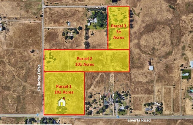
Parcel Map
202-0080-058
PARCEL MAP, LOT C
Recreationalacreage
Sacramento
X
California
06061C1005H
c
2024
5 AC
2025
Rio Linda/N Highlands
007206
Sacramento
2,367 SF
DEMOGRAPHICS near 8220 Palladay Rd
1 Mile
3 Mile
5 Mile
2024 Total Population
1,078
26,045
129,480
2029 Population
1,062
25,931
130,759
Pop Growth 2024-2029
(1.48%)
(0.44%)
+ 0.99%
Average Age
42
39
37
2024 Total Households
356
8,182
40,973
HH Growth 2024-2029
(1.69%)
(0.49%)
+ 1.02%
Median Household Inc
$90,988
$88,306
$83,885
Avg Household Size
3.00
3.10
3.10
2024 Avg HH Vehicles
3.00
2.00
2.00
Median Home Value
$564,516
$456,988
$430,512
Median Year Built
1980
1980
1986
Nearby Places
Map Layers
Map Styles
 Street
 Aerial
- Restaurants
- Banks
- Shops
- Fitness
- Groceries
PUBLIC TRANSPORTATION
AIRPORT
Sacramento International
DRIVE
WALK
Distance
Sacramento International
22 min
13.4 mi
Freight Ports
Port of Stockton
DRIVE
WALK
Distance
Port of Stockton
75 min
61.9 mi
SALE & LEASE HISTORY
LISTING DATE
SALE/LEASE

Oct 24, 2019
For Sale
Nearby Properties
Address
Land Use
TOTAL SIZE
Lot Size
Zoning
Address
Land Use
TOTAL SIZE
Lot Size
Zoning
124,819 SF
13.10 AC
SC
Address
Land Use
TOTAL SIZE
Lot Size
Zoning
Address
Land Use
TOTAL SIZE
Lot Size
Zoning
53.76 AC
RD-5
Address
Land Use
TOTAL SIZE
Lot Size
Zoning
60,368 SF
3.37 AC
SC
Address
Land Use
TOTAL SIZE
Lot Size
Zoning
86,400 SF
7.17 AC
GC
Address
Land Use
TOTAL SIZE
Lot Size
Zoning
14,608 SF
1.47 AC
LC
Address
Land Use
TOTAL SIZE
Lot Size
Zoning
59,703 SF
3.61 AC
SPA
Address
Land Use
TOTAL SIZE
Lot Size
Zoning
710 SF
36.97 AC
IR
Address
Land Use
TOTAL SIZE
Lot Size
Zoning
1,752 SF
239.40 AC
SPLPVSP
Address
Land Use
TOTAL SIZE
Lot Size
Zoning
27,092 SF
5.53 AC
AR-5
Address
Land Use
TOTAL SIZE
Lot Size
Zoning
7,009 SF
0.99 AC
SC
Address
Land Use
TOTAL SIZE
Lot Size
Zoning
3,490 SF
0.69 AC
SC
Address
Land Use
TOTAL SIZE
Lot Size
Zoning
18,000 SF
4.77 AC
M-1
Address
Land Use
TOTAL SIZE
Lot Size
Zoning
29,888 SF
4.81 AC
M-1
Address
Land Use
TOTAL SIZE
Lot Size
Zoning
2,219 SF
0.52 AC
LC
Address
Land Use
TOTAL SIZE
Lot Size
Zoning
11,000 SF
0.89 AC
SC
Address
Land Use
TOTAL SIZE
Lot Size
Zoning
4,592 SF
19.10 AC
FBX
Address
Land Use
TOTAL SIZE
Lot Size
Zoning
102,750 SF
8.96 AC
GC
Address
Land Use
TOTAL SIZE
Lot Size
Zoning
69,696 SF
2.27 AC
SPA
Address
Land Use
TOTAL SIZE
Lot Size
Zoning
3,461 SF
0.27 AC
GC
Address
Land Use
TOTAL SIZE
Lot Size
Zoning
1,107 SF
4.79 AC
M-1
Address
Land Use
TOTAL SIZE
Lot Size
Zoning
2,955 SF
0.57 AC
GC
Address
Land Use
TOTAL SIZE
Lot Size
Zoning
81,342 SF
4.45 AC
SPA
Address
Land Use
TOTAL SIZE
Lot Size
Zoning
3,150 SF
0.94 AC
SC
Address
Land Use
TOTAL SIZE
Lot Size
Zoning
15,000 SF
2.17 AC
M-1
The World's #1 Commercial Real Estate Marketplace
Connect with us
© 2026 CoStar Group
The information above has been obtained from sources believed reliable. While we do not doubt its accuracy we have not verified it and make no guarantee, warranty or representation about it. It is your responsibility to independently confirm its accuracy and completeness. Any projections, opinions, assumptions, or estimates used are for example only and do not represent the current or future performance of the property. The value of this transaction to you depends on tax and other factors which should be evaluated by your tax, financial, and legal advisors. You and your advisors should conduct a careful, independent investigation of the property to determine to your satisfaction the suitability of the property for your needs.