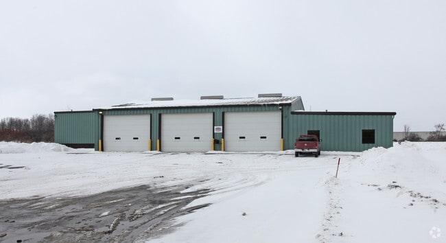
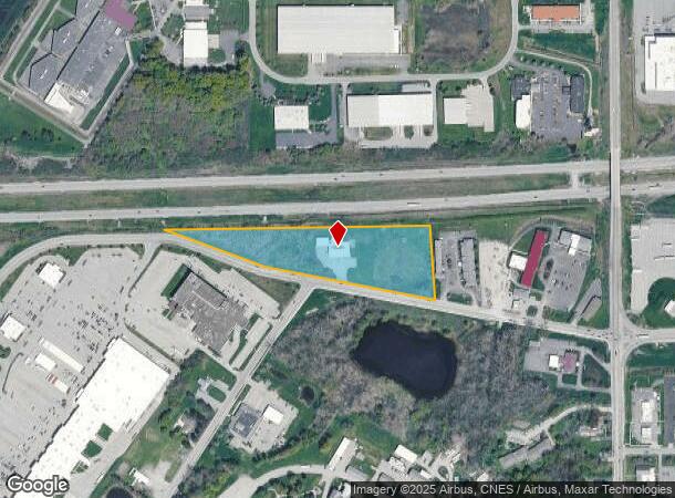
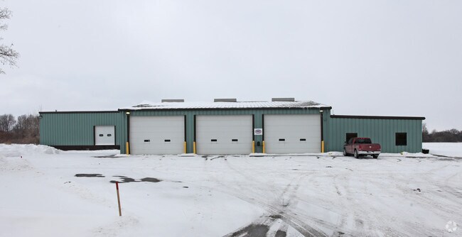
Property Record
8220 Park Rd, Batavia, NY 14020
NEARBY LISTINGS FOR SALE OR LEASE
Property Detail
8220 Park Rd
Batavia, NY
Genesee
182400-008-000-0001-053-001
New York
Coldstorage
53.001
2025
6.90 AC
2024
Rochester Other Areas
950401
Other Market Areas
9,578 SF
DEMOGRAPHICS near 8220 Park Rd
1 Mile
3 Mile
5 Mile
2024 Total Population
2,636
18,372
24,502
2029 Population
2,599
17,986
24,054
Pop Growth 2024-2029
(1.40%)
(2.10%)
(1.83%)
Average Age
45
42
42
2024 Total Households
1,066
7,998
10,466
HH Growth 2024-2029
(1.41%)
(2.11%)
(1.86%)
Median Household Inc
$64,615
$54,970
$58,031
Avg Household Size
2.20
2.10
2.20
2024 Avg HH Vehicles
2.00
2.00
2.00
Median Home Value
$136,734
$129,169
$136,226
Median Year Built
1947
1951
1953
Nearby Places
- Restaurants
- Banks
- Shops
- Fitness
- Groceries
PUBLIC TRANSPORTATION
AIRPORT
Buffalo Niagara International
DRIVE
WALK
Distance
Buffalo Niagara International
41 min
31.2 mi
Frederick Douglass/Greater Rochester International
DRIVE
WALK
Distance
Frederick Douglass/Greater Rochester International
41 min
31.6 mi
Freight Ports
Albany, NY Port
DRIVE
WALK
Distance
Albany, NY Port
293 min
251.1 mi
Nearby Properties
Address
Land Use
TOTAL SIZE
Lot Size
Zoning
Address
Land Use
TOTAL SIZE
Lot Size
Zoning
136,135 SF
44 AC
Address
Land Use
TOTAL SIZE
Lot Size
Zoning
64,890 SF
33.60 AC
Address
Land Use
TOTAL SIZE
Lot Size
Zoning
214,799 SF
34.80 AC
Address
Land Use
TOTAL SIZE
Lot Size
Zoning
147,117 SF
6.49 AC
Address
Land Use
TOTAL SIZE
Lot Size
Zoning
3.12 AC
Address
Land Use
TOTAL SIZE
Lot Size
Zoning
208,058 SF
25.70 AC
Address
Land Use
TOTAL SIZE
Lot Size
Zoning
93,900 SF
8.30 AC
C00
Address
Land Use
TOTAL SIZE
Lot Size
Zoning
156,578 SF
28.60 AC
Address
Land Use
TOTAL SIZE
Lot Size
Zoning
83,131 SF
1.40 AC
Address
Land Use
TOTAL SIZE
Lot Size
Zoning
126,835 SF
9.60 AC
Address
Land Use
TOTAL SIZE
Lot Size
Zoning
8,725 SF
14.70 AC
Address
Land Use
TOTAL SIZE
Lot Size
Zoning
102,404 SF
15.40 AC
Address
Land Use
TOTAL SIZE
Lot Size
Zoning
117,034 SF
8.40 AC
Address
Land Use
TOTAL SIZE
Lot Size
Zoning
97,450 SF
23.60 AC
Address
Land Use
TOTAL SIZE
Lot Size
Zoning
92,080 SF
3.50 AC
Address
Land Use
TOTAL SIZE
Lot Size
Zoning
643,014 SF
33.50 AC
Address
Land Use
TOTAL SIZE
Lot Size
Zoning
111,230 SF
2.70 AC
Address
Land Use
TOTAL SIZE
Lot Size
Zoning
98,577 SF
3.80 AC
Address
Land Use
TOTAL SIZE
Lot Size
Zoning
25,514 SF
11.30 AC
Address
Land Use
TOTAL SIZE
Lot Size
Zoning
76.11 AC
Address
Land Use
TOTAL SIZE
Lot Size
Zoning
9,248 SF
23.10 AC
Address
Land Use
TOTAL SIZE
Lot Size
Zoning
128,620 SF
9.82 AC
Address
Land Use
TOTAL SIZE
Lot Size
Zoning
52,732 SF
3.20 AC
Address
Land Use
TOTAL SIZE
Lot Size
Zoning
696 SF
63.20 AC
Address
Land Use
TOTAL SIZE
Lot Size
Zoning
29,795 SF
4.80 AC
Address
Land Use
TOTAL SIZE
Lot Size
Zoning
29,795 SF
4.80 AC
Address
Land Use
TOTAL SIZE
Lot Size
Zoning
147,000 SF
7 AC
Address
Land Use
TOTAL SIZE
Lot Size
Zoning
44,559 SF
27.70 AC
Address
Land Use
TOTAL SIZE
Lot Size
Zoning
79,576 SF
9.60 AC
Address
Land Use
TOTAL SIZE
Lot Size
Zoning
169,207 SF
8.70 AC
The World's #1 Commercial Real Estate Marketplace
Connect with us
© 2025 CoStar Group
The information above has been obtained from sources believed reliable. While we do not doubt its accuracy we have not verified it and make no guarantee, warranty or representation about it. It is your responsibility to independently confirm its accuracy and completeness. Any projections, opinions, assumptions, or estimates used are for example only and do not represent the current or future performance of the property. The value of this transaction to you depends on tax and other factors which should be evaluated by your tax, financial, and legal advisors. You and your advisors should conduct a careful, independent investigation of the property to determine to your satisfaction the suitability of the property for your needs.