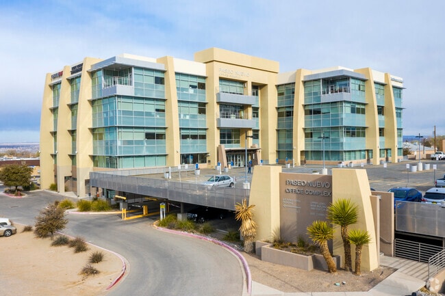
Property Record
8220 San Pedro Dr Ne, Albuquerque, NM 87113


Current Lease Availabilities
NEARBY LISTINGS FOR SALE OR LEASE
Property Detail
8220 San Pedro Dr Ne
1-018-064-291081-4-02-01
Paseo Nuevo
Professionalbldgmultistory
TR A PLAT OF TRACTS A, B, & C PASEO NUEVO CONT 3.0417 AC +/
X
Bernalillo
35001C0137H
New Mexico
2024
3.04 AC
2025
Far Northeast Heights
003722
Albuquerque
257,532 SF
Albuquerque, NM
DEMOGRAPHICS near 8220 San Pedro Dr Ne
1 Mile
3 Mile
5 Mile
2024 Total Population
10,635
66,249
168,647
2029 Population
10,623
66,093
168,523
Pop Growth 2024-2029
(0.11%)
(0.24%)
(0.07%)
Average Age
42
43
43
2024 Total Households
4,481
28,966
74,811
HH Growth 2024-2029
(0.33%)
(0.31%)
(0.10%)
Median Household Inc
$79,125
$72,046
$69,296
Avg Household Size
2.30
2.20
2.20
2024 Avg HH Vehicles
2.00
2.00
2.00
Median Home Value
$303,240
$330,264
$317,891
Median Year Built
1998
1987
1980
Nearby Places
Map Layers
Map Styles
 Street
 Aerial
- Restaurants
- Banks
- Shops
- Fitness
- Groceries
PUBLIC TRANSPORTATION
COMMUTER RAIL
Los Ranchos-Journal Center (NMRX - Rio Metro Regional Transit District, Rail Runner Express - Rio Metro Regional Transit District)
DRIVE
WALK
Distance
Los Ranchos-Journal Center (NMRX - Rio Metro Regional Transit District, Rail Runner Express - Rio Metro Regional Transit District)
7 min
3.4 mi
Sandia Pueblo Rail Runner Station (NMRX - Rio Metro Regional Transit District)
DRIVE
WALK
Distance
Sandia Pueblo Rail Runner Station (NMRX - Rio Metro Regional Transit District)
7 min
3.9 mi
AIRPORT
Albuquerque International Sunport
DRIVE
WALK
Distance
Albuquerque International Sunport
30 min
13.2 mi
Freight Ports
Tulsa Port Of Catoosa
DRIVE
WALK
Distance
Tulsa Port Of Catoosa
694 min
664.5 mi
Nearby Properties
Address
Land Use
TOTAL SIZE
Lot Size
Zoning
Address
Land Use
TOTAL SIZE
Lot Size
Zoning
2,880 SF
162.53 AC
Address
Land Use
TOTAL SIZE
Lot Size
Zoning
380,827 SF
42 AC
Address
Land Use
TOTAL SIZE
Lot Size
Zoning
17,809 SF
6.58 AC
Address
Land Use
TOTAL SIZE
Lot Size
Zoning
34,585 SF
10.16 AC
Address
Land Use
TOTAL SIZE
Lot Size
Zoning
Address
Land Use
TOTAL SIZE
Lot Size
Zoning
519,680 SF
59.70 AC
Address
Land Use
TOTAL SIZE
Lot Size
Zoning
386,293 SF
44.14 AC
Address
Land Use
TOTAL SIZE
Lot Size
Zoning
406,554 SF
31.72 AC
Address
Land Use
TOTAL SIZE
Lot Size
Zoning
59,072 SF
17.86 AC
Address
Land Use
TOTAL SIZE
Lot Size
Zoning
165,312 SF
14.86 AC
Address
Land Use
TOTAL SIZE
Lot Size
Zoning
395,175 SF
54.49 AC
Address
Land Use
TOTAL SIZE
Lot Size
Zoning
173,169 SF
45.75 AC
Address
Land Use
TOTAL SIZE
Lot Size
Zoning
20,680 SF
13.99 AC
Address
Land Use
TOTAL SIZE
Lot Size
Zoning
Address
Land Use
TOTAL SIZE
Lot Size
Zoning
102,000 SF
4.43 AC
Address
Land Use
TOTAL SIZE
Lot Size
Zoning
11,049 SF
184.54 AC
Address
Land Use
TOTAL SIZE
Lot Size
Zoning
68,004 SF
9.99 AC
Address
Land Use
TOTAL SIZE
Lot Size
Zoning
37,232 SF
11.57 AC
Address
Land Use
TOTAL SIZE
Lot Size
Zoning
53,200 SF
21.77 AC
Address
Land Use
TOTAL SIZE
Lot Size
Zoning
66,816 SF
10.89 AC
Address
Land Use
TOTAL SIZE
Lot Size
Zoning
Address
Land Use
TOTAL SIZE
Lot Size
Zoning
208,496 SF
4.08 AC
Address
Land Use
TOTAL SIZE
Lot Size
Zoning
169,352 SF
3.90 AC
Address
Land Use
TOTAL SIZE
Lot Size
Zoning
165,665 SF
17.73 AC
Address
Land Use
TOTAL SIZE
Lot Size
Zoning
5.22 AC
Address
Land Use
TOTAL SIZE
Lot Size
Zoning
165,342 SF
20.74 AC
Address
Land Use
TOTAL SIZE
Lot Size
Zoning
15,773 SF
4.79 AC
The World's #1 Commercial Real Estate Marketplace
Connect with us
© 2026 CoStar Group
The information above has been obtained from sources believed reliable. While we do not doubt its accuracy we have not verified it and make no guarantee, warranty or representation about it. It is your responsibility to independently confirm its accuracy and completeness. Any projections, opinions, assumptions, or estimates used are for example only and do not represent the current or future performance of the property. The value of this transaction to you depends on tax and other factors which should be evaluated by your tax, financial, and legal advisors. You and your advisors should conduct a careful, independent investigation of the property to determine to your satisfaction the suitability of the property for your needs.