Property Record
8220 Sunrise Blvd, Citrus Heights, CA 95610
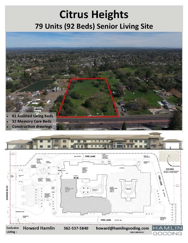


This Property Is For Sale
NEARBY LISTINGS FOR SALE OR LEASE
Property Detail
8220 Sunrise Blvd
Sacramento--Roseville--Arden-Arcade, CA
Citrus Heights Add
216-0090-012
PORTION LOT180
Residentialacreage
Sacramento
X
California
06067C0084J
180
2024
4.55 AC
2025
Citrus Heights/Orangevale
008124
Sacramento
2,228 SF
DEMOGRAPHICS near 8220 Sunrise Blvd
1 Mile
3 Mile
5 Mile
2024 Total Population
15,502
124,708
322,501
2029 Population
15,786
128,245
331,225
Pop Growth 2024-2029
+ 1.83%
+ 2.84%
+ 2.71%
Average Age
42
41
41
2024 Total Households
5,835
48,198
122,405
HH Growth 2024-2029
+ 1.83%
+ 2.92%
+ 2.72%
Median Household Inc
$83,530
$79,982
$88,165
Avg Household Size
2.60
2.50
2.60
2024 Avg HH Vehicles
2.00
2.00
2.00
Median Home Value
$489,753
$454,667
$478,907
Median Year Built
1979
1978
1981
Nearby Places
Map Layers
Map Styles
 Street
 Aerial
- Restaurants
- Banks
- Shops
- Fitness
- Groceries
PUBLIC TRANSPORTATION
COMMUTER RAIL
Roseville (California Zephyr - Amtrak, Capitol Corridor - Amtrak)
DRIVE
WALK
Distance
Roseville (California Zephyr - Amtrak, Capitol Corridor - Amtrak)
10 min
4.1 mi
Rocklin Amtrak Station (Capitol Corridor - Amtrak)
DRIVE
WALK
Distance
Rocklin Amtrak Station (Capitol Corridor - Amtrak)
11 min
6.0 mi
AIRPORT
Sacramento International
DRIVE
WALK
Distance
Sacramento International
33 min
24.1 mi
Freight Ports
Port of Stockton
DRIVE
WALK
Distance
Port of Stockton
75 min
64.3 mi
Nearby Properties
Address
Land Use
TOTAL SIZE
Lot Size
Zoning
Address
Land Use
TOTAL SIZE
Lot Size
Zoning
1,444,630 SF
53.20 AC
Address
Land Use
TOTAL SIZE
Lot Size
Zoning
638,040 SF
38.70 AC
Address
Land Use
TOTAL SIZE
Lot Size
Zoning
277,602 SF
26.49 AC
Address
Land Use
TOTAL SIZE
Lot Size
Zoning
210,380 SF
14.26 AC
Address
Land Use
TOTAL SIZE
Lot Size
Zoning
251,225 SF
23.54 AC
SC
Address
Land Use
TOTAL SIZE
Lot Size
Zoning
263,682 SF
14.40 AC
Address
Land Use
TOTAL SIZE
Lot Size
Zoning
120,983 SF
17.60 AC
Address
Land Use
TOTAL SIZE
Lot Size
Zoning
142,063 SF
8.70 AC
Address
Land Use
TOTAL SIZE
Lot Size
Zoning
78,730 SF
8.03 AC
RD20 BP
Address
Land Use
TOTAL SIZE
Lot Size
Zoning
118,155 SF
3.80 AC
Address
Land Use
TOTAL SIZE
Lot Size
Zoning
128,480 SF
7.95 AC
RD30 BP
Address
Land Use
TOTAL SIZE
Lot Size
Zoning
119,417 SF
11 AC
Address
Land Use
TOTAL SIZE
Lot Size
Zoning
126,521 SF
11 AC
Address
Land Use
TOTAL SIZE
Lot Size
Zoning
156,365 SF
12.81 AC
SC
Address
Land Use
TOTAL SIZE
Lot Size
Zoning
166,268 SF
9.50 AC
RD30
Address
Land Use
TOTAL SIZE
Lot Size
Zoning
148,663 SF
13.19 AC
SPA
Address
Land Use
TOTAL SIZE
Lot Size
Zoning
98,508 SF
5.33 AC
RD20
Address
Land Use
TOTAL SIZE
Lot Size
Zoning
109,098 SF
5.50 AC
Address
Land Use
TOTAL SIZE
Lot Size
Zoning
153,746 SF
15.20 AC
Address
Land Use
TOTAL SIZE
Lot Size
Zoning
111,418 SF
10.90 AC
Address
Land Use
TOTAL SIZE
Lot Size
Zoning
111,185 SF
8.10 AC
Address
Land Use
TOTAL SIZE
Lot Size
Zoning
137,732 SF
12.87 AC
SC
Address
Land Use
TOTAL SIZE
Lot Size
Zoning
97,703 SF
9.60 AC
Address
Land Use
TOTAL SIZE
Lot Size
Zoning
162,401 SF
5.29 AC
Address
Land Use
TOTAL SIZE
Lot Size
Zoning
254,982 SF
19.60 AC
Address
Land Use
TOTAL SIZE
Lot Size
Zoning
268,502 SF
12.38 AC
RD30
Address
Land Use
TOTAL SIZE
Lot Size
Zoning
96,799 SF
7.40 AC
Address
Land Use
TOTAL SIZE
Lot Size
Zoning
220,691 SF
18.28 AC
RD20
Address
Land Use
TOTAL SIZE
Lot Size
Zoning
141,279 SF
11.56 AC
SPA
Address
Land Use
TOTAL SIZE
Lot Size
Zoning
61,056 SF
4.50 AC
The World's #1 Commercial Real Estate Marketplace
Connect with us
© 2026 CoStar Group
The information above has been obtained from sources believed reliable. While we do not doubt its accuracy we have not verified it and make no guarantee, warranty or representation about it. It is your responsibility to independently confirm its accuracy and completeness. Any projections, opinions, assumptions, or estimates used are for example only and do not represent the current or future performance of the property. The value of this transaction to you depends on tax and other factors which should be evaluated by your tax, financial, and legal advisors. You and your advisors should conduct a careful, independent investigation of the property to determine to your satisfaction the suitability of the property for your needs.