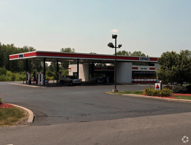
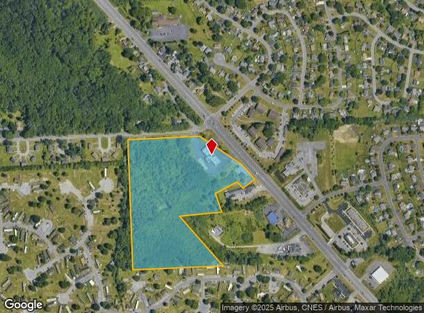
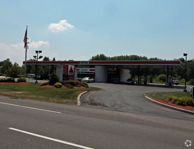
Property Record
8223 Oswego Rd, Baldwinsville, NY 13027
NEARBY LISTINGS FOR SALE OR LEASE
Property Detail
8223 Oswego Rd
312489-066-000-0001-041-001-0000
Onondaga
Servicestationmarket
New York
AE
41.001
36067C0086F
17.26 AC
2025
NE Outer Onondaga County
2024
Syracuse
011600
Syracuse, NY
1,344 SF
DEMOGRAPHICS near 8223 Oswego Rd
1 Mile
3 Mile
5 Mile
2024 Total Population
8,384
35,221
79,549
2029 Population
8,184
34,303
77,535
Pop Growth 2024-2029
(2.39%)
(2.61%)
(2.53%)
Average Age
41
42
42
2024 Total Households
3,318
14,309
33,655
HH Growth 2024-2029
(2.71%)
(2.81%)
(2.72%)
Median Household Inc
$76,303
$85,073
$76,376
Avg Household Size
2.50
2.40
2.30
2024 Avg HH Vehicles
2.00
2.00
2.00
Median Home Value
$179,487
$185,502
$178,899
Median Year Built
1985
1981
1977
Nearby Places
- Restaurants
- Banks
- Shops
- Fitness
- Groceries
PUBLIC TRANSPORTATION
COMMUTER RAIL
Syracuse (Toronto - New York - VIA Rail)
DRIVE
WALK
Distance
Syracuse (Toronto - New York - VIA Rail)
17 min
8.2 mi
AIRPORT
Syracuse Hancock International
DRIVE
WALK
Distance
Syracuse Hancock International
19 min
13.5 mi
Freight Ports
Albany, NY Port
DRIVE
WALK
Distance
Albany, NY Port
181 min
151.0 mi
Nearby Properties
Address
Land Use
TOTAL SIZE
Lot Size
Zoning
Address
Land Use
TOTAL SIZE
Lot Size
Zoning
7,392 SF
14.86 AC
03 - MULTI
Address
Land Use
TOTAL SIZE
Lot Size
Zoning
38,960 SF
21.26 AC
PUD
Address
Land Use
TOTAL SIZE
Lot Size
Zoning
57,993 SF
18.43 AC
02 - SINGL
Address
Land Use
TOTAL SIZE
Lot Size
Zoning
3,744 SF
10.60 AC
03 - MULTI
Address
Land Use
TOTAL SIZE
Lot Size
Zoning
3,696 SF
10.12 AC
03 - MULTI
Address
Land Use
TOTAL SIZE
Lot Size
Zoning
99,442 SF
11.75 AC
PUD
Address
Land Use
TOTAL SIZE
Lot Size
Zoning
28,800 SF
6.86 AC
R40
Address
Land Use
TOTAL SIZE
Lot Size
Zoning
5,400 SF
6.47 AC
PUD
Address
Land Use
TOTAL SIZE
Lot Size
Zoning
61,701 SF
15.87 AC
R40
Address
Land Use
TOTAL SIZE
Lot Size
Zoning
28,800 SF
4.72 AC
PUD
Address
Land Use
TOTAL SIZE
Lot Size
Zoning
34,535 SF
5 AC
PUD
Address
Land Use
TOTAL SIZE
Lot Size
Zoning
28,800 SF
3.19 AC
PUD
Address
Land Use
TOTAL SIZE
Lot Size
Zoning
10,330 SF
241.94 AC
PUD
Address
Land Use
TOTAL SIZE
Lot Size
Zoning
309,390 SF
68.49 AC
05 - COMME
Address
Land Use
TOTAL SIZE
Lot Size
Zoning
33,962 SF
12.04 AC
03 - MULTI
Address
Land Use
TOTAL SIZE
Lot Size
Zoning
17,725 SF
4.91 AC
PUD
Address
Land Use
TOTAL SIZE
Lot Size
Zoning
6,528 SF
27.74 AC
PUD
Address
Land Use
TOTAL SIZE
Lot Size
Zoning
2,920 SF
13.70 AC
PUD
Address
Land Use
TOTAL SIZE
Lot Size
Zoning
6,724 SF
10.05 AC
PUD
Address
Land Use
TOTAL SIZE
Lot Size
Zoning
17,628 SF
2.76 AC
PUD
Address
Land Use
TOTAL SIZE
Lot Size
Zoning
24,830 SF
3.77 AC
PUD
Address
Land Use
TOTAL SIZE
Lot Size
Zoning
43,420 SF
5.02 AC
PUD
Address
Land Use
TOTAL SIZE
Lot Size
Zoning
29,682 SF
3.03 AC
PUD
Address
Land Use
TOTAL SIZE
Lot Size
Zoning
29,700 SF
2.50 AC
PUD
Address
Land Use
TOTAL SIZE
Lot Size
Zoning
43,592 SF
8.14 AC
PUD
Address
Land Use
TOTAL SIZE
Lot Size
Zoning
6,672 SF
4.04 AC
03 - MULTI
Address
Land Use
TOTAL SIZE
Lot Size
Zoning
12,312 SF
40.32 AC
05 - COMME
Address
Land Use
TOTAL SIZE
Lot Size
Zoning
62,496 SF
26.34 AC
04 - FARM
Address
Land Use
TOTAL SIZE
Lot Size
Zoning
11,504 SF
2 AC
R40
Address
Land Use
TOTAL SIZE
Lot Size
Zoning
5,736 SF
1.08 AC
PUD
The World's #1 Commercial Real Estate Marketplace
Connect with us
© 2025 CoStar Group
The information above has been obtained from sources believed reliable. While we do not doubt its accuracy we have not verified it and make no guarantee, warranty or representation about it. It is your responsibility to independently confirm its accuracy and completeness. Any projections, opinions, assumptions, or estimates used are for example only and do not represent the current or future performance of the property. The value of this transaction to you depends on tax and other factors which should be evaluated by your tax, financial, and legal advisors. You and your advisors should conduct a careful, independent investigation of the property to determine to your satisfaction the suitability of the property for your needs.