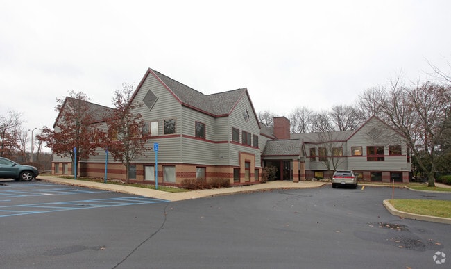
Property Record
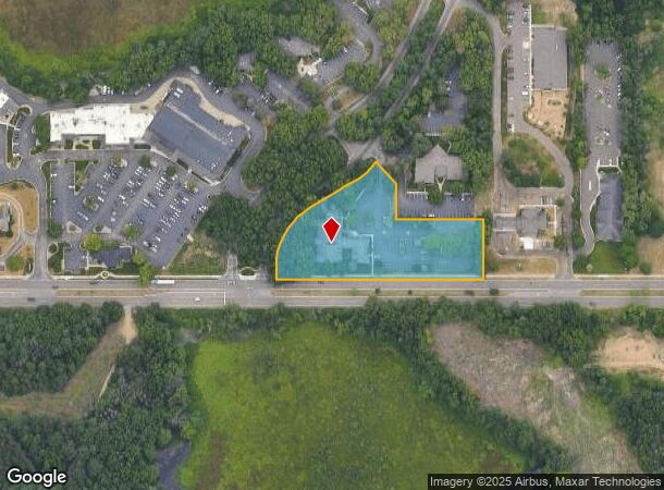
8225 Moorsbridge Rd, Portage, MI 49024
NEARBY LISTINGS FOR SALE OR LEASE
Property Detail
8225 Moorsbridge Rd
10-00019-005-O
COMM AT THE NE CORNER OF SEC 19-3-11; TH S0DEG08'30"E 1332.17 FT ALONG THE E LI OF THE NE 1/4 OF SAID SEC TO THE S LI OF THE
Commercialnec
Kalamazoo
X
Michigan
26077C0284E
2.99 AC
2025
Southern Kalamazoo County
2025
West Michigan
002004
Kalamazoo-Portage, MI
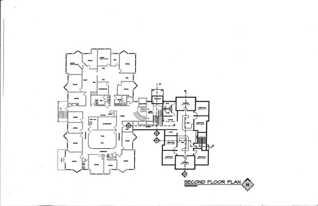
15,883 SF
DEMOGRAPHICS near 8225 Moorsbridge Rd
1 Mile
3 Mile
5 Mile
2024 Total Population
3,734
37,718
75,114
2029 Population
3,720
37,515
74,690
Pop Growth 2024-2029
(0.37%)
(0.54%)
(0.56%)
Average Age
42
40
40
2024 Total Households
1,808
15,032
31,217
HH Growth 2024-2029
(0.06%)
(0.57%)
(0.63%)
Median Household Inc
$77,037
$84,507
$73,753
Avg Household Size
2.00
2.40
2.30
2024 Avg HH Vehicles
2.00
2.00
2.00
Median Home Value
$295,578
$248,947
$243,812
Median Year Built
1986
1981
1977
Nearby Places
Map Layers
Map Styles
 Street
 Aerial
- Restaurants
- Banks
- Shops
- Fitness
- Groceries
PUBLIC TRANSPORTATION
AIRPORT
Kalamazoo/Battle Creek International
DRIVE
WALK
Distance
Kalamazoo/Battle Creek International
18 min
9.1 mi
Freight Ports
Port of Toledo
DRIVE
WALK
Distance
Port of Toledo
181 min
150.5 mi
SALE & LEASE HISTORY
LISTING DATE
SALE/LEASE

Feb 11, 2022
For Lease
Dec 28, 2021
For Lease
Aug 03, 2023
For Sale
Aug 02, 2023
For Sale
Nearby Properties
Address
Land Use
TOTAL SIZE
Lot Size
Zoning
Address
Land Use
TOTAL SIZE
Lot Size
Zoning
383,638 SF
25.85 AC
B-2
Address
Land Use
TOTAL SIZE
Lot Size
Zoning
17.31 AC
PD
Address
Land Use
TOTAL SIZE
Lot Size
Zoning
16.71 AC
B-2
Address
Land Use
TOTAL SIZE
Lot Size
Zoning
9.47 AC
Address
Land Use
TOTAL SIZE
Lot Size
Zoning
16.75 AC
CBD
Address
Land Use
TOTAL SIZE
Lot Size
Zoning
5,173 SF
15.81 AC
RM-1
Address
Land Use
TOTAL SIZE
Lot Size
Zoning
61,533 SF
8.42 AC
B-2
Address
Land Use
TOTAL SIZE
Lot Size
Zoning
18.57 AC
Address
Land Use
TOTAL SIZE
Lot Size
Zoning
1,776 SF
17 AC
PD
Address
Land Use
TOTAL SIZE
Lot Size
Zoning
23,463 SF
15 AC
PD
Address
Land Use
TOTAL SIZE
Lot Size
Zoning
16.58 AC
Address
Land Use
TOTAL SIZE
Lot Size
Zoning
12,480 SF
14.82 AC
RM-1
Address
Land Use
TOTAL SIZE
Lot Size
Zoning
6,874 SF
163.50 AC
PD
Address
Land Use
TOTAL SIZE
Lot Size
Zoning
151,395 SF
33.79 AC
CPD
Address
Land Use
TOTAL SIZE
Lot Size
Zoning
66.34 AC
B-3
Address
Land Use
TOTAL SIZE
Lot Size
Zoning
26,700 SF
17 AC
RM-1
Address
Land Use
TOTAL SIZE
Lot Size
Zoning
188,352 SF
67.55 AC
Address
Land Use
TOTAL SIZE
Lot Size
Zoning
8,040 SF
18.11 AC
RM-1
Address
Land Use
TOTAL SIZE
Lot Size
Zoning
32,094 SF
13.95 AC
PD
Address
Land Use
TOTAL SIZE
Lot Size
Zoning
21,180 SF
13.12 AC
RM-1
Address
Land Use
TOTAL SIZE
Lot Size
Zoning
20,760 SF
12.86 AC
RM-1
Address
Land Use
TOTAL SIZE
Lot Size
Zoning
9,246 SF
10.24 AC
RM-1
Address
Land Use
TOTAL SIZE
Lot Size
Zoning
168,173 SF
16.32 AC
I-2
Address
Land Use
TOTAL SIZE
Lot Size
Zoning
103,007 SF
8.02 AC
B-2
Address
Land Use
TOTAL SIZE
Lot Size
Zoning
7.18 AC
CBD
Address
Land Use
TOTAL SIZE
Lot Size
Zoning
5,880 SF
9.65 AC
RM-1
Address
Land Use
TOTAL SIZE
Lot Size
Zoning
8.92 AC
PD
Address
Land Use
TOTAL SIZE
Lot Size
Zoning
29,341 SF
5.72 AC
B-2
Address
Land Use
TOTAL SIZE
Lot Size
Zoning
26.89 AC
PD
Address
Land Use
TOTAL SIZE
Lot Size
Zoning
35,419 SF
6.70 AC
B-3
The World's #1 Commercial Real Estate Marketplace
Connect with us
© 2026 CoStar Group
The information above has been obtained from sources believed reliable. While we do not doubt its accuracy we have not verified it and make no guarantee, warranty or representation about it. It is your responsibility to independently confirm its accuracy and completeness. Any projections, opinions, assumptions, or estimates used are for example only and do not represent the current or future performance of the property. The value of this transaction to you depends on tax and other factors which should be evaluated by your tax, financial, and legal advisors. You and your advisors should conduct a careful, independent investigation of the property to determine to your satisfaction the suitability of the property for your needs.