Property Record
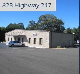
823 Highway 247 S, Kathleen, GA 31047


NEARBY LISTINGS FOR SALE OR LEASE
Property Detail
823 Highway 247 S
Warner Robins, GA
Hwy 247 Conn 45
00126A46A000
LOT 9-B 0.93 AC LL 42 11TH LD
Officebuilding
Houston
X
Georgia
13289C0200B
9-b
2024
0.93 AC
2024
Perry/Warner Robins
021108
Other Market Areas
3,600 SF
DEMOGRAPHICS near 823 Highway 247 S
1 Mile
3 Mile
5 Mile
2024 Total Population
3,161
17,573
48,641
2029 Population
3,529
19,515
53,552
Pop Growth 2024-2029
+ 11.64%
+ 11.05%
+ 10.10%
Average Age
34
36
37
2024 Total Households
969
5,884
17,671
HH Growth 2024-2029
+ 11.46%
+ 10.79%
+ 9.87%
Median Household Inc
$105,578
$108,624
$92,419
Avg Household Size
3.20
3.00
2.70
2024 Avg HH Vehicles
2.00
3.00
2.00
Median Home Value
$256,781
$247,538
$205,855
Median Year Built
2009
2006
2000
Nearby Places
Map Layers
Map Styles
 Street
 Aerial
- Restaurants
- Banks
- Shops
- Fitness
- Groceries
SALE & LEASE HISTORY
LISTING DATE
SALE/LEASE

Sep 25, 2016
For Lease
Nearby Properties
Address
Land Use
TOTAL SIZE
Lot Size
Zoning
Address
Land Use
TOTAL SIZE
Lot Size
Zoning
180,000 SF
146.60 AC
RAG
Address
Land Use
TOTAL SIZE
Lot Size
Zoning
139,756 SF
34.14 AC
R1
Address
Land Use
TOTAL SIZE
Lot Size
Zoning
134,400 SF
22.43 AC
R1
Address
Land Use
TOTAL SIZE
Lot Size
Zoning
106,055 SF
35.17 AC
R1
Address
Land Use
TOTAL SIZE
Lot Size
Zoning
100,000 SF
12.12 AC
RAG
Address
Land Use
TOTAL SIZE
Lot Size
Zoning
48,462 SF
5.54 AC
C2
Address
Land Use
TOTAL SIZE
Lot Size
Zoning
19,200 SF
8.51 AC
R1
Address
Land Use
TOTAL SIZE
Lot Size
Zoning
4,830 SF
3.83 AC
M1
Address
Land Use
TOTAL SIZE
Lot Size
Zoning
45,749 SF
4.95 AC
C2
Address
Land Use
TOTAL SIZE
Lot Size
Zoning
18,633 SF
6.54 AC
PUD
Address
Land Use
TOTAL SIZE
Lot Size
Zoning
2,400 SF
4.15 AC
PUD
Address
Land Use
TOTAL SIZE
Lot Size
Zoning
107.14 AC
R1 C2
Address
Land Use
TOTAL SIZE
Lot Size
Zoning
13,278 SF
1.81 AC
C1
Address
Land Use
TOTAL SIZE
Lot Size
Zoning
969.59 AC
RAG
Address
Land Use
TOTAL SIZE
Lot Size
Zoning
64.64 AC
R3
Address
Land Use
TOTAL SIZE
Lot Size
Zoning
1,036 SF
324.10 AC
RAG
Address
Land Use
TOTAL SIZE
Lot Size
Zoning
7,320 SF
144.55 AC
R1
Address
Land Use
TOTAL SIZE
Lot Size
Zoning
3,307 SF
6.40 AC
R1
Address
Land Use
TOTAL SIZE
Lot Size
Zoning
28,907 SF
3.66 AC
C2
Address
Land Use
TOTAL SIZE
Lot Size
Zoning
5,400 SF
1.88 AC
M1
Address
Land Use
TOTAL SIZE
Lot Size
Zoning
115.78 AC
RAG
Address
Land Use
TOTAL SIZE
Lot Size
Zoning
13,450 SF
0.69 AC
RAG
Address
Land Use
TOTAL SIZE
Lot Size
Zoning
27,639 SF
2.18 AC
C2
Address
Land Use
TOTAL SIZE
Lot Size
Zoning
2,650 SF
5.49 AC
RAG
Address
Land Use
TOTAL SIZE
Lot Size
Zoning
2,940 SF
135.44 AC
RAG
Address
Land Use
TOTAL SIZE
Lot Size
Zoning
180.57 AC
RAG
Address
Land Use
TOTAL SIZE
Lot Size
Zoning
134.58 AC
RAG
Address
Land Use
TOTAL SIZE
Lot Size
Zoning
101.34 AC
R3
Address
Land Use
TOTAL SIZE
Lot Size
Zoning
70.69 AC
R3
Address
Land Use
TOTAL SIZE
Lot Size
Zoning
9,504 SF
1.83 AC
C2
The World's #1 Commercial Real Estate Marketplace
Connect with us
© 2026 CoStar Group
The information above has been obtained from sources believed reliable. While we do not doubt its accuracy we have not verified it and make no guarantee, warranty or representation about it. It is your responsibility to independently confirm its accuracy and completeness. Any projections, opinions, assumptions, or estimates used are for example only and do not represent the current or future performance of the property. The value of this transaction to you depends on tax and other factors which should be evaluated by your tax, financial, and legal advisors. You and your advisors should conduct a careful, independent investigation of the property to determine to your satisfaction the suitability of the property for your needs.