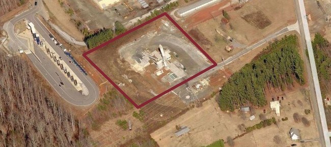
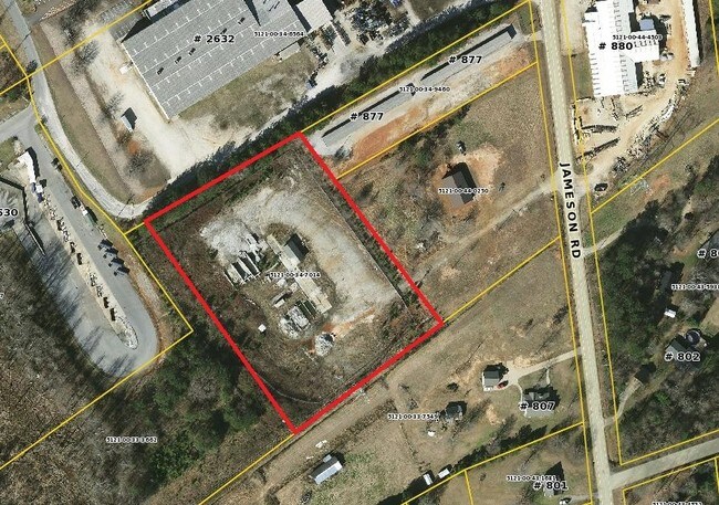
Property Record
823 Jameson Rd, Easley, SC 29640

Property Detail
823 Jameson Rd
5121-00-34-7014
PLAT 497/10A TRACT C, W SIDE JAMESON RD
Vacantlandnec
PICKENS
B and X Area of moderate flood hazard, usually the area between the limits of the 100-year and 500-year floods.
South Carolina
2025
4.18 AC
2025
Outlying Pickens County
010802
Greenville/Spartanburg
1,056 SF
Greenville-Anderson-Greer, SC
NEARBY LISTINGS FOR SALE OR LEASE
-
-
View all Easley listings for sale on LoopNet.com
DEMOGRAPHICS near 823 Jameson Rd
1 mile
3 mile
5 mile
2025 Total Population
885
8,720
33,764
2030 Population
928
9,260
35,612
Pop Growth 2025-2030
+ 4.86%
+ 6.19%
+ 5.47%
Average Age
43
43
42
2025 Total Households
330
3,429
13,994
HH Growth 2025-2030
+ 5.15%
+ 6.56%
+ 5.75%
Median Household Inc
$72,169
$60,613
$57,335
Avg Household Size
2.70
2.50
2.40
2025 Avg HH Vehicles
3.00
2.00
2.00
Median Home Value
$312,000
$258,201
$236,880
Median Year Built
1992
1992
1987
Nearby Places
Map Layers
Map Styles
 Street
 Aerial
Transit
 Traffic
 Biking
Places
Listings with unknown addresses are not visible on the map
- Restaurants
- Banks
- Shops
- Fitness
- Groceries
PUBLIC TRANSPORTATION
AIRPORT
Greenville Spartanburg International
Drive
Walk
Distance
Greenville Spartanburg International
44 min
26.5 mi
Freight Ports
North Charleston Terminal
Drive
Walk
Distance
North Charleston Terminal
251 min
217.1 mi
SALE & LEASE HISTORY
LISTING DATE
SALE/LEASE

Sep 24, 2016
For Sale
Jul 03, 2017
For Sale
Nearby Properties
Address
Land Use
TOTAL SIZE
Lot Size
Zoning
Address
Land Use
TOTAL SIZE
Lot Size
Zoning
52,710 SF
9.75 AC
Address
Land Use
TOTAL SIZE
Lot Size
Zoning
29,695 SF
4 AC
Address
Land Use
TOTAL SIZE
Lot Size
Zoning
16,800 SF
8.85 AC
GENERAL RE
Address
Land Use
TOTAL SIZE
Lot Size
Zoning
47,571 SF
4.49 AC
GENERAL RE
Address
Land Use
TOTAL SIZE
Lot Size
Zoning
11,359 SF
7.74 AC
Address
Land Use
TOTAL SIZE
Lot Size
Zoning
18,240 SF
4 AC
Address
Land Use
TOTAL SIZE
Lot Size
Zoning
24,732 SF
3.70 AC
MED MEDICA
Address
Land Use
TOTAL SIZE
Lot Size
Zoning
37.93 AC
Address
Land Use
TOTAL SIZE
Lot Size
Zoning
1,400 SF
3.94 AC
Address
Land Use
TOTAL SIZE
Lot Size
Zoning
17.21 AC
R 10 ONE F
Address
Land Use
TOTAL SIZE
Lot Size
Zoning
40.30 AC
R 10 ONE F
Address
Land Use
TOTAL SIZE
Lot Size
Zoning
19.53 AC
Address
Land Use
TOTAL SIZE
Lot Size
Zoning
258,771 SF
58 AC
Address
Land Use
TOTAL SIZE
Lot Size
Zoning
750 SF
2.86 AC
Address
Land Use
TOTAL SIZE
Lot Size
Zoning
32,117 SF
8.03 AC
Address
Land Use
TOTAL SIZE
Lot Size
Zoning
Address
Land Use
TOTAL SIZE
Lot Size
Zoning
8.36 AC
Address
Land Use
TOTAL SIZE
Lot Size
Zoning
9.54 AC
Address
Land Use
TOTAL SIZE
Lot Size
Zoning
10.15 AC
Address
Land Use
TOTAL SIZE
Lot Size
Zoning
2,760 SF
102 AC
Address
Land Use
TOTAL SIZE
Lot Size
Zoning
9,177 SF
2.80 AC
Address
Land Use
TOTAL SIZE
Lot Size
Zoning
8.79 AC
Address
Land Use
TOTAL SIZE
Lot Size
Zoning
14,166 SF
0.95 AC
MED MEDICA
Address
Land Use
TOTAL SIZE
Lot Size
Zoning
14,166 SF
0.92 AC
MED MEDICA
Address
Land Use
TOTAL SIZE
Lot Size
Zoning
6.30 AC
Address
Land Use
TOTAL SIZE
Lot Size
Zoning
9,016 SF
0.89 AC
Address
Land Use
TOTAL SIZE
Lot Size
Zoning
3,250 SF
15.08 AC
Address
Land Use
TOTAL SIZE
Lot Size
Zoning
50.48 AC
Address
Land Use
TOTAL SIZE
Lot Size
Zoning
2,146 SF
0.78 AC
Address
Land Use
TOTAL SIZE
Lot Size
Zoning
15,000 SF
1.68 AC
The World's #1 Commercial Real Estate Marketplace
Connect with us
© 2026 CoStar Group
The information above has been obtained from sources believed reliable. While we do not doubt its accuracy we have not verified it and make no guarantee, warranty or representation about it. It is your responsibility to independently confirm its accuracy and completeness. Any projections, opinions, assumptions, or estimates used are for example only and do not represent the current or future performance of the property. The value of this transaction to you depends on tax and other factors which should be evaluated by your tax, financial, and legal advisors. You and your advisors should conduct a careful, independent investigation of the property to determine to your satisfaction the suitability of the property for your needs.