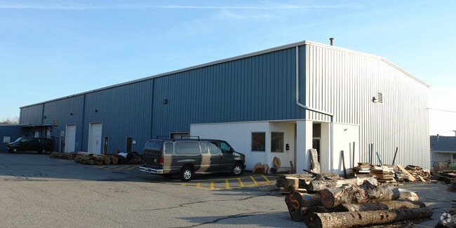
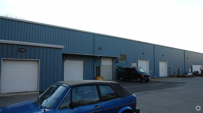
Property Record
823 W Main Rd, Middletown, RI 02842

Save to a Folder
{{folder.Name}}
{{folder.ListingIds.length}} Properties
{{folder.ListingIds.length}} Property
Create a New Folder
Property Detail
823 W Main Rd
MIDD-000107-N000000E-000015A
Newport
Commercialbuilding
Rhode Island
GBA
15a
B and X Area of moderate flood hazard, usually the area between the limits of the 100-year and 500-year floods.
1.30 AC
2025
Newport County
2025
Providence
040304
Providence-Warwick, RI-MA
14,250 SF
NEARBY LISTINGS FOR SALE OR LEASE
DEMOGRAPHICS near 823 W Main Rd
1 mile
3 mile
5 mile
2025 Total Population
8,716
37,221
56,134
2030 Population
9,123
36,772
55,184
Pop Growth 2025-2030
+ 4.67%
(1.21%)
(1.69%)
Average Age
39
43
44
2025 Total Households
3,798
16,041
23,721
HH Growth 2025-2030
(3.77%)
(2.61%)
(2.36%)
Median Household Inc
$91,346
$90,643
$103,297
Avg Household Size
2.20
2.20
2.20
2025 Avg HH Vehicles
2.00
2.00
2.00
Median Home Value
$452,819
$667,936
$742,570
Median Year Built
1991
1965
1964
Nearby Places
Map Layers
Map Styles
 Street
 Aerial
Layers
 Traffic
 Biking
Places
Listings with unknown addresses are not visible on the map
- Restaurants
- Banks
- Shops
- Fitness
- Groceries
PUBLIC TRANSPORTATION
AIRPORT
Rhode Island Tf Green International
Drive
Walk
Distance
Rhode Island Tf Green International
49 min
30.0 mi
Nearby Properties
Address
Land Use
TOTAL SIZE
Lot Size
Zoning
Address
Land Use
TOTAL SIZE
Lot Size
Zoning
60.03 AC
R40
Address
Land Use
TOTAL SIZE
Lot Size
Zoning
264,032 SF
3.73 AC
GB
Address
Land Use
TOTAL SIZE
Lot Size
Zoning
237,976 SF
8.99 AC
WB
Address
Land Use
TOTAL SIZE
Lot Size
Zoning
143,311 SF
2.94 AC
GB
Address
Land Use
TOTAL SIZE
Lot Size
Zoning
104.20 AC
P
Address
Land Use
TOTAL SIZE
Lot Size
Zoning
249,902 SF
27.88 AC
UV
Address
Land Use
TOTAL SIZE
Lot Size
Zoning
24.70 AC
RMA
Address
Land Use
TOTAL SIZE
Lot Size
Zoning
76,534 SF
5.29 AC
WB
Address
Land Use
TOTAL SIZE
Lot Size
Zoning
86,091 SF
6.50 AC
CI
Address
Land Use
TOTAL SIZE
Lot Size
Zoning
157,806 SF
36.80 AC
R30
Address
Land Use
TOTAL SIZE
Lot Size
Zoning
158,333 SF
1.81 AC
R10
Address
Land Use
TOTAL SIZE
Lot Size
Zoning
82.64 AC
Address
Land Use
TOTAL SIZE
Lot Size
Zoning
217,212 SF
10.46 AC
R10
Address
Land Use
TOTAL SIZE
Lot Size
Zoning
33 AC
PA
Address
Land Use
TOTAL SIZE
Lot Size
Zoning
172,320 SF
10.14 AC
R10
Address
Land Use
TOTAL SIZE
Lot Size
Zoning
17.92 AC
RMA
Address
Land Use
TOTAL SIZE
Lot Size
Zoning
108,365 SF
5.15 AC
R10
Address
Land Use
TOTAL SIZE
Lot Size
Zoning
36,984 SF
10 AC
R10
Address
Land Use
TOTAL SIZE
Lot Size
Zoning
Address
Land Use
TOTAL SIZE
Lot Size
Zoning
151,202 SF
15.98 AC
PA
Address
Land Use
TOTAL SIZE
Lot Size
Zoning
50,220 SF
8.83 AC
TM
Address
Land Use
TOTAL SIZE
Lot Size
Zoning
45,283 SF
1.66 AC
WB
Address
Land Use
TOTAL SIZE
Lot Size
Zoning
12.18 AC
GBA
Address
Land Use
TOTAL SIZE
Lot Size
Zoning
130,460 SF
10.15 AC
OP
Address
Land Use
TOTAL SIZE
Lot Size
Zoning
64,232 SF
7.69 AC
R20
Address
Land Use
TOTAL SIZE
Lot Size
Zoning
121,259 SF
6.40 AC
GB
Address
Land Use
TOTAL SIZE
Lot Size
Zoning
64,472 SF
4.88 AC
GB
Address
Land Use
TOTAL SIZE
Lot Size
Zoning
56,313 SF
0.53 AC
GB
Address
Land Use
TOTAL SIZE
Lot Size
Zoning
26.66 AC
R20
Address
Land Use
TOTAL SIZE
Lot Size
Zoning
2,713 SF
36.08 AC
OS
The World's #1 Commercial Real Estate Marketplace
Connect with us
© 2026 CoStar Group
The information above has been obtained from sources believed reliable. While we do not doubt its accuracy we have not verified it and make no guarantee, warranty or representation about it. It is your responsibility to independently confirm its accuracy and completeness. Any projections, opinions, assumptions, or estimates used are for example only and do not represent the current or future performance of the property. The value of this transaction to you depends on tax and other factors which should be evaluated by your tax, financial, and legal advisors. You and your advisors should conduct a careful, independent investigation of the property to determine to your satisfaction the suitability of the property for your needs.