Property Record
8234 Cessna Dr, Peyton, CO 80831
NEARBY LISTINGS FOR SALE OR LEASE
-
-
View all Peyton listings for sale on LoopNet.com
Property Detail
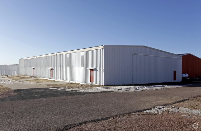
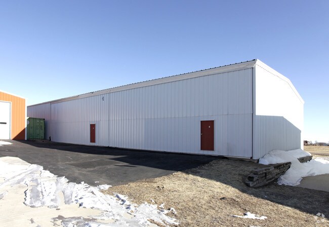
8234 Cessna Dr
Colorado Springs, CO
Falcon Hangars Condominiums
43040-02-124
CONDOMINIUM UNIT 1, BLDG E, FALCON HANGARS CONDOMINIUMS, ACCORDING TO THE DECLARATION THEREOF FILED FOR RECORD IN THE OFFICE OF THE CLERK & RECORDER OF EL PASO COUNTY, STATE OF COLORADO, ON MARCH 24, 2000 AT REC #200031073, AND AS DEFINED AND DESCRIB
Commercialcondominium
El Paso
X
Colorado
08041C0554G
1
2024
0.03 AC
2025
Southeast
005123
Colorado Springs
1,333 SF
DEMOGRAPHICS near 8234 Cessna Dr
1 Mile
3 Mile
5 Mile
2024 Total Population
286
21,003
32,316
2029 Population
299
21,951
33,905
Pop Growth 2024-2029
+ 4.55%
+ 4.51%
+ 4.92%
Average Age
41
35
36
2024 Total Households
107
6,489
10,266
HH Growth 2024-2029
+ 4.67%
+ 4.73%
+ 5.10%
Median Household Inc
$59,999
$120,004
$122,040
Avg Household Size
2.70
3.20
3.10
2024 Avg HH Vehicles
2.00
3.00
3.00
Median Home Value
$540,540
$437,744
$449,545
Median Year Built
2003
2006
2007
Nearby Places
Map Layers
Map Styles
 Street
 Aerial
- Restaurants
- Banks
- Shops
- Fitness
- Groceries
PUBLIC TRANSPORTATION
AIRPORT
City of Colorado Springs Municipal
DRIVE
WALK
Distance
City of Colorado Springs Municipal
26 min
13.6 mi
Nearby Properties
Address
Land Use
TOTAL SIZE
Lot Size
Zoning
Address
Land Use
TOTAL SIZE
Lot Size
Zoning
43,256 SF
4.49 AC
PUD
Address
Land Use
TOTAL SIZE
Lot Size
Zoning
43,256 SF
4.73 AC
Address
Land Use
TOTAL SIZE
Lot Size
Zoning
39,446 SF
10.71 AC
RR-5
Address
Land Use
TOTAL SIZE
Lot Size
Zoning
123,673 SF
9.98 AC
CR
Address
Land Use
TOTAL SIZE
Lot Size
Zoning
195,448 SF
19.86 AC
CR
Address
Land Use
TOTAL SIZE
Lot Size
Zoning
46,935 SF
13.62 AC
PUD
Address
Land Use
TOTAL SIZE
Lot Size
Zoning
16,915 SF
5.19 AC
PUD
Address
Land Use
TOTAL SIZE
Lot Size
Zoning
7,573 SF
757.70 AC
PUD R-4 R-
Address
Land Use
TOTAL SIZE
Lot Size
Zoning
16,455 SF
6.89 AC
A-35 RR-2.
Address
Land Use
TOTAL SIZE
Lot Size
Zoning
15,406 SF
5.42 AC
RR-5
Address
Land Use
TOTAL SIZE
Lot Size
Zoning
10,017 SF
1.50 AC
CR
Address
Land Use
TOTAL SIZE
Lot Size
Zoning
13,048 SF
1.63 AC
CR
Address
Land Use
TOTAL SIZE
Lot Size
Zoning
3,148 SF
0.58 AC
CR
Address
Land Use
TOTAL SIZE
Lot Size
Zoning
38,804 SF
39.37 AC
RR-5
Address
Land Use
TOTAL SIZE
Lot Size
Zoning
41,592 SF
8.59 AC
RR-5
Address
Land Use
TOTAL SIZE
Lot Size
Zoning
700 SF
53.98 AC
Address
Land Use
TOTAL SIZE
Lot Size
Zoning
6,289 SF
2.04 AC
CC
Address
Land Use
TOTAL SIZE
Lot Size
Zoning
219.19 AC
PUD
Address
Land Use
TOTAL SIZE
Lot Size
Zoning
12,111 SF
2.54 AC
PUD
Address
Land Use
TOTAL SIZE
Lot Size
Zoning
29,113 SF
3.43 AC
CR
Address
Land Use
TOTAL SIZE
Lot Size
Zoning
8,788 SF
35.90 AC
RR-5
Address
Land Use
TOTAL SIZE
Lot Size
Zoning
26,235 SF
2.93 AC
CR
Address
Land Use
TOTAL SIZE
Lot Size
Zoning
9,901 SF
2.49 AC
CR
Address
Land Use
TOTAL SIZE
Lot Size
Zoning
22,680 SF
2.84 AC
CR
Address
Land Use
TOTAL SIZE
Lot Size
Zoning
326.51 AC
RR2
Address
Land Use
TOTAL SIZE
Lot Size
Zoning
55,980 SF
5.95 AC
CR
Address
Land Use
TOTAL SIZE
Lot Size
Zoning
160 AC
RR-5
Address
Land Use
TOTAL SIZE
Lot Size
Zoning
1.46 AC
CR
Address
Land Use
TOTAL SIZE
Lot Size
Zoning
29,494 SF
4.11 AC
CR
Address
Land Use
TOTAL SIZE
Lot Size
Zoning
54,150 SF
35.33 AC
CS
The World's #1 Commercial Real Estate Marketplace
Connect with us
© 2026 CoStar Group
The information above has been obtained from sources believed reliable. While we do not doubt its accuracy we have not verified it and make no guarantee, warranty or representation about it. It is your responsibility to independently confirm its accuracy and completeness. Any projections, opinions, assumptions, or estimates used are for example only and do not represent the current or future performance of the property. The value of this transaction to you depends on tax and other factors which should be evaluated by your tax, financial, and legal advisors. You and your advisors should conduct a careful, independent investigation of the property to determine to your satisfaction the suitability of the property for your needs.