Property Record
8240 Flying Cloud Dr, Eden Prairie, MN 55344


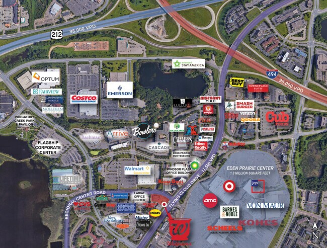

NEARBY LISTINGS FOR SALE OR LEASE
-
-
View all Eden Prairie listings for sale on LoopNet.com
Property Detail
8240 Flying Cloud Dr
Minneapolis-St. Paul-Bloomington, MN-WI
The Preserve Commercial Pk N 5Th Addn
14-116-22-31-0051
LOT 001 BLOCK 001 A THE PRESERVE COMMERCIAL PK N 5TH ADDN IRREGULAR
Commercialnec
Hennepin
X
Minnesota
27053C0435F
1
2024
1.05 AC
2024
Eden Prairie
026019
Minneapolis/St Paul
14,118 SF
DEMOGRAPHICS near 8240 Flying Cloud Dr
1 Mile
3 Mile
5 Mile
2024 Total Population
9,606
51,961
146,650
2029 Population
9,542
51,191
144,735
Pop Growth 2024-2029
(0.67%)
(1.48%)
(1.31%)
Average Age
37
41
42
2024 Total Households
4,242
21,168
60,738
HH Growth 2024-2029
(0.80%)
(1.60%)
(1.40%)
Median Household Inc
$90,022
$107,813
$107,623
Avg Household Size
2.20
2.40
2.30
2024 Avg HH Vehicles
1.00
2.00
2.00
Median Home Value
$327,853
$421,673
$428,200
Median Year Built
1989
1985
1981
Nearby Places
Map Layers
Map Styles
 Street
 Aerial
- Restaurants
- Banks
- Shops
- Fitness
- Groceries
PUBLIC TRANSPORTATION
AIRPORT
Minneapolis-St Paul International/Wold-Chamberlain
DRIVE
WALK
Distance
Minneapolis-St Paul International/Wold-Chamberlain
19 min
12.2 mi
Freight Ports
Port Milwaukee
DRIVE
WALK
Distance
Port Milwaukee
387 min
349.3 mi
SALE & LEASE HISTORY
LISTING DATE
SALE/LEASE

Aug 29, 2019
For Sale
Aug 03, 2017
For Sale
Apr 20, 2021
For Sale
Nearby Properties
Address
Land Use
TOTAL SIZE
Lot Size
Zoning
Address
Land Use
TOTAL SIZE
Lot Size
Zoning
49,799 SF
4.96 AC
Address
Land Use
TOTAL SIZE
Lot Size
Zoning
7.68 AC
Address
Land Use
TOTAL SIZE
Lot Size
Zoning
4.89 AC
Address
Land Use
TOTAL SIZE
Lot Size
Zoning
Address
Land Use
TOTAL SIZE
Lot Size
Zoning
49,757 SF
2.88 AC
Address
Land Use
TOTAL SIZE
Lot Size
Zoning
3.07 AC
Address
Land Use
TOTAL SIZE
Lot Size
Zoning
138,997 SF
14.03 AC
OFC
Address
Land Use
TOTAL SIZE
Lot Size
Zoning
136,782 SF
6.17 AC
Address
Land Use
TOTAL SIZE
Lot Size
Zoning
3.15 AC
Address
Land Use
TOTAL SIZE
Lot Size
Zoning
216,984 SF
14.48 AC
RM25
Address
Land Use
TOTAL SIZE
Lot Size
Zoning
93,982 SF
9.33 AC
OFC
Address
Land Use
TOTAL SIZE
Lot Size
Zoning
226,252 SF
5.40 AC
Address
Land Use
TOTAL SIZE
Lot Size
Zoning
175,506 SF
14.32 AC
Address
Land Use
TOTAL SIZE
Lot Size
Zoning
10.01 AC
RM25
Address
Land Use
TOTAL SIZE
Lot Size
Zoning
314,234 SF
2.31 AC
RM25
Address
Land Use
TOTAL SIZE
Lot Size
Zoning
327,536 SF
4.76 AC
CCOM
Address
Land Use
TOTAL SIZE
Lot Size
Zoning
166,989 SF
9.70 AC
RM25
Address
Land Use
TOTAL SIZE
Lot Size
Zoning
181,201 SF
8.30 AC
OFC
Address
Land Use
TOTAL SIZE
Lot Size
Zoning
122,801 SF
8.41 AC
RM25
Address
Land Use
TOTAL SIZE
Lot Size
Zoning
88,213 SF
3.77 AC
Address
Land Use
TOTAL SIZE
Lot Size
Zoning
9.94 AC
RM25
Address
Land Use
TOTAL SIZE
Lot Size
Zoning
12.57 AC
RM25
Address
Land Use
TOTAL SIZE
Lot Size
Zoning
7.30 AC
RM25
Address
Land Use
TOTAL SIZE
Lot Size
Zoning
5.77 AC
RM25
Address
Land Use
TOTAL SIZE
Lot Size
Zoning
325,341 SF
35.31 AC
C-REG
Address
Land Use
TOTAL SIZE
Lot Size
Zoning
298,582 SF
31.71 AC
OFC
Address
Land Use
TOTAL SIZE
Lot Size
Zoning
107,652 SF
9.82 AC
OFC
Address
Land Use
TOTAL SIZE
Lot Size
Zoning
130,990 SF
18.27 AC
C-REG
Address
Land Use
TOTAL SIZE
Lot Size
Zoning
8.38 AC
PUD
Address
Land Use
TOTAL SIZE
Lot Size
Zoning
536,598 SF
53.84 AC
I-5
The World's #1 Commercial Real Estate Marketplace
Connect with us
© 2025 CoStar Group
The information above has been obtained from sources believed reliable. While we do not doubt its accuracy we have not verified it and make no guarantee, warranty or representation about it. It is your responsibility to independently confirm its accuracy and completeness. Any projections, opinions, assumptions, or estimates used are for example only and do not represent the current or future performance of the property. The value of this transaction to you depends on tax and other factors which should be evaluated by your tax, financial, and legal advisors. You and your advisors should conduct a careful, independent investigation of the property to determine to your satisfaction the suitability of the property for your needs.