Property Record
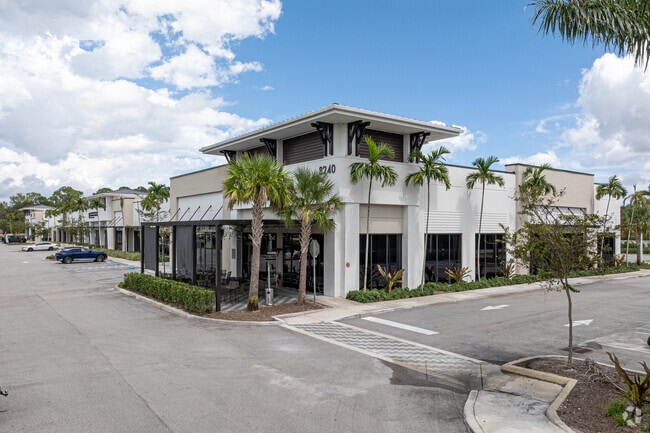
8240 S State Road 7, Boynton Beach, FL 33472


Current Lease Availabilities
NEARBY LISTINGS FOR SALE OR LEASE
Property Detail
8240 S State Road 7
00-42-45-18-14-001-0000
Melrose Pud
Storemultistory
MELROSE PUD COMMERCIAL TR A K/A FUTURE DEVELOPMENT
X
Palm Beach
12099C0765F
Florida
2024
4.94 AC
2025
Boynton/Lantana
007779
South Florida
38,306 SF
West Palm Beach-Boca Raton-Delray Beach, FL
DEMOGRAPHICS near 8240 S State Road 7
1 Mile
3 Mile
5 Mile
2024 Total Population
3,590
30,911
111,590
2029 Population
3,664
31,497
114,141
Pop Growth 2024-2029
+ 2.06%
+ 1.90%
+ 2.29%
Average Age
46
52
48
2024 Total Households
1,305
12,346
43,060
HH Growth 2024-2029
+ 1.46%
+ 1.25%
+ 1.80%
Median Household Inc
$98,052
$92,770
$93,337
Avg Household Size
2.60
2.40
2.50
2024 Avg HH Vehicles
2.00
2.00
2.00
Median Home Value
$466,095
$427,173
$405,178
Median Year Built
2005
2002
1997
Nearby Places
Map Layers
Map Styles
 Street
 Aerial
- Restaurants
- Banks
- Shops
- Fitness
- Groceries
PUBLIC TRANSPORTATION
AIRPORT
Palm Beach International
DRIVE
WALK
Distance
Palm Beach International
25 min
15.8 mi
Fort Lauderdale/Hollywood International
DRIVE
WALK
Distance
Fort Lauderdale/Hollywood International
56 min
40.1 mi
Nearby Properties
Address
Land Use
TOTAL SIZE
Lot Size
Zoning
Address
Land Use
TOTAL SIZE
Lot Size
Zoning
259,086 SF
44.59 AC
MUPD
Address
Land Use
TOTAL SIZE
Lot Size
Zoning
410,663 SF
22.50 AC
PUD
Address
Land Use
TOTAL SIZE
Lot Size
Zoning
298,137 SF
17.93 AC
PUD
Address
Land Use
TOTAL SIZE
Lot Size
Zoning
271,613 SF
33 AC
MUPD/P
Address
Land Use
TOTAL SIZE
Lot Size
Zoning
161,858 SF
19.49 AC
MUPD
Address
Land Use
TOTAL SIZE
Lot Size
Zoning
671,429 SF
245.66 AC
AGRPUD/P
Address
Land Use
TOTAL SIZE
Lot Size
Zoning
88,456 SF
10.85 AC
MUPD
Address
Land Use
TOTAL SIZE
Lot Size
Zoning
95,440 SF
6.74 AC
PUD
Address
Land Use
TOTAL SIZE
Lot Size
Zoning
88,125 SF
13.92 AC
AGR
Address
Land Use
TOTAL SIZE
Lot Size
Zoning
4,488 SF
52.12 AC
MUPD/P
Address
Land Use
TOTAL SIZE
Lot Size
Zoning
178,135 SF
21.23 AC
MUPD
Address
Land Use
TOTAL SIZE
Lot Size
Zoning
4,800 SF
39.40 AC
MUPD/P
Address
Land Use
TOTAL SIZE
Lot Size
Zoning
97,182 SF
77.58 AC
IPF
Address
Land Use
TOTAL SIZE
Lot Size
Zoning
67,907 SF
0.68 AC
MUPD
Address
Land Use
TOTAL SIZE
Lot Size
Zoning
110,195 SF
5.99 AC
MUPD
Address
Land Use
TOTAL SIZE
Lot Size
Zoning
72,299 SF
10.76 AC
MUPD
Address
Land Use
TOTAL SIZE
Lot Size
Zoning
55.61 AC
AR
Address
Land Use
TOTAL SIZE
Lot Size
Zoning
49,708 SF
4.24 AC
MUPD
Address
Land Use
TOTAL SIZE
Lot Size
Zoning
10,771 SF
313.30 AC
AR
Address
Land Use
TOTAL SIZE
Lot Size
Zoning
73,848 SF
4.85 AC
IL
Address
Land Use
TOTAL SIZE
Lot Size
Zoning
119,790 SF
2.63 AC
CG
Address
Land Use
TOTAL SIZE
Lot Size
Zoning
36,214 SF
10.80 AC
MUPD
Address
Land Use
TOTAL SIZE
Lot Size
Zoning
37,066 SF
4.76 AC
MUPD
Address
Land Use
TOTAL SIZE
Lot Size
Zoning
7,200 SF
40.15 AC
AGR
Address
Land Use
TOTAL SIZE
Lot Size
Zoning
48,244 SF
5.10 AC
RT
Address
Land Use
TOTAL SIZE
Lot Size
Zoning
50,915 SF
5.97 AC
MUPD
Address
Land Use
TOTAL SIZE
Lot Size
Zoning
25,432 SF
9.23 AC
AGR
Address
Land Use
TOTAL SIZE
Lot Size
Zoning
24,864 SF
6.98 AC
MUPD
Address
Land Use
TOTAL SIZE
Lot Size
Zoning
7,040 SF
33.63 AC
PUD
The World's #1 Commercial Real Estate Marketplace
Connect with us
© 2026 CoStar Group
The information above has been obtained from sources believed reliable. While we do not doubt its accuracy we have not verified it and make no guarantee, warranty or representation about it. It is your responsibility to independently confirm its accuracy and completeness. Any projections, opinions, assumptions, or estimates used are for example only and do not represent the current or future performance of the property. The value of this transaction to you depends on tax and other factors which should be evaluated by your tax, financial, and legal advisors. You and your advisors should conduct a careful, independent investigation of the property to determine to your satisfaction the suitability of the property for your needs.