Property Record
8242 Ne State Highway 104, Kingston, WA 98346

NEARBY LISTINGS FOR SALE OR LEASE
-
-
View all Kingston listings for sale on LoopNet.com
Property Detail
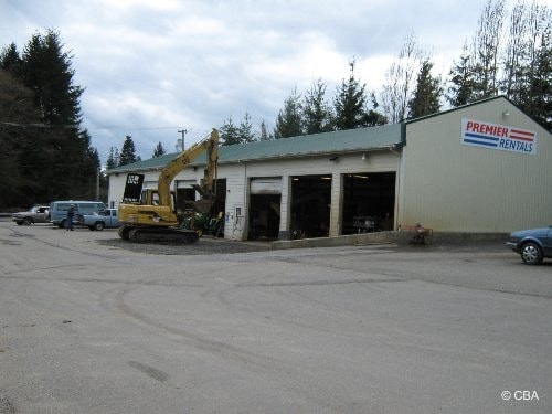
8242 Ne State Highway 104
Bremerton-Silverdale, WA
Bsp 99-18
222702-3-039-2006
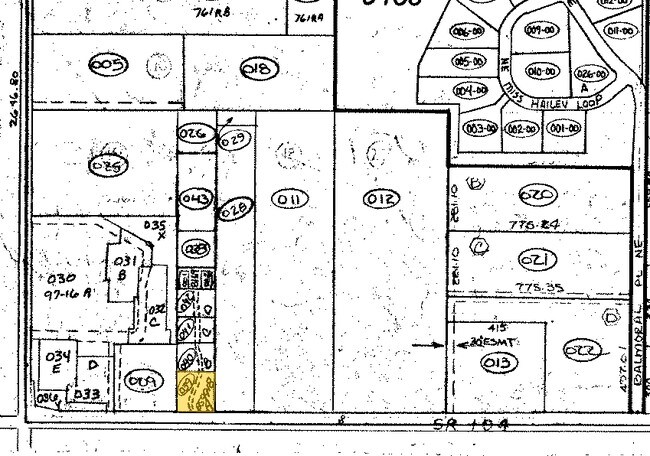
LOT A BINDING SITE PLAN NO. 99-18 RECORDED UNDER AUDITORS FILE NO. 3186087, IN VOLUME 15 PAGE 148 OF SHORT PLATS. THE WEST HALF OF THE WEST HALF OF THE EAST HALF OF THE SOUTHWEST QUARTER OF THE SOUTHWEST QUARTER, SECTION 22, TOWNSHIP 27 NORTH, RANGE
Commercialnec
Kitsap
X
Washington
53031C0970C
a
2025
0.70 AC
2026
North Kitsap County
090102
Bremerton/Silverdale
4,960 SF
DEMOGRAPHICS near 8242 Ne State Highway 104
1 Mile
3 Mile
5 Mile
2024 Total Population
685
7,037
16,089
2029 Population
680
6,964
15,875
Pop Growth 2024-2029
(0.73%)
(1.04%)
(1.33%)
Average Age
44
44
45
2024 Total Households
268
2,786
6,376
HH Growth 2024-2029
(0.75%)
(1.04%)
(1.33%)
Median Household Inc
$99,264
$103,834
$96,439
Avg Household Size
2.50
2.40
2.50
2024 Avg HH Vehicles
2.00
2.00
2.00
Median Home Value
$643,885
$638,444
$593,458
Median Year Built
1988
1988
1988
Nearby Places
Map Layers
Map Styles
 Street
 Aerial
- Restaurants
- Banks
- Shops
- Fitness
- Groceries
PUBLIC TRANSPORTATION
COMMUTER RAIL
Edmonds Station (Sounder South Line - Central Puget Sound Regional Transit Authority Rail (Link Light Rail/Sounder))
DRIVE
WALK
Distance
Edmonds Station (Sounder South Line - Central Puget Sound Regional Transit Authority Rail (Link Light Rail/Sounder))
32 min
8.4 mi
AIRPORT
Seattle Paine Field International
DRIVE
WALK
Distance
Seattle Paine Field International
54 min
19.3 mi
Seattle-Tacoma International
DRIVE
WALK
Distance
Seattle-Tacoma International
79 min
39.2 mi
Freight Ports
Port of Seattle
DRIVE
WALK
Distance
Port of Seattle
66 min
29.7 mi
Nearby Properties
Address
Land Use
TOTAL SIZE
Lot Size
Zoning
Address
Land Use
TOTAL SIZE
Lot Size
Zoning
72,735 SF
5.72 AC
UH
Address
Land Use
TOTAL SIZE
Lot Size
Zoning
52,060 SF
15.70 AC
RR
Address
Land Use
TOTAL SIZE
Lot Size
Zoning
55.02 AC
RRUCR
Address
Land Use
TOTAL SIZE
Lot Size
Zoning
1,510 SF
5.15 AC
REC
Address
Land Use
TOTAL SIZE
Lot Size
Zoning
41,892 SF
4.58 AC
NC
Address
Land Use
TOTAL SIZE
Lot Size
Zoning
32,440 SF
3.91 AC
REC
Address
Land Use
TOTAL SIZE
Lot Size
Zoning
33,232 SF
3.44 AC
C
Address
Land Use
TOTAL SIZE
Lot Size
Zoning
29,570 SF
4.89 AC
UL
Address
Land Use
TOTAL SIZE
Lot Size
Zoning
22,879 SF
2.99 AC
C
Address
Land Use
TOTAL SIZE
Lot Size
Zoning
7,092 SF
0.90 AC
UM
Address
Land Use
TOTAL SIZE
Lot Size
Zoning
15,414 SF
1.49 AC
UM
Address
Land Use
TOTAL SIZE
Lot Size
Zoning
17,664 SF
2.11 AC
UL
Address
Land Use
TOTAL SIZE
Lot Size
Zoning
18,187 SF
2.16 AC
NC
Address
Land Use
TOTAL SIZE
Lot Size
Zoning
9,933 SF
0.98 AC
NC
Address
Land Use
TOTAL SIZE
Lot Size
Zoning
57,386 SF
7.70 AC
REC
Address
Land Use
TOTAL SIZE
Lot Size
Zoning
9,750 SF
1.11 AC
NC
Address
Land Use
TOTAL SIZE
Lot Size
Zoning
30,755 SF
1.15 AC
NC
Address
Land Use
TOTAL SIZE
Lot Size
Zoning
5.90 AC
REC
Address
Land Use
TOTAL SIZE
Lot Size
Zoning
22,400 SF
4.11 AC
REC
Address
Land Use
TOTAL SIZE
Lot Size
Zoning
9,064 SF
15.07 AC
RR
Address
Land Use
TOTAL SIZE
Lot Size
Zoning
6,450 SF
0.90 AC
NC
Address
Land Use
TOTAL SIZE
Lot Size
Zoning
10,560 SF
0.85 AC
REC
Address
Land Use
TOTAL SIZE
Lot Size
Zoning
5,327 SF
31.03 AC
RP
Address
Land Use
TOTAL SIZE
Lot Size
Zoning
14,436 SF
1.18 AC
C
Address
Land Use
TOTAL SIZE
Lot Size
Zoning
2,705 SF
1.59 AC
C
Address
Land Use
TOTAL SIZE
Lot Size
Zoning
5,027 SF
16.56 AC
RR
Address
Land Use
TOTAL SIZE
Lot Size
Zoning
2,654 SF
0.76 AC
C
Address
Land Use
TOTAL SIZE
Lot Size
Zoning
10,979 SF
0.38 AC
UVC
Address
Land Use
TOTAL SIZE
Lot Size
Zoning
4,317 SF
2 AC
RP
Address
Land Use
TOTAL SIZE
Lot Size
Zoning
4,200 SF
1.32 AC
NC
The World's #1 Commercial Real Estate Marketplace
Connect with us
© 2025 CoStar Group
The information above has been obtained from sources believed reliable. While we do not doubt its accuracy we have not verified it and make no guarantee, warranty or representation about it. It is your responsibility to independently confirm its accuracy and completeness. Any projections, opinions, assumptions, or estimates used are for example only and do not represent the current or future performance of the property. The value of this transaction to you depends on tax and other factors which should be evaluated by your tax, financial, and legal advisors. You and your advisors should conduct a careful, independent investigation of the property to determine to your satisfaction the suitability of the property for your needs.