Property Record
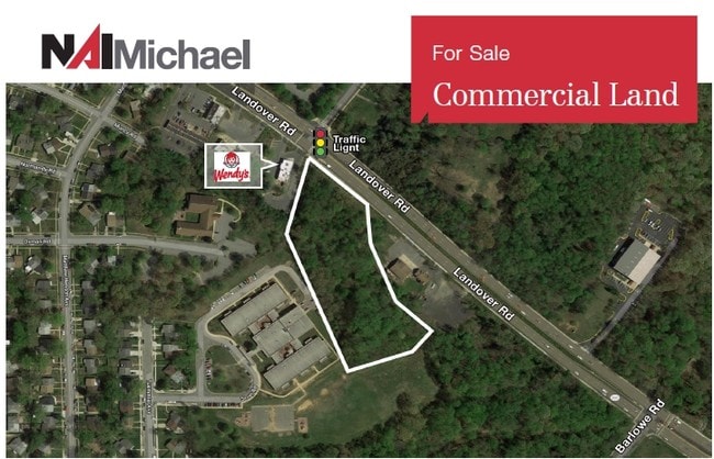
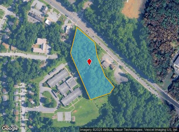
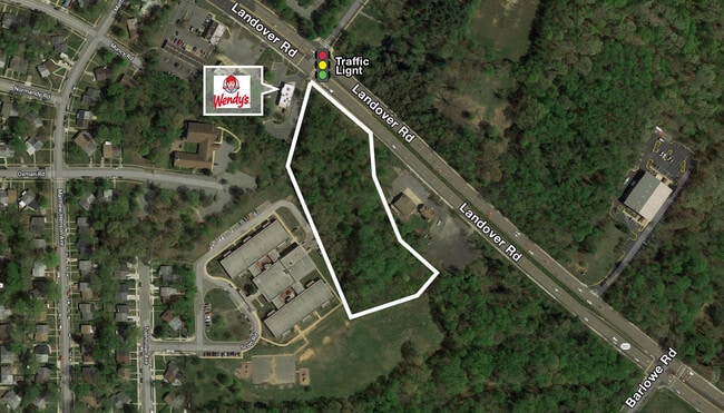
8247 Landover Rd, Hyattsville, MD 20785

This Property Is For Sale
NEARBY LISTINGS FOR SALE OR LEASE
Property Detail
8247 Landover Rd
13-1557313
Palmer Park
Commercialnec
Prince George's
X
Maryland
24033C0165E
3.71 AC
2024
Landover/Largo/Captl Hts
2025
Washington, DC
803403
Washington-Arlington-Alexandria, DC-VA-MD-WV
DEMOGRAPHICS near 8247 Landover Rd
1 Mile
3 Mile
5 Mile
2024 Total Population
17,908
123,877
339,250
2029 Population
17,713
121,219
328,222
Pop Growth 2024-2029
(1.09%)
(2.15%)
(3.25%)
Average Age
37
39
39
2024 Total Households
5,954
43,861
119,359
HH Growth 2024-2029
(1.34%)
(2.19%)
(3.59%)
Median Household Inc
$59,014
$80,527
$78,900
Avg Household Size
3.00
2.80
2.80
2024 Avg HH Vehicles
2.00
2.00
2.00
Median Home Value
$282,950
$337,162
$357,885
Median Year Built
1969
1975
1972
Nearby Places
- Restaurants
- Banks
- Shops
- Fitness
- Groceries
PUBLIC TRANSPORTATION
COMMUTER RAIL
New Carrollton Marc Nb (PENN - WASHINGTON - Maryland Transit Administration)
DRIVE
WALK
Distance
New Carrollton Marc Nb (PENN - WASHINGTON - Maryland Transit Administration)
9 min
5.7 mi
New Carrollton (PENN - WASHINGTON - Maryland Area Regional Commuter Trains (The MARC), Penn Line - Maryland Area Regional Commuter Trains (The MARC))
DRIVE
WALK
Distance
New Carrollton (PENN - WASHINGTON - Maryland Area Regional Commuter Trains (The MARC), Penn Line - Maryland Area Regional Commuter Trains (The MARC))
9 min
5.7 mi
AIRPORT
Ronald Reagan Washington Ntl
DRIVE
WALK
Distance
Ronald Reagan Washington Ntl
24 min
15.3 mi
Baltimore/Washington International Thurgood Marshall
DRIVE
WALK
Distance
Baltimore/Washington International Thurgood Marshall
39 min
26.9 mi
Freight Ports
Port of Baltimore
DRIVE
WALK
Distance
Port of Baltimore
49 min
33.5 mi
Nearby Properties
Address
Land Use
TOTAL SIZE
Lot Size
Zoning
Address
Land Use
TOTAL SIZE
Lot Size
Zoning
1,631,415 SF
24.33 AC
RTOHC
Address
Land Use
TOTAL SIZE
Lot Size
Zoning
35.03 AC
LTOE
Address
Land Use
TOTAL SIZE
Lot Size
Zoning
177,081 SF
23.22 AC
LCD
Address
Land Use
TOTAL SIZE
Lot Size
Zoning
944,105 SF
23.09 AC
CGO
Address
Land Use
TOTAL SIZE
Lot Size
Zoning
413,915 SF
39.86 AC
IE
Address
Land Use
TOTAL SIZE
Lot Size
Zoning
5.10 AC
RTOHC
Address
Land Use
TOTAL SIZE
Lot Size
Zoning
12.60 AC
LTOC
Address
Land Use
TOTAL SIZE
Lot Size
Zoning
337,216 SF
1.18 AC
RTOHC
Address
Land Use
TOTAL SIZE
Lot Size
Zoning
821,240 SF
48.32 AC
IH
Address
Land Use
TOTAL SIZE
Lot Size
Zoning
7.72 AC
CGO
Address
Land Use
TOTAL SIZE
Lot Size
Zoning
100 SF
4.78 AC
RTOHC
Address
Land Use
TOTAL SIZE
Lot Size
Zoning
315 SF
6.62 AC
RTOHE
Address
Land Use
TOTAL SIZE
Lot Size
Zoning
1,082,460 SF
9.28 AC
RTOHC
Address
Land Use
TOTAL SIZE
Lot Size
Zoning
379,168 SF
18.94 AC
RMF20
Address
Land Use
TOTAL SIZE
Lot Size
Zoning
456,950 SF
52.92 AC
CGO
Address
Land Use
TOTAL SIZE
Lot Size
Zoning
2.35 AC
RTOHC
Address
Land Use
TOTAL SIZE
Lot Size
Zoning
344 SF
23.70 AC
RMF12
Address
Land Use
TOTAL SIZE
Lot Size
Zoning
327,240 SF
1.72 AC
RTOHC
Address
Land Use
TOTAL SIZE
Lot Size
Zoning
182,907 SF
39.78 AC
RR
Address
Land Use
TOTAL SIZE
Lot Size
Zoning
491,397 SF
6.20 AC
RTOHE
Address
Land Use
TOTAL SIZE
Lot Size
Zoning
368,038 SF
12.87 AC
IE
Address
Land Use
TOTAL SIZE
Lot Size
Zoning
4,704 SF
7.20 AC
RMF48
Address
Land Use
TOTAL SIZE
Lot Size
Zoning
217,500 SF
12.95 AC
RTOHE
Address
Land Use
TOTAL SIZE
Lot Size
Zoning
194,850 SF
8.90 AC
LTOE
Address
Land Use
TOTAL SIZE
Lot Size
Zoning
34.38 AC
RMF12
Address
Land Use
TOTAL SIZE
Lot Size
Zoning
14.36 AC
RMF48
Address
Land Use
TOTAL SIZE
Lot Size
Zoning
2.09 AC
RTOHC
Address
Land Use
TOTAL SIZE
Lot Size
Zoning
218,628 SF
1.45 AC
RTOHC
Address
Land Use
TOTAL SIZE
Lot Size
Zoning
300,000 SF
2.82 AC
RTOHC
Address
Land Use
TOTAL SIZE
Lot Size
Zoning
169,431 SF
43.81 AC
CGO
The World's #1 Commercial Real Estate Marketplace
Connect with us
© 2025 CoStar Group
The information above has been obtained from sources believed reliable. While we do not doubt its accuracy we have not verified it and make no guarantee, warranty or representation about it. It is your responsibility to independently confirm its accuracy and completeness. Any projections, opinions, assumptions, or estimates used are for example only and do not represent the current or future performance of the property. The value of this transaction to you depends on tax and other factors which should be evaluated by your tax, financial, and legal advisors. You and your advisors should conduct a careful, independent investigation of the property to determine to your satisfaction the suitability of the property for your needs.