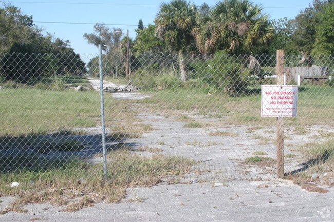
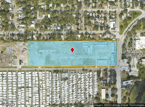
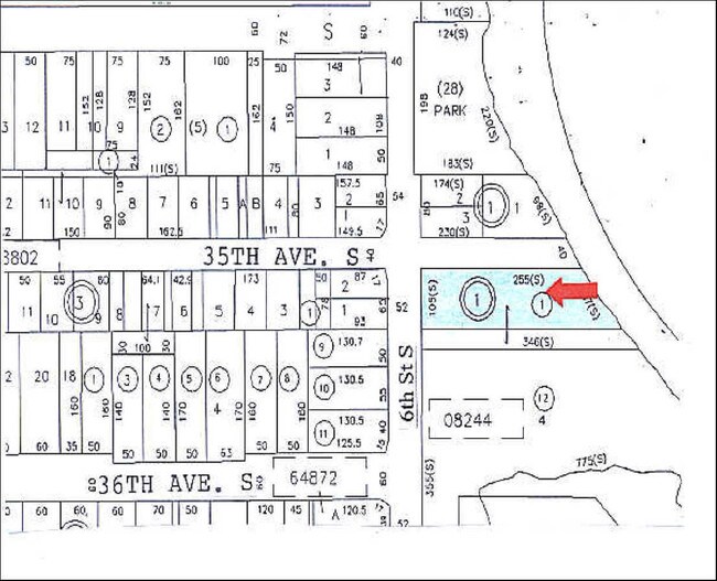
Property Record
825 32Nd Ave S, Saint Petersburg, FL 33705
NEARBY LISTINGS FOR SALE OR LEASE
Property Detail
825 32Nd Ave S
Tampa-St. Petersburg-Clearwater, FL
Bentons Sub
31-31-17-08244-000-0101
BENTONS SUB PART OF LOT 1 DESC AS FROM NW COR OF SW 1/4 OF SEC 31-31-17 TH S00D1057W 117FT TH N89D5537E 498.34FT FOR POB TH N89D 5537E 1307.56FT TH S00D 3031W 367.42FT TH S89D 5729W 1303.63FT TH N00D 0423W 366.69 TO POB
Apartment
Pinellas
AE
Florida
12103C0282H
1
2024
10.98 AC
2025
Tropical Shores
020301
Tampa/St Petersburg
309,385 SF
DEMOGRAPHICS near 825 32Nd Ave S
1 Mile
3 Mile
5 Mile
2024 Total Population
11,948
81,180
162,924
2029 Population
12,067
82,070
164,007
Pop Growth 2024-2029
+ 1.00%
+ 1.10%
+ 0.66%
Average Age
41
43
44
2024 Total Households
5,009
37,796
75,203
HH Growth 2024-2029
+ 0.90%
+ 0.98%
+ 0.55%
Median Household Inc
$62,098
$57,836
$64,575
Avg Household Size
2.20
2.00
2.00
2024 Avg HH Vehicles
2.00
1.00
2.00
Median Home Value
$272,251
$332,331
$320,171
Median Year Built
1956
1969
1963
Nearby Places
- Restaurants
- Banks
- Shops
- Fitness
- Groceries
PUBLIC TRANSPORTATION
AIRPORT
St Pete-Clearwater International
DRIVE
WALK
Distance
St Pete-Clearwater International
28 min
15.1 mi
Tampa International
DRIVE
WALK
Distance
Tampa International
35 min
23.8 mi
Sarasota/Bradenton International
DRIVE
WALK
Distance
Sarasota/Bradenton International
48 min
31.1 mi
Freight Ports
Port Manatee
DRIVE
WALK
Distance
Port Manatee
34 min
23.6 mi
Nearby Properties
Address
Land Use
TOTAL SIZE
Lot Size
Zoning
Address
Land Use
TOTAL SIZE
Lot Size
Zoning
725,000 SF
6.05 AC
Address
Land Use
TOTAL SIZE
Lot Size
Zoning
221,003 SF
1.39 AC
Address
Land Use
TOTAL SIZE
Lot Size
Zoning
662,311 SF
2.89 AC
Address
Land Use
TOTAL SIZE
Lot Size
Zoning
655,966 SF
1.25 AC
Address
Land Use
TOTAL SIZE
Lot Size
Zoning
687,948 SF
2.86 AC
Address
Land Use
TOTAL SIZE
Lot Size
Zoning
690,001 SF
2.28 AC
Address
Land Use
TOTAL SIZE
Lot Size
Zoning
1,100,000 SF
57.70 AC
Address
Land Use
TOTAL SIZE
Lot Size
Zoning
287,275 SF
6.29 AC
Address
Land Use
TOTAL SIZE
Lot Size
Zoning
807,604 SF
9.61 AC
Address
Land Use
TOTAL SIZE
Lot Size
Zoning
593,859 SF
2.04 AC
Address
Land Use
TOTAL SIZE
Lot Size
Zoning
593,733 SF
4.35 AC
Address
Land Use
TOTAL SIZE
Lot Size
Zoning
399,617 SF
13.08 AC
Address
Land Use
TOTAL SIZE
Lot Size
Zoning
596,429 SF
8.07 AC
Address
Land Use
TOTAL SIZE
Lot Size
Zoning
474,605 SF
1.84 AC
Address
Land Use
TOTAL SIZE
Lot Size
Zoning
850,770 SF
92.67 AC
Address
Land Use
TOTAL SIZE
Lot Size
Zoning
547,258 SF
3.24 AC
Address
Land Use
TOTAL SIZE
Lot Size
Zoning
443,983 SF
0.88 AC
Address
Land Use
TOTAL SIZE
Lot Size
Zoning
231,140 SF
5.10 AC
Address
Land Use
TOTAL SIZE
Lot Size
Zoning
193,444 SF
2,339.19 AC
Address
Land Use
TOTAL SIZE
Lot Size
Zoning
402,572 SF
10.02 AC
Address
Land Use
TOTAL SIZE
Lot Size
Zoning
242,915 SF
2.20 AC
Address
Land Use
TOTAL SIZE
Lot Size
Zoning
348,400 SF
1.89 AC
Address
Land Use
TOTAL SIZE
Lot Size
Zoning
366,959 SF
2.02 AC
Address
Land Use
TOTAL SIZE
Lot Size
Zoning
512,449 SF
6.01 AC
Address
Land Use
TOTAL SIZE
Lot Size
Zoning
457,983 SF
3.86 AC
Address
Land Use
TOTAL SIZE
Lot Size
Zoning
431,739 SF
3.29 AC
Address
Land Use
TOTAL SIZE
Lot Size
Zoning
393,952 SF
Address
Land Use
TOTAL SIZE
Lot Size
Zoning
568,794 SF
23.72 AC
Address
Land Use
TOTAL SIZE
Lot Size
Zoning
341,472 SF
29.42 AC
The World's #1 Commercial Real Estate Marketplace
Connect with us
© 2025 CoStar Group
The information above has been obtained from sources believed reliable. While we do not doubt its accuracy we have not verified it and make no guarantee, warranty or representation about it. It is your responsibility to independently confirm its accuracy and completeness. Any projections, opinions, assumptions, or estimates used are for example only and do not represent the current or future performance of the property. The value of this transaction to you depends on tax and other factors which should be evaluated by your tax, financial, and legal advisors. You and your advisors should conduct a careful, independent investigation of the property to determine to your satisfaction the suitability of the property for your needs.