Property Record
825 Morgantown Rd, Reading, PA 19607
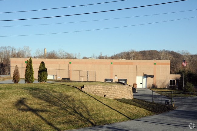

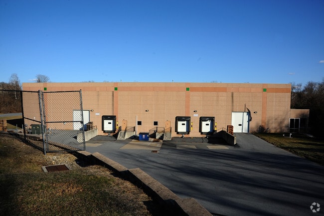
Property Detail
825 Morgantown Rd
18-5306-20-91-6265
Berks
Warehouse
Pennsylvania
AE The base floodplain where base flood elevations are provided. AE Zones are now used on new format FIRMs instead of A1-A30 Zones.
6.73 AC
2025
Berks
2025
Philadelphia
002900
Reading, PA
78,648 SF
NEARBY LISTINGS FOR SALE OR LEASE
DEMOGRAPHICS near 825 Morgantown Rd
1 mile
3 mile
5 mile
2025 Total Population
5,099
119,545
202,635
2030 Population
5,226
121,721
206,564
Pop Growth 2025-2030
+ 2.49%
+ 1.82%
+ 1.94%
Average Age
37
38
39
2025 Total Households
1,598
44,080
75,498
HH Growth 2025-2030
+ 2.07%
+ 1.86%
+ 1.98%
Median Household Inc
$64,455
$56,362
$64,110
Avg Household Size
2.40
2.60
2.50
2025 Avg HH Vehicles
2.00
1.00
2.00
Median Home Value
$179,921
$175,476
$217,540
Median Year Built
1949
1949
1958
Nearby Places
Map Layers
Map Styles
 Street
 Aerial
Transit
 Traffic
 Biking
Places
Listings with unknown addresses are not visible on the map
- Restaurants
- Banks
- Shops
- Fitness
- Groceries
Nearby Properties
Address
Land Use
TOTAL SIZE
Lot Size
Zoning
Address
Land Use
TOTAL SIZE
Lot Size
Zoning
732,361 SF
110.76 AC
Address
Land Use
TOTAL SIZE
Lot Size
Zoning
33,761 SF
4.38 AC
Address
Land Use
TOTAL SIZE
Lot Size
Zoning
392,251 SF
78.10 AC
Address
Land Use
TOTAL SIZE
Lot Size
Zoning
342,332 SF
3.30 AC
Address
Land Use
TOTAL SIZE
Lot Size
Zoning
144,696 SF
7.43 AC
Address
Land Use
TOTAL SIZE
Lot Size
Zoning
88,576 SF
1.80 AC
Address
Land Use
TOTAL SIZE
Lot Size
Zoning
130,410 SF
23.02 AC
Address
Land Use
TOTAL SIZE
Lot Size
Zoning
138,752 SF
21.81 AC
Address
Land Use
TOTAL SIZE
Lot Size
Zoning
20,731 SF
28.51 AC
Address
Land Use
TOTAL SIZE
Lot Size
Zoning
71,271 SF
1.42 AC
Address
Land Use
TOTAL SIZE
Lot Size
Zoning
310,014 SF
15.02 AC
Address
Land Use
TOTAL SIZE
Lot Size
Zoning
174,046 SF
6.92 AC
Address
Land Use
TOTAL SIZE
Lot Size
Zoning
62,907 SF
5.25 AC
Address
Land Use
TOTAL SIZE
Lot Size
Zoning
163,466 SF
19.19 AC
Address
Land Use
TOTAL SIZE
Lot Size
Zoning
188,801 SF
14.41 AC
Address
Land Use
TOTAL SIZE
Lot Size
Zoning
66,610 SF
5.38 AC
Address
Land Use
TOTAL SIZE
Lot Size
Zoning
27,055 SF
1.77 AC
Address
Land Use
TOTAL SIZE
Lot Size
Zoning
104,304 SF
9.77 AC
Address
Land Use
TOTAL SIZE
Lot Size
Zoning
295,427 SF
9.71 AC
Address
Land Use
TOTAL SIZE
Lot Size
Zoning
204,844 SF
16.33 AC
Address
Land Use
TOTAL SIZE
Lot Size
Zoning
57,750 SF
4.07 AC
Address
Land Use
TOTAL SIZE
Lot Size
Zoning
84,599 SF
28.56 AC
Address
Land Use
TOTAL SIZE
Lot Size
Zoning
20,481 SF
1.07 AC
Address
Land Use
TOTAL SIZE
Lot Size
Zoning
29,144 SF
2.85 AC
Address
Land Use
TOTAL SIZE
Lot Size
Zoning
66,770 SF
4.12 AC
Address
Land Use
TOTAL SIZE
Lot Size
Zoning
1,736,698 SF
28.54 AC
Address
Land Use
TOTAL SIZE
Lot Size
Zoning
76,773 SF
7.07 AC
Address
Land Use
TOTAL SIZE
Lot Size
Zoning
28,186 SF
1.87 AC
Address
Land Use
TOTAL SIZE
Lot Size
Zoning
88,472 SF
1.17 AC
Address
Land Use
TOTAL SIZE
Lot Size
Zoning
42,652 SF
1.41 AC
The World's #1 Commercial Real Estate Marketplace
Connect with us
© 2026 CoStar Group
The information above has been obtained from sources believed reliable. While we do not doubt its accuracy we have not verified it and make no guarantee, warranty or representation about it. It is your responsibility to independently confirm its accuracy and completeness. Any projections, opinions, assumptions, or estimates used are for example only and do not represent the current or future performance of the property. The value of this transaction to you depends on tax and other factors which should be evaluated by your tax, financial, and legal advisors. You and your advisors should conduct a careful, independent investigation of the property to determine to your satisfaction the suitability of the property for your needs.