Property Record
825 Stokes Landing Rd, Saint Augustine, FL 32095
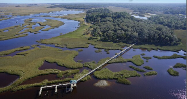

Property Detail
825 Stokes Landing Rd
Jacksonville, FL
3 GL 2 (EX 4AC DB156/149 1AC DB154/493 1.29AC OR419/208 1.27AC OR426/305 & 1.26AC OR448/576 & 1.29AC OR720/1308 & EX OR754/1704 & OR817/431 & OR819/257) OR2295/1185 & 2817/617(Q/C)
072370-0000
ST. JOHNS
Residentialacreage
Florida
OR
3
AE The base floodplain where base flood elevations are provided. AE Zones are now used on new format FIRMs instead of A1-A30 Zones.
10.53 AC
2025
St Johns County
2026
Jacksonville (Florida)
020904
NEARBY LISTINGS FOR SALE OR LEASE
DEMOGRAPHICS near 825 Stokes Landing Rd
1 mile
3 mile
5 mile
2025 Total Population
806
13,380
23,730
2030 Population
934
15,508
27,703
Pop Growth 2025-2030
+ 15.88%
+ 15.90%
+ 16.74%
Average Age
43
43
45
2025 Total Households
295
4,804
8,978
HH Growth 2025-2030
+ 16.27%
+ 16.38%
+ 17.22%
Median Household Inc
$109,797
$131,460
$131,263
Avg Household Size
2.70
2.70
2.60
2025 Avg HH Vehicles
2.00
2.00
2.00
Median Home Value
$716,836
$627,355
$675,966
Median Year Built
2006
2010
2010
Nearby Places
Map Layers
Map Styles
 Street
 Aerial
Layers
 Traffic
 Biking
Places
Listings with unknown addresses are not visible on the map
- Restaurants
- Banks
- Shops
- Fitness
- Groceries
SALE & LEASE HISTORY
LISTING DATE
SALE/LEASE

Mar 16, 2021
For Sale
Nearby Properties
Address
Land Use
TOTAL SIZE
Lot Size
Zoning
Address
Land Use
TOTAL SIZE
Lot Size
Zoning
102,311 SF
7.21 AC
PUD
Address
Land Use
TOTAL SIZE
Lot Size
Zoning
67,311 SF
7.28 AC
PUD
Address
Land Use
TOTAL SIZE
Lot Size
Zoning
15,250 SF
22.47 AC
Address
Land Use
TOTAL SIZE
Lot Size
Zoning
5.65 AC
CG
Address
Land Use
TOTAL SIZE
Lot Size
Zoning
Address
Land Use
TOTAL SIZE
Lot Size
Zoning
268.05 AC
Address
Land Use
TOTAL SIZE
Lot Size
Zoning
127.03 AC
Address
Land Use
TOTAL SIZE
Lot Size
Zoning
65.40 AC
Address
Land Use
TOTAL SIZE
Lot Size
Zoning
24,167 SF
12.90 AC
IW/OR
Address
Land Use
TOTAL SIZE
Lot Size
Zoning
3,356 SF
1.20 AC
Address
Land Use
TOTAL SIZE
Lot Size
Zoning
703 SF
4.41 AC
Address
Land Use
TOTAL SIZE
Lot Size
Zoning
21,579 SF
3.96 AC
PUD
Address
Land Use
TOTAL SIZE
Lot Size
Zoning
44,150 SF
2.75 AC
Address
Land Use
TOTAL SIZE
Lot Size
Zoning
8,018 SF
5.26 AC
IW
Address
Land Use
TOTAL SIZE
Lot Size
Zoning
Address
Land Use
TOTAL SIZE
Lot Size
Zoning
19,450 SF
6 AC
IW
Address
Land Use
TOTAL SIZE
Lot Size
Zoning
27,644 SF
3.34 AC
PUD
Address
Land Use
TOTAL SIZE
Lot Size
Zoning
7,200 SF
4.73 AC
CI
Address
Land Use
TOTAL SIZE
Lot Size
Zoning
30,065 SF
177.58 AC
OR
Address
Land Use
TOTAL SIZE
Lot Size
Zoning
3,060 SF
134.21 AC
PUD
Address
Land Use
TOTAL SIZE
Lot Size
Zoning
11,139 SF
2.75 AC
CI
Address
Land Use
TOTAL SIZE
Lot Size
Zoning
14,024 SF
1.82 AC
Address
Land Use
TOTAL SIZE
Lot Size
Zoning
9,350 SF
4.92 AC
IW
Address
Land Use
TOTAL SIZE
Lot Size
Zoning
12,868 SF
1.58 AC
DRI
Address
Land Use
TOTAL SIZE
Lot Size
Zoning
33.46 AC
OR
Address
Land Use
TOTAL SIZE
Lot Size
Zoning
9,706 SF
0.69 AC
PUD
Address
Land Use
TOTAL SIZE
Lot Size
Zoning
Address
Land Use
TOTAL SIZE
Lot Size
Zoning
3.49 AC
IW
Address
Land Use
TOTAL SIZE
Lot Size
Zoning
Address
Land Use
TOTAL SIZE
Lot Size
Zoning
5,346 SF
1.92 AC
PUD
The World's #1 Commercial Real Estate Marketplace
Connect with us
© 2026 CoStar Group
The information above has been obtained from sources believed reliable. While we do not doubt its accuracy we have not verified it and make no guarantee, warranty or representation about it. It is your responsibility to independently confirm its accuracy and completeness. Any projections, opinions, assumptions, or estimates used are for example only and do not represent the current or future performance of the property. The value of this transaction to you depends on tax and other factors which should be evaluated by your tax, financial, and legal advisors. You and your advisors should conduct a careful, independent investigation of the property to determine to your satisfaction the suitability of the property for your needs.