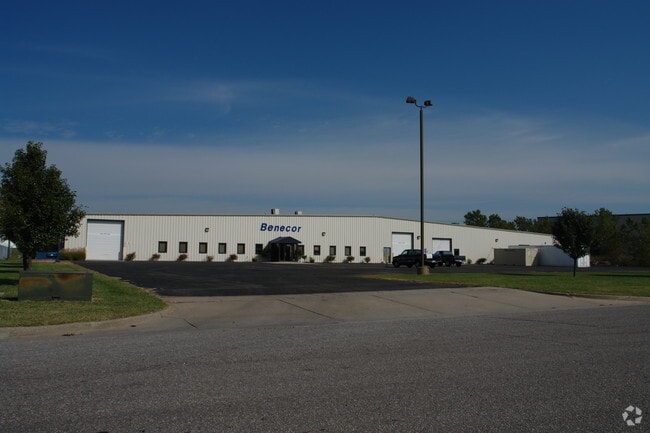
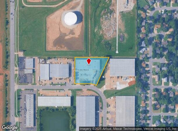
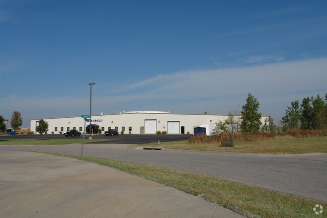
Property Record
8250 E Marion St, Wichita, KS 67210
NEARBY LISTINGS FOR SALE OR LEASE
Property Detail
8250 E Marion St
Wichita, KS
Oak Knoll Industrial Park Add
223-05-0-23-01-003.00
LOT 3 BLOCK 1 OAK KNOLL INDUSTRIAL PARK ADD.
Heavyindustrial
Sedgwick
X
Kansas
20173C0388G
3
2024
1.94 AC
2025
Southeast
010003
Wichita
25,064 SF
DEMOGRAPHICS near 8250 E Marion St
1 Mile
3 Mile
5 Mile
2024 Total Population
7,034
55,753
140,399
2029 Population
7,062
57,047
143,897
Pop Growth 2024-2029
+ 0.40%
+ 2.32%
+ 2.49%
Average Age
35
36
38
2024 Total Households
2,615
22,579
56,563
HH Growth 2024-2029
+ 0.42%
+ 2.29%
+ 2.42%
Median Household Inc
$64,206
$53,168
$55,148
Avg Household Size
2.50
2.40
2.40
2024 Avg HH Vehicles
2.00
2.00
2.00
Median Home Value
$170,296
$151,277
$156,423
Median Year Built
1987
1973
1967
Nearby Places
Map Layers
Map Styles
 Street
 Aerial
- Restaurants
- Banks
- Shops
- Fitness
- Groceries
PUBLIC TRANSPORTATION
AIRPORT
Wichita Dwight D Eisenhower Ntl
DRIVE
WALK
Distance
Wichita Dwight D Eisenhower Ntl
23 min
14.0 mi
Nearby Properties
Address
Land Use
TOTAL SIZE
Lot Size
Zoning
Address
Land Use
TOTAL SIZE
Lot Size
Zoning
310,946 SF
123.12 AC
SF-5
Address
Land Use
TOTAL SIZE
Lot Size
Zoning
418.47 AC
AFB
Address
Land Use
TOTAL SIZE
Lot Size
Zoning
527,510 SF
50.27 AC
TF-3
Address
Land Use
TOTAL SIZE
Lot Size
Zoning
167,304 SF
6.19 AC
MF-29
Address
Land Use
TOTAL SIZE
Lot Size
Zoning
152,978 SF
7.86 AC
LI
Address
Land Use
TOTAL SIZE
Lot Size
Zoning
3,063,858 SF
57.81 AC
LI
Address
Land Use
TOTAL SIZE
Lot Size
Zoning
728,346 SF
33.17 AC
LC
Address
Land Use
TOTAL SIZE
Lot Size
Zoning
72,183 SF
19.30 AC
SF-5
Address
Land Use
TOTAL SIZE
Lot Size
Zoning
106,159 SF
16.16 AC
SF-5
Address
Land Use
TOTAL SIZE
Lot Size
Zoning
54,975 SF
13.80 AC
GC
Address
Land Use
TOTAL SIZE
Lot Size
Zoning
75,620 SF
10.42 AC
SF-5
Address
Land Use
TOTAL SIZE
Lot Size
Zoning
119,245 SF
10.77 AC
MF29
Address
Land Use
TOTAL SIZE
Lot Size
Zoning
64,218 SF
5.76 AC
TF-3
Address
Land Use
TOTAL SIZE
Lot Size
Zoning
47,401 SF
0.71 AC
SF-5
Address
Land Use
TOTAL SIZE
Lot Size
Zoning
62,775 SF
4.73 AC
SF-5
Address
Land Use
TOTAL SIZE
Lot Size
Zoning
65,945 SF
8.88 AC
SF-5
Address
Land Use
TOTAL SIZE
Lot Size
Zoning
81,850 SF
35.70 AC
LI
Address
Land Use
TOTAL SIZE
Lot Size
Zoning
71,165 SF
20.05 AC
SF-5
Address
Land Use
TOTAL SIZE
Lot Size
Zoning
190,386 SF
3.27 AC
LC
Address
Land Use
TOTAL SIZE
Lot Size
Zoning
63,353 SF
11.41 AC
SF-20
Address
Land Use
TOTAL SIZE
Lot Size
Zoning
254,099 SF
17.93 AC
LC
Address
Land Use
TOTAL SIZE
Lot Size
Zoning
49,029 SF
5.97 AC
SF-5
Address
Land Use
TOTAL SIZE
Lot Size
Zoning
1,720,118 SF
118.24 AC
LI
Address
Land Use
TOTAL SIZE
Lot Size
Zoning
21,970 SF
5 AC
TF-3
Address
Land Use
TOTAL SIZE
Lot Size
Zoning
1,014,655 SF
24.68 AC
LI
Address
Land Use
TOTAL SIZE
Lot Size
Zoning
28,912 SF
12.31 AC
SF-5,LC
Address
Land Use
TOTAL SIZE
Lot Size
Zoning
32,859 SF
13.28 AC
SF-5,MF-18
Address
Land Use
TOTAL SIZE
Lot Size
Zoning
59,797 SF
4.09 AC
SF-5
Address
Land Use
TOTAL SIZE
Lot Size
Zoning
45,638 SF
6.96 AC
SF-5
The World's #1 Commercial Real Estate Marketplace
Connect with us
© 2025 CoStar Group
The information above has been obtained from sources believed reliable. While we do not doubt its accuracy we have not verified it and make no guarantee, warranty or representation about it. It is your responsibility to independently confirm its accuracy and completeness. Any projections, opinions, assumptions, or estimates used are for example only and do not represent the current or future performance of the property. The value of this transaction to you depends on tax and other factors which should be evaluated by your tax, financial, and legal advisors. You and your advisors should conduct a careful, independent investigation of the property to determine to your satisfaction the suitability of the property for your needs.