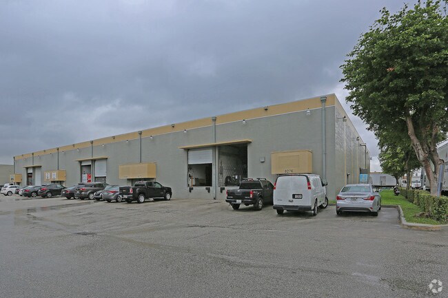
Property Record
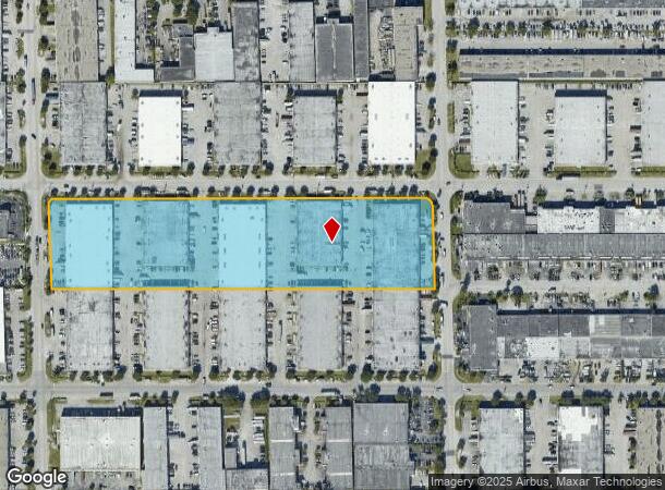
8256 Nw 68Th St, Miami, FL 33166

NEARBY LISTINGS FOR SALE OR LEASE
Property Detail
8256 Nw 68Th St
30-3015-001-0221
Fla Fruit Land Co Sub
Warehouse
15 53 40 8.68 AC FLA FRUIT LAND CO SUB PB 2-17 ALL OF TR 23 LESS W & E35FT FOR R/W & LESS N35FT OF E1/2 & LESS N35FT OF W396FT FOR R/W OR 13268-2538 0487 5 COC 24044-4124 12 2005 5 F/A/U 3030150010221
AH
Miami/Dade
12086C0279L
Florida
2024
8.68 AC
2025
Miami Airport North
009066
South Florida
177,046 SF
Miami-Miami Beach-Kendall, FL
DEMOGRAPHICS near 8256 Nw 68Th St
1 Mile
3 Mile
5 Mile
2024 Total Population
1,080
144,884
396,023
2029 Population
1,122
142,640
385,794
Pop Growth 2024-2029
+ 3.89%
(1.55%)
(2.58%)
Average Age
36
41
42
2024 Total Households
430
49,972
133,210
HH Growth 2024-2029
+ 3.49%
(2.00%)
(2.97%)
Median Household Inc
$61,400
$52,101
$53,186
Avg Household Size
2.50
2.80
2.90
2024 Avg HH Vehicles
2.00
2.00
2.00
Median Home Value
$593,137
$368,606
$336,962
Median Year Built
2010
1985
1981
Nearby Places
Map Layers
Map Styles
 Street
 Aerial
- Restaurants
- Banks
- Shops
- Fitness
- Groceries
PUBLIC TRANSPORTATION
COMMUTER RAIL
Palmetto (Metrorail Green Line - Miami-Dade Transit (Metrorail/Metromover))
DRIVE
WALK
Distance
Palmetto (Metrorail Green Line - Miami-Dade Transit (Metrorail/Metromover))
4 min
1.5 mi
Okeechobee (Metrorail Green Line - Miami-Dade Transit (Metrorail/Metromover))
DRIVE
WALK
Distance
Okeechobee (Metrorail Green Line - Miami-Dade Transit (Metrorail/Metromover))
7 min
3.2 mi
AIRPORT
Miami International
DRIVE
WALK
Distance
Miami International
14 min
5.5 mi
Fort Lauderdale/Hollywood International
DRIVE
WALK
Distance
Fort Lauderdale/Hollywood International
40 min
26.9 mi
Freight Ports
Port of Miami
DRIVE
WALK
Distance
Port of Miami
27 min
15.0 mi
SALE & LEASE HISTORY
LISTING DATE
SALE/LEASE

Mar 18, 2024
For Lease
Nearby Properties
Address
Land Use
TOTAL SIZE
Lot Size
Zoning
Address
Land Use
TOTAL SIZE
Lot Size
Zoning
1,071,874 SF
6.73 AC
4802
Address
Land Use
TOTAL SIZE
Lot Size
Zoning
312,996 SF
157.16 AC
8900
Address
Land Use
TOTAL SIZE
Lot Size
Zoning
851,502 SF
11.73 AC
6119
Address
Land Use
TOTAL SIZE
Lot Size
Zoning
481,242 SF
13.61 AC
6400
Address
Land Use
TOTAL SIZE
Lot Size
Zoning
777,714 SF
7.59 AC
9450
Address
Land Use
TOTAL SIZE
Lot Size
Zoning
666,015 SF
4 AC
6119
Address
Land Use
TOTAL SIZE
Lot Size
Zoning
582,921 SF
4.51 AC
6119
Address
Land Use
TOTAL SIZE
Lot Size
Zoning
929,765 SF
453.69 AC
6119
Address
Land Use
TOTAL SIZE
Lot Size
Zoning
418,532 SF
17.95 AC
7300
Address
Land Use
TOTAL SIZE
Lot Size
Zoning
608,139 SF
5.80 AC
6119
Address
Land Use
TOTAL SIZE
Lot Size
Zoning
612,289 SF
3.38 AC
6119
Address
Land Use
TOTAL SIZE
Lot Size
Zoning
540,427 SF
26.86 AC
3700
Address
Land Use
TOTAL SIZE
Lot Size
Zoning
498,676 SF
25.96 AC
9450
Address
Land Use
TOTAL SIZE
Lot Size
Zoning
1,700 SF
7.24 AC
7100
Address
Land Use
TOTAL SIZE
Lot Size
Zoning
687,804 SF
3.84 AC
9450
Address
Land Use
TOTAL SIZE
Lot Size
Zoning
301,593 SF
16 AC
7100
Address
Land Use
TOTAL SIZE
Lot Size
Zoning
538,715 SF
24.72 AC
7100
Address
Land Use
TOTAL SIZE
Lot Size
Zoning
352,663 SF
0.65 AC
6119
Address
Land Use
TOTAL SIZE
Lot Size
Zoning
359,107 SF
9.58 AC
9450
Address
Land Use
TOTAL SIZE
Lot Size
Zoning
322,084 SF
6.60 AC
7100
Address
Land Use
TOTAL SIZE
Lot Size
Zoning
344,465 SF
5.03 AC
6400
Address
Land Use
TOTAL SIZE
Lot Size
Zoning
468,218 SF
17.06 AC
7100
Address
Land Use
TOTAL SIZE
Lot Size
Zoning
344,101 SF
0.74 AC
6119
Address
Land Use
TOTAL SIZE
Lot Size
Zoning
533,605 SF
10.86 AC
9450
Address
Land Use
TOTAL SIZE
Lot Size
Zoning
687,304 SF
3.03 AC
6119
Address
Land Use
TOTAL SIZE
Lot Size
Zoning
648,867 SF
33.08 AC
7100
Address
Land Use
TOTAL SIZE
Lot Size
Zoning
255,793 SF
17.14 AC
8000
Address
Land Use
TOTAL SIZE
Lot Size
Zoning
527,157 SF
4.15 AC
6119
Address
Land Use
TOTAL SIZE
Lot Size
Zoning
538,739 SF
5.05 AC
7100
Address
Land Use
TOTAL SIZE
Lot Size
Zoning
387,903 SF
4.49 AC
6119
The World's #1 Commercial Real Estate Marketplace
Connect with us
© 2025 CoStar Group
The information above has been obtained from sources believed reliable. While we do not doubt its accuracy we have not verified it and make no guarantee, warranty or representation about it. It is your responsibility to independently confirm its accuracy and completeness. Any projections, opinions, assumptions, or estimates used are for example only and do not represent the current or future performance of the property. The value of this transaction to you depends on tax and other factors which should be evaluated by your tax, financial, and legal advisors. You and your advisors should conduct a careful, independent investigation of the property to determine to your satisfaction the suitability of the property for your needs.