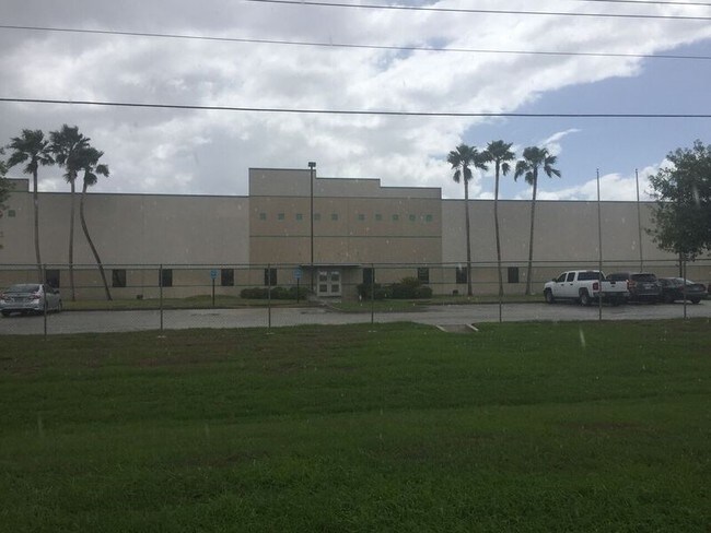
Property Record
826 N Fm 509, Harlingen, TX 78550

NEARBY LISTINGS FOR SALE OR LEASE
Property Detail
826 N Fm 509
Brownsville-Harlingen, TX
Harlingen Industrial Park Subd 4
982084-0010-001000
HARLINGEN INDUSTRIAL PARK NUMBER 4 LOT 1 BLK 1 (CAB 1 SLOT 2039-AB CCMR)
Industrialgeneral
Cameron
X
Texas
48061C0260F
1
2024
16.56 AC
2025
Outlying Cameron County
010802
Brownsville/Harlingen
43,032 SF
DEMOGRAPHICS near 826 N Fm 509
1 Mile
3 Mile
5 Mile
2024 Total Population
21
18,318
72,674
2029 Population
24
18,970
74,344
Pop Growth 2024-2029
+ 14.29%
+ 3.56%
+ 2.30%
Average Age
31
36
37
2024 Total Households
4
6,438
24,812
HH Growth 2024-2029
+ 25.00%
+ 3.37%
+ 2.22%
Median Household Inc
$22,500
$58,395
$46,003
Avg Household Size
2.50
2.70
2.80
2024 Avg HH Vehicles
1.00
2.00
2.00
Median Home Value
$0
$117,240
$95,848
Median Year Built
2010
1987
1983
Nearby Places
Map Layers
Map Styles
 Street
 Aerial
- Restaurants
- Banks
- Shops
- Fitness
- Groceries
PUBLIC TRANSPORTATION
AIRPORT
Valley International
DRIVE
WALK
Distance
Valley International
11 min
5.5 mi
Brownsville/South Padre Island International
DRIVE
WALK
Distance
Brownsville/South Padre Island International
42 min
28.7 mi
Freight Ports
Port of Brownsville
DRIVE
WALK
Distance
Port of Brownsville
35 min
26.4 mi
Nearby Properties
Address
Land Use
TOTAL SIZE
Lot Size
Zoning
Address
Land Use
TOTAL SIZE
Lot Size
Zoning
663,572 SF
60.74 AC
I
Address
Land Use
TOTAL SIZE
Lot Size
Zoning
100,090 SF
15 AC
Address
Land Use
TOTAL SIZE
Lot Size
Zoning
134,518 SF
10.01 AC
Address
Land Use
TOTAL SIZE
Lot Size
Zoning
118,561 SF
6.32 AC
C
Address
Land Use
TOTAL SIZE
Lot Size
Zoning
16,508 SF
347.82 AC
Address
Land Use
TOTAL SIZE
Lot Size
Zoning
20,062 SF
47.54 AC
C
Address
Land Use
TOTAL SIZE
Lot Size
Zoning
230,267 SF
7.85 AC
C
Address
Land Use
TOTAL SIZE
Lot Size
Zoning
180,838 SF
12.56 AC
C
Address
Land Use
TOTAL SIZE
Lot Size
Zoning
176,627 SF
12.45 AC
A-C
Address
Land Use
TOTAL SIZE
Lot Size
Zoning
84,936 SF
12 AC
Address
Land Use
TOTAL SIZE
Lot Size
Zoning
188,102 SF
45.81 AC
C
Address
Land Use
TOTAL SIZE
Lot Size
Zoning
93,459 SF
20 AC
Address
Land Use
TOTAL SIZE
Lot Size
Zoning
7,600 SF
16.94 AC
Address
Land Use
TOTAL SIZE
Lot Size
Zoning
45,408 SF
12 AC
Address
Land Use
TOTAL SIZE
Lot Size
Zoning
73,926 SF
4.39 AC
Address
Land Use
TOTAL SIZE
Lot Size
Zoning
105,000 SF
9.15 AC
C
Address
Land Use
TOTAL SIZE
Lot Size
Zoning
93,613 SF
4.20 AC
C
Address
Land Use
TOTAL SIZE
Lot Size
Zoning
18.61 AC
C
Address
Land Use
TOTAL SIZE
Lot Size
Zoning
92,292 SF
3.93 AC
Address
Land Use
TOTAL SIZE
Lot Size
Zoning
89,873 SF
3.81 AC
Address
Land Use
TOTAL SIZE
Lot Size
Zoning
60,683 SF
5.53 AC
Address
Land Use
TOTAL SIZE
Lot Size
Zoning
88,964 SF
4.38 AC
I
Address
Land Use
TOTAL SIZE
Lot Size
Zoning
84,384 SF
9.90 AC
Address
Land Use
TOTAL SIZE
Lot Size
Zoning
47,480 SF
5.44 AC
A-C
Address
Land Use
TOTAL SIZE
Lot Size
Zoning
68,901 SF
5.49 AC
C
Address
Land Use
TOTAL SIZE
Lot Size
Zoning
80,000 SF
19.63 AC
C
Address
Land Use
TOTAL SIZE
Lot Size
Zoning
36,064 SF
5.51 AC
C
Address
Land Use
TOTAL SIZE
Lot Size
Zoning
36,801 SF
19.24 AC
Address
Land Use
TOTAL SIZE
Lot Size
Zoning
65,375 SF
4.25 AC
C
The World's #1 Commercial Real Estate Marketplace
Connect with us
© 2026 CoStar Group
The information above has been obtained from sources believed reliable. While we do not doubt its accuracy we have not verified it and make no guarantee, warranty or representation about it. It is your responsibility to independently confirm its accuracy and completeness. Any projections, opinions, assumptions, or estimates used are for example only and do not represent the current or future performance of the property. The value of this transaction to you depends on tax and other factors which should be evaluated by your tax, financial, and legal advisors. You and your advisors should conduct a careful, independent investigation of the property to determine to your satisfaction the suitability of the property for your needs.