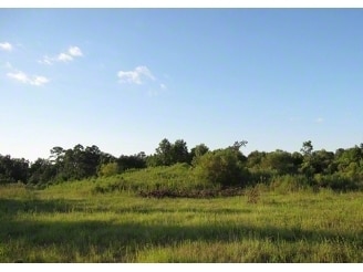
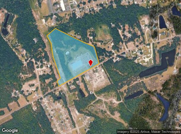
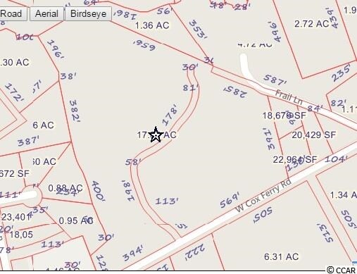
Property Record
826 W Cox Ferry Rd, Conway, SC 29526
NEARBY LISTINGS FOR SALE OR LEASE
Property Detail
826 W Cox Ferry Rd
38200000008
Max R Smith & Derrick M Blanto
Publicschool
COX FERRY ROAD
AE
Horry
45051C0541K
South Carolina
0
18.03 AC
2024
Socastee/Red Hill
060101
Myrtle Beach/Conway
30,172 SF
Myrtle Beach-Conway-North Myrtle Beach, SC-NC
DEMOGRAPHICS near 826 W Cox Ferry Rd
1 Mile
3 Mile
5 Mile
2024 Total Population
3,781
25,007
52,039
2029 Population
4,429
29,726
62,374
Pop Growth 2024-2029
+ 17.14%
+ 18.87%
+ 19.86%
Average Age
28
37
40
2024 Total Households
710
7,816
18,669
HH Growth 2024-2029
+ 19.01%
+ 18.62%
+ 19.02%
Median Household Inc
$54,605
$49,881
$53,182
Avg Household Size
2.40
2.40
2.40
2024 Avg HH Vehicles
2.00
2.00
2.00
Median Home Value
$195,108
$193,446
$202,929
Median Year Built
1978
1992
1994
Nearby Places
Map Layers
Map Styles
 Street
 Aerial
- Restaurants
- Banks
- Shops
- Fitness
- Groceries
PUBLIC TRANSPORTATION
AIRPORT
Myrtle Beach International
DRIVE
WALK
Distance
Myrtle Beach International
23 min
13.4 mi
Freight Ports
Port of Wilmington
DRIVE
WALK
Distance
Port of Wilmington
106 min
84.0 mi
SALE & LEASE HISTORY
LISTING DATE
SALE/LEASE

Sep 24, 2016
For Sale
Oct 11, 2016
For Sale
Oct 11, 2016
For Sale
Nearby Properties
Address
Land Use
TOTAL SIZE
Lot Size
Zoning
Address
Land Use
TOTAL SIZE
Lot Size
Zoning
16,884 SF
54.33 AC
Address
Land Use
TOTAL SIZE
Lot Size
Zoning
381,183 SF
43.41 AC
Address
Land Use
TOTAL SIZE
Lot Size
Zoning
747.28 AC
Address
Land Use
TOTAL SIZE
Lot Size
Zoning
84,572 SF
15.01 AC
Address
Land Use
TOTAL SIZE
Lot Size
Zoning
8,410 SF
20.72 AC
Address
Land Use
TOTAL SIZE
Lot Size
Zoning
57,608 SF
11.54 AC
Address
Land Use
TOTAL SIZE
Lot Size
Zoning
96,796 SF
11.74 AC
Address
Land Use
TOTAL SIZE
Lot Size
Zoning
11,409 SF
15.61 AC
Address
Land Use
TOTAL SIZE
Lot Size
Zoning
108,700 SF
7.97 AC
Address
Land Use
TOTAL SIZE
Lot Size
Zoning
140,206 SF
24.63 AC
Address
Land Use
TOTAL SIZE
Lot Size
Zoning
45,090 SF
7.86 AC
Address
Land Use
TOTAL SIZE
Lot Size
Zoning
133,032 SF
12.56 AC
Address
Land Use
TOTAL SIZE
Lot Size
Zoning
310,546 SF
11.98 AC
Address
Land Use
TOTAL SIZE
Lot Size
Zoning
57.24 AC
Address
Land Use
TOTAL SIZE
Lot Size
Zoning
27.48 AC
Address
Land Use
TOTAL SIZE
Lot Size
Zoning
26,832 SF
5.95 AC
Address
Land Use
TOTAL SIZE
Lot Size
Zoning
13,776 SF
6.79 AC
Address
Land Use
TOTAL SIZE
Lot Size
Zoning
131,858 SF
16.19 AC
Address
Land Use
TOTAL SIZE
Lot Size
Zoning
69,720 SF
10.29 AC
Address
Land Use
TOTAL SIZE
Lot Size
Zoning
18,012 SF
9.33 AC
Address
Land Use
TOTAL SIZE
Lot Size
Zoning
111.44 AC
Address
Land Use
TOTAL SIZE
Lot Size
Zoning
36.77 AC
Address
Land Use
TOTAL SIZE
Lot Size
Zoning
17,570 SF
9.24 AC
Address
Land Use
TOTAL SIZE
Lot Size
Zoning
28.93 AC
Address
Land Use
TOTAL SIZE
Lot Size
Zoning
30,192 SF
5.09 AC
Address
Land Use
TOTAL SIZE
Lot Size
Zoning
91,897 SF
25.13 AC
Address
Land Use
TOTAL SIZE
Lot Size
Zoning
490 SF
92.93 AC
Address
Land Use
TOTAL SIZE
Lot Size
Zoning
6,833 SF
384.95 AC
The World's #1 Commercial Real Estate Marketplace
Connect with us
© 2025 CoStar Group
The information above has been obtained from sources believed reliable. While we do not doubt its accuracy we have not verified it and make no guarantee, warranty or representation about it. It is your responsibility to independently confirm its accuracy and completeness. Any projections, opinions, assumptions, or estimates used are for example only and do not represent the current or future performance of the property. The value of this transaction to you depends on tax and other factors which should be evaluated by your tax, financial, and legal advisors. You and your advisors should conduct a careful, independent investigation of the property to determine to your satisfaction the suitability of the property for your needs.