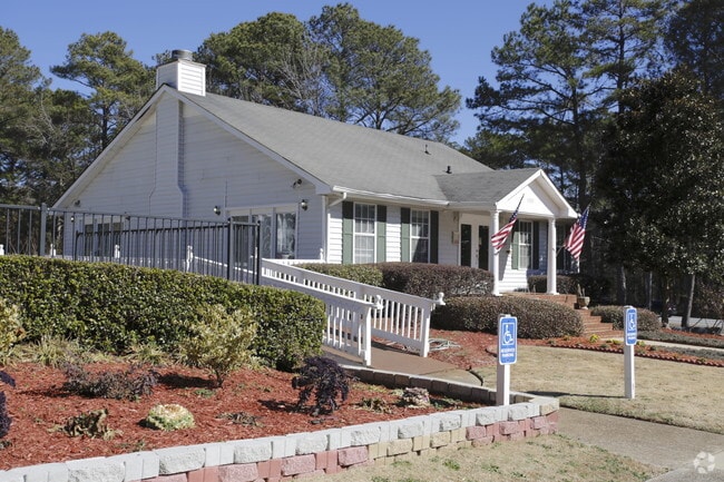
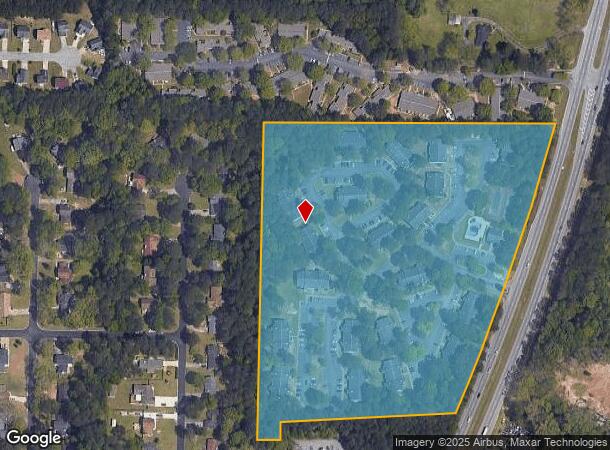
Property Record
8265 Highway 85, Riverdale, GA 30274
NEARBY LISTINGS FOR SALE OR LEASE
-
-
View all Riverdale listings for sale on LoopNet.com
Property Detail
8265 Highway 85
13-00233-233-021
Chase Rdg Partments
Gardenaptcourtapt5plusunits
Clayton
X
Georgia
13063C0068F
233
2025
17.67 AC
2025
Clayton County
040523
Atlanta
176 SF
Atlanta-Sandy Springs-Roswell, GA
DEMOGRAPHICS near 8265 Highway 85
1 Mile
3 Mile
5 Mile
2024 Total Population
11,096
63,119
158,616
2029 Population
11,038
63,035
159,638
Pop Growth 2024-2029
(0.52%)
(0.13%)
+ 0.64%
Average Age
36
37
37
2024 Total Households
4,187
22,346
57,494
HH Growth 2024-2029
(0.55%)
(0.15%)
+ 0.60%
Median Household Inc
$51,777
$54,217
$52,981
Avg Household Size
2.60
2.80
2.70
2024 Avg HH Vehicles
2.00
2.00
2.00
Median Home Value
$172,056
$176,916
$183,775
Median Year Built
1988
1986
1985
Nearby Places
Map Layers
Map Styles
 Street
 Aerial
- Restaurants
- Banks
- Shops
- Fitness
- Groceries
PUBLIC TRANSPORTATION
AIRPORT
Hartsfield - Jackson Atlanta International
DRIVE
WALK
Distance
Hartsfield - Jackson Atlanta International
19 min
10.2 mi
Freight Ports
Georgia Ports - Savannah
DRIVE
WALK
Distance
Georgia Ports - Savannah
272 min
240.9 mi
Nearby Properties
Address
Land Use
TOTAL SIZE
Lot Size
Zoning
Address
Land Use
TOTAL SIZE
Lot Size
Zoning
40,472 SF
116.70 AC
HI
Address
Land Use
TOTAL SIZE
Lot Size
Zoning
324 SF
49.49 AC
RM
Address
Land Use
TOTAL SIZE
Lot Size
Zoning
123,000 SF
48 AC
RS110
Address
Land Use
TOTAL SIZE
Lot Size
Zoning
424 SF
54.79 AC
RM
Address
Land Use
TOTAL SIZE
Lot Size
Zoning
270 SF
28.02 AC
RM
Address
Land Use
TOTAL SIZE
Lot Size
Zoning
278 SF
18.53 AC
PUD
Address
Land Use
TOTAL SIZE
Lot Size
Zoning
316 SF
34.30 AC
RG75
Address
Land Use
TOTAL SIZE
Lot Size
Zoning
224 SF
25 AC
C
Address
Land Use
TOTAL SIZE
Lot Size
Zoning
256 SF
25 AC
PUD
Address
Land Use
TOTAL SIZE
Lot Size
Zoning
220 SF
26.84 AC
RM
Address
Land Use
TOTAL SIZE
Lot Size
Zoning
57.05 AC
GB
Address
Land Use
TOTAL SIZE
Lot Size
Zoning
160 SF
19.95 AC
RM
Address
Land Use
TOTAL SIZE
Lot Size
Zoning
203,067 SF
18 AC
C
Address
Land Use
TOTAL SIZE
Lot Size
Zoning
147,540 SF
47.10 AC
C RP
Address
Land Use
TOTAL SIZE
Lot Size
Zoning
108,738 SF
28.31 AC
C
Address
Land Use
TOTAL SIZE
Lot Size
Zoning
200 SF
13.12 AC
RM
Address
Land Use
TOTAL SIZE
Lot Size
Zoning
138,822 SF
15.49 AC
C
Address
Land Use
TOTAL SIZE
Lot Size
Zoning
214 SF
20.97 AC
C
Address
Land Use
TOTAL SIZE
Lot Size
Zoning
141,792 SF
18.50 AC
RS110
Address
Land Use
TOTAL SIZE
Lot Size
Zoning
86,781 SF
16 AC
RS110
Address
Land Use
TOTAL SIZE
Lot Size
Zoning
192,012 SF
16.93 AC
C
Address
Land Use
TOTAL SIZE
Lot Size
Zoning
105,795 SF
13.55 AC
C
Address
Land Use
TOTAL SIZE
Lot Size
Zoning
78,669 SF
16.60 AC
C
Address
Land Use
TOTAL SIZE
Lot Size
Zoning
39,498 SF
28.80 AC
GB
Address
Land Use
TOTAL SIZE
Lot Size
Zoning
138,852 SF
6.72 AC
C CH
Address
Land Use
TOTAL SIZE
Lot Size
Zoning
150 SF
14.50 AC
RM
Address
Land Use
TOTAL SIZE
Lot Size
Zoning
84,682 SF
9.32 AC
C
Address
Land Use
TOTAL SIZE
Lot Size
Zoning
103,897 SF
14.92 AC
C
Address
Land Use
TOTAL SIZE
Lot Size
Zoning
106 SF
10.19 AC
RM
The World's #1 Commercial Real Estate Marketplace
Connect with us
© 2026 CoStar Group
The information above has been obtained from sources believed reliable. While we do not doubt its accuracy we have not verified it and make no guarantee, warranty or representation about it. It is your responsibility to independently confirm its accuracy and completeness. Any projections, opinions, assumptions, or estimates used are for example only and do not represent the current or future performance of the property. The value of this transaction to you depends on tax and other factors which should be evaluated by your tax, financial, and legal advisors. You and your advisors should conduct a careful, independent investigation of the property to determine to your satisfaction the suitability of the property for your needs.