Property Record
8265 Richardson Rd, Commerce Township, MI 48390
NEARBY LISTINGS FOR SALE OR LEASE
Property Detail
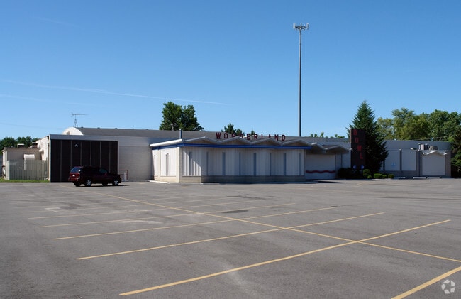
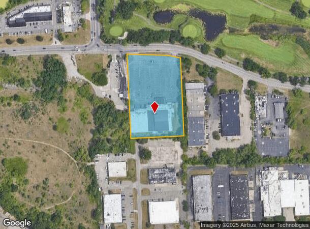
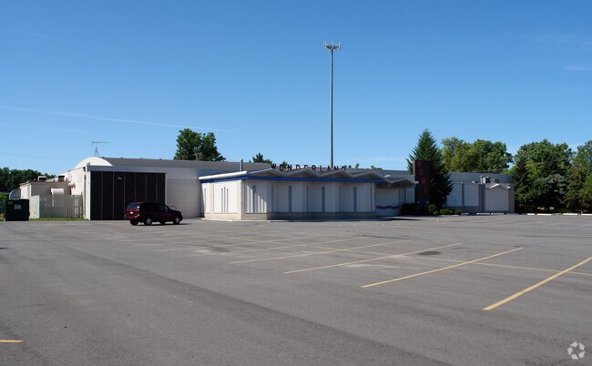
8265 Richardson Rd
17-13-400-026
Se Crnr Sec 13
Bowlingalley
T2N, R8E, SEC 13 PART OF SE 1/4 BEG AT PT DIST N 00-36-00 E 1326.80 FT & N 89-55-30 W 1454.25 FT & N 00-22-20 E 815.53 FT FROM SE SEC COR, TH N 00-22-20 E 476.95 FT, TH S 88-10-00 E 235.34 FT, TH S 67-32-00 E 69.86 FT, TH S 00-22-20 W 443.22 FT, TH N
X
Oakland
26125C0479F
Michigan
2024
3.24 AC
2024
Central I-96 Corridor
134400
Detroit
36,297 SF
Detroit-Warren-Dearborn, MI
DEMOGRAPHICS near 8265 Richardson Rd
1 Mile
3 Mile
5 Mile
2024 Total Population
4,157
49,478
150,196
2029 Population
4,116
49,095
148,932
Pop Growth 2024-2029
(0.99%)
(0.77%)
(0.84%)
Average Age
41
43
44
2024 Total Households
1,505
19,350
61,012
HH Growth 2024-2029
(1.00%)
(0.76%)
(0.78%)
Median Household Inc
$114,351
$103,068
$96,404
Avg Household Size
2.70
2.50
2.40
2024 Avg HH Vehicles
2.00
2.00
2.00
Median Home Value
$366,330
$339,539
$333,990
Median Year Built
1976
1981
1985
Nearby Places
Map Layers
Map Styles
 Street
 Aerial
- Restaurants
- Banks
- Shops
- Fitness
- Groceries
PUBLIC TRANSPORTATION
AIRPORT
Detroit Metro Wayne County
DRIVE
WALK
Distance
Detroit Metro Wayne County
45 min
33.6 mi
Bishop International
DRIVE
WALK
Distance
Bishop International
61 min
38.3 mi
Windsor International
DRIVE
WALK
Distance
Windsor International
68 min
43.8 mi
Nearby Properties
Address
Land Use
TOTAL SIZE
Lot Size
Zoning
Address
Land Use
TOTAL SIZE
Lot Size
Zoning
352,614 SF
53.31 AC
BI
Address
Land Use
TOTAL SIZE
Lot Size
Zoning
614,079 SF
57.44 AC
Address
Land Use
TOTAL SIZE
Lot Size
Zoning
659,897 SF
53.96 AC
AI
Address
Land Use
TOTAL SIZE
Lot Size
Zoning
400,505 SF
26.50 AC
Address
Land Use
TOTAL SIZE
Lot Size
Zoning
427,062 SF
31.20 AC
AI
Address
Land Use
TOTAL SIZE
Lot Size
Zoning
411,118 SF
43.95 AC
AI
Address
Land Use
TOTAL SIZE
Lot Size
Zoning
204,652 SF
9.62 AC
BI
Address
Land Use
TOTAL SIZE
Lot Size
Zoning
367,354 SF
62.73 AC
AI
Address
Land Use
TOTAL SIZE
Lot Size
Zoning
188,643 SF
12.81 AC
IV
Address
Land Use
TOTAL SIZE
Lot Size
Zoning
269,975 SF
23.88 AC
AI
Address
Land Use
TOTAL SIZE
Lot Size
Zoning
115,400 SF
9.38 AC
BI
Address
Land Use
TOTAL SIZE
Lot Size
Zoning
260,330 SF
21.04 AC
AI
Address
Land Use
TOTAL SIZE
Lot Size
Zoning
244,500 SF
7.80 AC
AI
Address
Land Use
TOTAL SIZE
Lot Size
Zoning
222,664 SF
21.10 AC
BI
Address
Land Use
TOTAL SIZE
Lot Size
Zoning
196,222 SF
Address
Land Use
TOTAL SIZE
Lot Size
Zoning
118,592 SF
Address
Land Use
TOTAL SIZE
Lot Size
Zoning
169,638 SF
16.39 AC
Address
Land Use
TOTAL SIZE
Lot Size
Zoning
206,191 SF
23.73 AC
Address
Land Use
TOTAL SIZE
Lot Size
Zoning
227,399 SF
14.73 AC
II
Address
Land Use
TOTAL SIZE
Lot Size
Zoning
236,315 SF
35.86 AC
AI
Address
Land Use
TOTAL SIZE
Lot Size
Zoning
15,332 SF
10 AC
RI
Address
Land Use
TOTAL SIZE
Lot Size
Zoning
206,191 SF
24.88 AC
BI
Address
Land Use
TOTAL SIZE
Lot Size
Zoning
128,868 SF
13.25 AC
BI
Address
Land Use
TOTAL SIZE
Lot Size
Zoning
135,714 SF
14.72 AC
BI
Address
Land Use
TOTAL SIZE
Lot Size
Zoning
140,310 SF
Address
Land Use
TOTAL SIZE
Lot Size
Zoning
97,080 SF
12.53 AC
BI
Address
Land Use
TOTAL SIZE
Lot Size
Zoning
140,310 SF
17.16 AC
BI
Address
Land Use
TOTAL SIZE
Lot Size
Zoning
100,000 SF
13.21 AC
Address
Land Use
TOTAL SIZE
Lot Size
Zoning
114,959 SF
11.40 AC
BI
Address
Land Use
TOTAL SIZE
Lot Size
Zoning
110,300 SF
2.26 AC
The World's #1 Commercial Real Estate Marketplace
Connect with us
© 2025 CoStar Group
The information above has been obtained from sources believed reliable. While we do not doubt its accuracy we have not verified it and make no guarantee, warranty or representation about it. It is your responsibility to independently confirm its accuracy and completeness. Any projections, opinions, assumptions, or estimates used are for example only and do not represent the current or future performance of the property. The value of this transaction to you depends on tax and other factors which should be evaluated by your tax, financial, and legal advisors. You and your advisors should conduct a careful, independent investigation of the property to determine to your satisfaction the suitability of the property for your needs.