Property Record
827 Railroad St, Port Orange, FL 32129
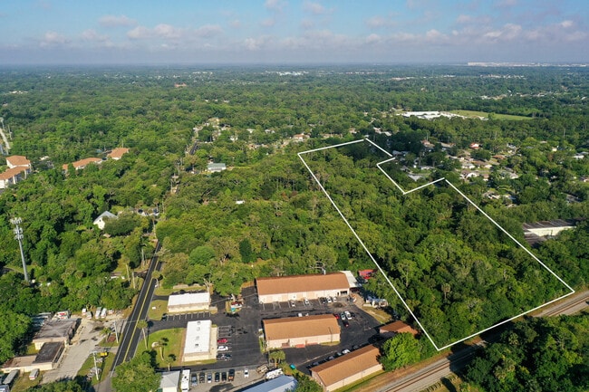
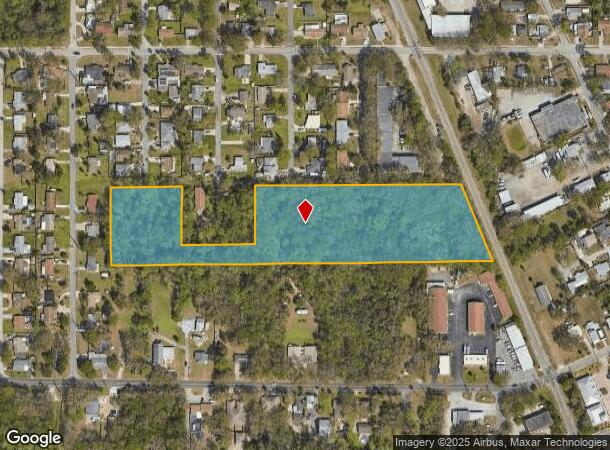
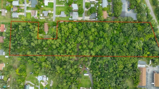
This Property Is For Sale
NEARBY LISTINGS FOR SALE OR LEASE
Property Detail
827 Railroad St
Deltona-Daytona Beach-Ormond Beach, FL
Portona 1
6304-00-00-0010
4-16-33 N 278.8 FT OF S 1/4 OF GOV LOT 1 EXC E 250 FT OF W 500 FT OF N 200 FT PER UNREC D/C
Sfr
Volusia
X
Florida
12127C0388J
1
2025
7.64 AC
2026
South Daytona Beach
082503
Deltona/Daytona Beach
1,663 SF
DEMOGRAPHICS near 827 Railroad St
1 mile
3 mile
5 mile
2024 Total Population
7,413
67,980
120,285
2029 Population
8,198
75,884
133,889
Pop Growth 2024-2029
+ 10.59%
+ 11.63%
+ 11.31%
Average Age
44
48
46
2024 Total Households
3,297
32,247
54,539
HH Growth 2024-2029
+ 10.74%
+ 11.98%
+ 11.81%
Median Household Inc
$42,760
$50,358
$52,585
Avg Household Size
2.20
2.10
2.10
2024 Avg HH Vehicles
2.00
2.00
2.00
Median Home Value
$193,711
$211,907
$236,576
Median Year Built
1980
1982
1983
Nearby Places
Map Layers
Map Styles
 Street
 Aerial
Transit
 Traffic
 Biking
Places
Listings with unknown addresses are not visible on the map
- Restaurants
- Banks
- Shops
- Fitness
- Groceries
PUBLIC TRANSPORTATION
AIRPORT
Daytona Beach International
Drive
Walk
Distance
Daytona Beach International
14 min
6.8 mi
Orlando Sanford International
Drive
Walk
Distance
Orlando Sanford International
57 min
39.4 mi
Freight Ports
Port Canaveral
Drive
Walk
Distance
Port Canaveral
81 min
68.0 mi
Nearby Properties
Address
Land Use
TOTAL SIZE
Lot Size
Zoning
Address
Land Use
TOTAL SIZE
Lot Size
Zoning
490,775 SF
34.26 AC
01MH1
Address
Land Use
TOTAL SIZE
Lot Size
Zoning
396,385 SF
10 AC
01A2
Address
Land Use
TOTAL SIZE
Lot Size
Zoning
448,867 SF
5.54 AC
Address
Land Use
TOTAL SIZE
Lot Size
Zoning
13,965 SF
0.70 AC
MH1
Address
Land Use
TOTAL SIZE
Lot Size
Zoning
325,744 SF
12.23 AC
Address
Land Use
TOTAL SIZE
Lot Size
Zoning
330,883 SF
19.59 AC
Address
Land Use
TOTAL SIZE
Lot Size
Zoning
269,133 SF
6.33 AC
Address
Land Use
TOTAL SIZE
Lot Size
Zoning
300,516 SF
70 AC
A2
Address
Land Use
TOTAL SIZE
Lot Size
Zoning
379,591 SF
21.62 AC
MH1
Address
Land Use
TOTAL SIZE
Lot Size
Zoning
306,467 SF
20.76 AC
Address
Land Use
TOTAL SIZE
Lot Size
Zoning
10,360 SF
1.56 AC
Address
Land Use
TOTAL SIZE
Lot Size
Zoning
5,774 SF
0.94 AC
B4
Address
Land Use
TOTAL SIZE
Lot Size
Zoning
150,197 SF
16.07 AC
Address
Land Use
TOTAL SIZE
Lot Size
Zoning
94,338 SF
7.39 AC
Address
Land Use
TOTAL SIZE
Lot Size
Zoning
184,242 SF
14.43 AC
Address
Land Use
TOTAL SIZE
Lot Size
Zoning
9,952 SF
9.30 AC
16RMH
Address
Land Use
TOTAL SIZE
Lot Size
Zoning
201,947 SF
0.23 AC
Address
Land Use
TOTAL SIZE
Lot Size
Zoning
269,160 SF
72.17 AC
16A
Address
Land Use
TOTAL SIZE
Lot Size
Zoning
156,994 SF
47.82 AC
16A
Address
Land Use
TOTAL SIZE
Lot Size
Zoning
155,590 SF
11.08 AC
16R3H
Address
Land Use
TOTAL SIZE
Lot Size
Zoning
8,355 SF
1 AC
MH1
Address
Land Use
TOTAL SIZE
Lot Size
Zoning
9,061 SF
0.23 AC
16RMH
Address
Land Use
TOTAL SIZE
Lot Size
Zoning
148,848 SF
9.99 AC
16R3H
Address
Land Use
TOTAL SIZE
Lot Size
Zoning
3,886 SF
3.99 AC
16RMH
Address
Land Use
TOTAL SIZE
Lot Size
Zoning
Address
Land Use
TOTAL SIZE
Lot Size
Zoning
9,833 SF
52.38 AC
16RMH
Address
Land Use
TOTAL SIZE
Lot Size
Zoning
131,376 SF
1.88 AC
03T
Address
Land Use
TOTAL SIZE
Lot Size
Zoning
154,753 SF
14.66 AC
Address
Land Use
TOTAL SIZE
Lot Size
Zoning
4,166 SF
51.05 AC
Address
Land Use
TOTAL SIZE
Lot Size
Zoning
157,147 SF
47.79 AC
16A
The World's #1 Commercial Real Estate Marketplace
Connect with us
© 2026 CoStar Group
The information above has been obtained from sources believed reliable. While we do not doubt its accuracy we have not verified it and make no guarantee, warranty or representation about it. It is your responsibility to independently confirm its accuracy and completeness. Any projections, opinions, assumptions, or estimates used are for example only and do not represent the current or future performance of the property. The value of this transaction to you depends on tax and other factors which should be evaluated by your tax, financial, and legal advisors. You and your advisors should conduct a careful, independent investigation of the property to determine to your satisfaction the suitability of the property for your needs.