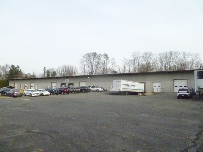
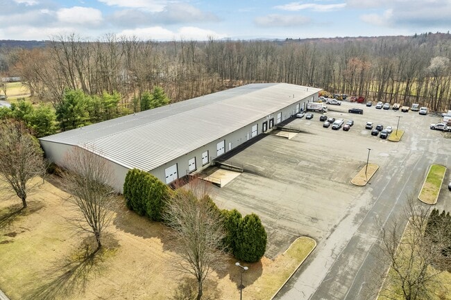
Property Record
827 State Route 52, Walden, NY 12586

Current Lease Availabilities
Property Detail
827 State Route 52
334289-014-000-0001-082.200-0000
U/C PARTIAL ASSESSMENT
Warehouse
Orange
B4
New York
A Areas with a 1% annual chance of flooding and a 26% chance of flooding over the life of a 30-year mortgage.
82.20
2024
5.90 AC
2025
Orange County
010602
Northern New Jersey
43,200 SF
Kiryas Joel-Poughkeepsie-Newburgh, NY
NEARBY LISTINGS FOR SALE OR LEASE
DEMOGRAPHICS near 827 State Route 52
1 mile
3 mile
5 mile
2025 Total Population
1,130
15,985
37,879
2030 Population
1,175
16,316
38,444
Pop Growth 2025-2030
+ 3.98%
+ 2.07%
+ 1.49%
Average Age
42
40
41
2025 Total Households
401
5,659
13,428
HH Growth 2025-2030
+ 4.24%
+ 2.16%
+ 1.56%
Median Household Inc
$88,679
$98,863
$100,994
Avg Household Size
2.70
2.70
2.70
2025 Avg HH Vehicles
2.00
2.00
2.00
Median Home Value
$354,504
$360,649
$367,559
Median Year Built
1970
1969
1976
Nearby Places
Map Layers
Map Styles
 Street
 Aerial
Layers
 Traffic
 Biking
Places
Listings with unknown addresses are not visible on the map
- Restaurants
- Banks
- Shops
- Fitness
- Groceries
PUBLIC TRANSPORTATION
AIRPORT
New York Stewart International
Drive
Walk
Distance
New York Stewart International
14 min
7.2 mi
Freight Ports
Port Newark Container Terminal
Drive
Walk
Distance
Port Newark Container Terminal
98 min
73.2 mi
Nearby Properties
Address
Land Use
TOTAL SIZE
Lot Size
Zoning
Address
Land Use
TOTAL SIZE
Lot Size
Zoning
1,015,632 SF
187.79 AC
I1
Address
Land Use
TOTAL SIZE
Lot Size
Zoning
109,108 SF
15.60 AC
B2
Address
Land Use
TOTAL SIZE
Lot Size
Zoning
34,963 SF
15.10 AC
I1
Address
Land Use
TOTAL SIZE
Lot Size
Zoning
101,595 SF
70.20 AC
RA-.5
Address
Land Use
TOTAL SIZE
Lot Size
Zoning
72,852 SF
2.20 AC
Address
Land Use
TOTAL SIZE
Lot Size
Zoning
110,484 SF
62.90 AC
RA2
Address
Land Use
TOTAL SIZE
Lot Size
Zoning
76,227 SF
5.80 AC
I3
Address
Land Use
TOTAL SIZE
Lot Size
Zoning
Address
Land Use
TOTAL SIZE
Lot Size
Zoning
64,191 SF
10 AC
06
Address
Land Use
TOTAL SIZE
Lot Size
Zoning
Address
Land Use
TOTAL SIZE
Lot Size
Zoning
28,443 SF
34.70 AC
04OP
Address
Land Use
TOTAL SIZE
Lot Size
Zoning
28,443 SF
36.50 AC
04OP
Address
Land Use
TOTAL SIZE
Lot Size
Zoning
149,051 SF
14.10 AC
I1
Address
Land Use
TOTAL SIZE
Lot Size
Zoning
81,563 SF
5.70 AC
B4
Address
Land Use
TOTAL SIZE
Lot Size
Zoning
18,386 SF
54.70 AC
RA-.5
Address
Land Use
TOTAL SIZE
Lot Size
Zoning
74,046 SF
53.80 AC
RA2
Address
Land Use
TOTAL SIZE
Lot Size
Zoning
60.60 AC
06
Address
Land Use
TOTAL SIZE
Lot Size
Zoning
195,821 SF
27.50 AC
I1
Address
Land Use
TOTAL SIZE
Lot Size
Zoning
111,517 SF
6.11 AC
R3
Address
Land Use
TOTAL SIZE
Lot Size
Zoning
Address
Land Use
TOTAL SIZE
Lot Size
Zoning
69,636 SF
7.20 AC
Address
Land Use
TOTAL SIZE
Lot Size
Zoning
82,465 SF
14.40 AC
I1
Address
Land Use
TOTAL SIZE
Lot Size
Zoning
3,442 SF
50.60 AC
RA5
Address
Land Use
TOTAL SIZE
Lot Size
Zoning
26,988 SF
53 AC
RA2
Address
Land Use
TOTAL SIZE
Lot Size
Zoning
2.10 AC
R5
Address
Land Use
TOTAL SIZE
Lot Size
Zoning
42,728 SF
13.10 AC
B4
Address
Land Use
TOTAL SIZE
Lot Size
Zoning
78,179 SF
30.50 AC
I1
Address
Land Use
TOTAL SIZE
Lot Size
Zoning
52,267 SF
4.60 AC
RM2
Address
Land Use
TOTAL SIZE
Lot Size
Zoning
35.80 AC
I1
Address
Land Use
TOTAL SIZE
Lot Size
Zoning
34.20 AC
The World's #1 Commercial Real Estate Marketplace
Connect with us
© 2026 CoStar Group
The information above has been obtained from sources believed reliable. While we do not doubt its accuracy we have not verified it and make no guarantee, warranty or representation about it. It is your responsibility to independently confirm its accuracy and completeness. Any projections, opinions, assumptions, or estimates used are for example only and do not represent the current or future performance of the property. The value of this transaction to you depends on tax and other factors which should be evaluated by your tax, financial, and legal advisors. You and your advisors should conduct a careful, independent investigation of the property to determine to your satisfaction the suitability of the property for your needs.