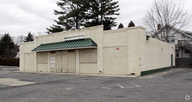
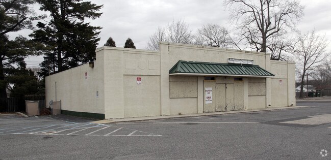
Property Record
827 White Horse Pike, Egg Harbor City, NJ 08215

NEARBY LISTINGS FOR SALE OR LEASE
Property Detail
827 White Horse Pike
07-00433-0000-00012
Atlantic
Storebuilding
New Jersey
ARE
12
34001C0144F
0.34 AC
2024
Atlantic City/Hammonton
2025
Philadelphia
010600
Atlantic City-Hammonton, NJ
3,250 SF
DEMOGRAPHICS near 827 White Horse Pike
1 Mile
3 Mile
5 Mile
2024 Total Population
4,293
7,481
16,858
2029 Population
4,192
7,314
16,555
Pop Growth 2024-2029
(2.35%)
(2.23%)
(1.80%)
Average Age
40
41
41
2024 Total Households
1,667
2,879
6,540
HH Growth 2024-2029
(3.00%)
(2.88%)
(2.32%)
Median Household Inc
$61,510
$66,390
$73,140
Avg Household Size
2.50
2.50
2.50
2024 Avg HH Vehicles
1.00
2.00
2.00
Median Home Value
$178,620
$220,230
$239,730
Median Year Built
1958
1964
1979
Nearby Places
Map Layers
Map Styles
 Street
 Aerial
- Restaurants
- Banks
- Shops
- Fitness
- Groceries
PUBLIC TRANSPORTATION
COMMUTER RAIL
Egg Harbor City (Atlantic City Line - NJ Transit Commuter Rail (NJ Transit))
DRIVE
WALK
Distance
Egg Harbor City (Atlantic City Line - NJ Transit Commuter Rail (NJ Transit))
0 min
5 min
0.3 mi
AIRPORT
Atlantic City International
DRIVE
WALK
Distance
Atlantic City International
31 min
9.3 mi
Freight Ports
Broadway Terminal - Pier 5
DRIVE
WALK
Distance
Broadway Terminal - Pier 5
51 min
39.9 mi
SALE & LEASE HISTORY
LISTING DATE
SALE/LEASE

Sep 23, 2016
For Sale
Nearby Properties
Address
Land Use
TOTAL SIZE
Lot Size
Zoning
Address
Land Use
TOTAL SIZE
Lot Size
Zoning
66.23 AC
3.2C
Address
Land Use
TOTAL SIZE
Lot Size
Zoning
68,744 SF
5.03 AC
R-11
Address
Land Use
TOTAL SIZE
Lot Size
Zoning
94,984 SF
2.07 AC
R-9
Address
Land Use
TOTAL SIZE
Lot Size
Zoning
Address
Land Use
TOTAL SIZE
Lot Size
Zoning
2.27 AC
R-9
Address
Land Use
TOTAL SIZE
Lot Size
Zoning
70.67 AC
RD-5
Address
Land Use
TOTAL SIZE
Lot Size
Zoning
21,056 SF
5.23 AC
IND
Address
Land Use
TOTAL SIZE
Lot Size
Zoning
4,652 SF
14.80 AC
HC-2
Address
Land Use
TOTAL SIZE
Lot Size
Zoning
12,673 SF
2.58 AC
R-9
Address
Land Use
TOTAL SIZE
Lot Size
Zoning
14,546 SF
0.48 AC
R-C
Address
Land Use
TOTAL SIZE
Lot Size
Zoning
15,974 SF
2.87 AC
H-C
Address
Land Use
TOTAL SIZE
Lot Size
Zoning
31.90 AC
TI
Address
Land Use
TOTAL SIZE
Lot Size
Zoning
6,256 SF
4.55 AC
R-22
Address
Land Use
TOTAL SIZE
Lot Size
Zoning
4.13 AC
CRR
Address
Land Use
TOTAL SIZE
Lot Size
Zoning
9,984 SF
0.52 AC
R-6
Address
Land Use
TOTAL SIZE
Lot Size
Zoning
23,500 SF
2.27 AC
H-C
Address
Land Use
TOTAL SIZE
Lot Size
Zoning
2.15 AC
H-C
Address
Land Use
TOTAL SIZE
Lot Size
Zoning
9,972 SF
0.69 AC
R-6
Address
Land Use
TOTAL SIZE
Lot Size
Zoning
8,720 SF
2.76 AC
R-9
Address
Land Use
TOTAL SIZE
Lot Size
Zoning
10,674 SF
0.55 AC
R-9
Address
Land Use
TOTAL SIZE
Lot Size
Zoning
8,056 SF
1.12 AC
R-9
Address
Land Use
TOTAL SIZE
Lot Size
Zoning
10,044 SF
0.28 AC
R-6
Address
Land Use
TOTAL SIZE
Lot Size
Zoning
8,550 SF
0.34 AC
R-C
Address
Land Use
TOTAL SIZE
Lot Size
Zoning
17 AC
AG
Address
Land Use
TOTAL SIZE
Lot Size
Zoning
23.70 AC
PVPT
Address
Land Use
TOTAL SIZE
Lot Size
Zoning
4,935 SF
1.38 AC
R-9
Address
Land Use
TOTAL SIZE
Lot Size
Zoning
20 AC
RD
Address
Land Use
TOTAL SIZE
Lot Size
Zoning
1,000,000 SF
4 AC
HC-2
Address
Land Use
TOTAL SIZE
Lot Size
Zoning
47,696 SF
4.87 AC
IND
Address
Land Use
TOTAL SIZE
Lot Size
Zoning
12,566 SF
0.96 AC
H-C
The World's #1 Commercial Real Estate Marketplace
Connect with us
© 2025 CoStar Group
The information above has been obtained from sources believed reliable. While we do not doubt its accuracy we have not verified it and make no guarantee, warranty or representation about it. It is your responsibility to independently confirm its accuracy and completeness. Any projections, opinions, assumptions, or estimates used are for example only and do not represent the current or future performance of the property. The value of this transaction to you depends on tax and other factors which should be evaluated by your tax, financial, and legal advisors. You and your advisors should conduct a careful, independent investigation of the property to determine to your satisfaction the suitability of the property for your needs.