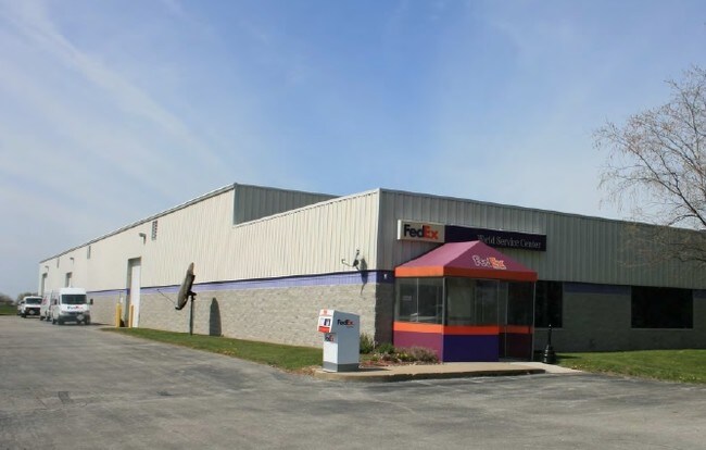
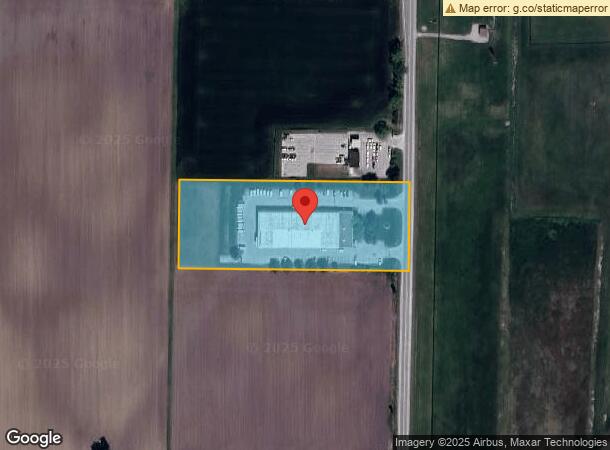
Property Record
8273 Garfield Rd, Freeland, MI 48623

NEARBY LISTINGS FOR SALE OR LEASE
-
-
View all Freeland listings for sale on LoopNet.com
Property Detail
8273 Garfield Rd
29133154002004
N 250 FT OF S 1405 FT OF E 620 FT OF W 1/2 OF SE 1/4 3.56 ACRES SEC 15 T13N R3E
Commercialnec
Saginaw
X
Michigan
26145C0040E
3.56 AC
2025
Midland/Flint
2025
Other Market Areas
010101
Saginaw, MI
27,000 SF
DEMOGRAPHICS near 8273 Garfield Rd
1 Mile
3 Mile
5 Mile
2024 Total Population
2,358
9,039
18,276
2029 Population
2,322
8,870
17,902
Pop Growth 2024-2029
(1.53%)
(1.87%)
(2.05%)
Average Age
40
40
40
2024 Total Households
672
2,719
6,000
HH Growth 2024-2029
(1.79%)
(2.17%)
(2.32%)
Median Household Inc
$80,876
$83,235
$82,662
Avg Household Size
2.60
2.60
2.50
2024 Avg HH Vehicles
2.00
2.00
2.00
Median Home Value
$189,826
$204,453
$200,261
Median Year Built
1977
1983
1983
Nearby Places
Map Layers
Map Styles
 Street
 Aerial
- Restaurants
- Banks
- Shops
- Fitness
- Groceries
PUBLIC TRANSPORTATION
AIRPORT
MBS International
DRIVE
WALK
Distance
MBS International
5 min
1.8 mi
SALE & LEASE HISTORY
LISTING DATE
SALE/LEASE

Aug 15, 2019
For Sale
Nearby Properties
Address
Land Use
TOTAL SIZE
Lot Size
Zoning
Address
Land Use
TOTAL SIZE
Lot Size
Zoning
249.60 AC
Address
Land Use
TOTAL SIZE
Lot Size
Zoning
38.90 AC
Address
Land Use
TOTAL SIZE
Lot Size
Zoning
Address
Land Use
TOTAL SIZE
Lot Size
Zoning
56,576 SF
6.41 AC
A1-AGRI
Address
Land Use
TOTAL SIZE
Lot Size
Zoning
4,824 SF
13.81 AC
R-2
Address
Land Use
TOTAL SIZE
Lot Size
Zoning
42,202 SF
640 AC
A1-AGRI
Address
Land Use
TOTAL SIZE
Lot Size
Zoning
6,580 SF
38.90 AC
R-3
Address
Land Use
TOTAL SIZE
Lot Size
Zoning
30,221 SF
4.05 AC
A1-AGRI
Address
Land Use
TOTAL SIZE
Lot Size
Zoning
21,006 SF
1.71 AC
A1-AGRI
Address
Land Use
TOTAL SIZE
Lot Size
Zoning
107,214 SF
5 AC
A1-AGRI
Address
Land Use
TOTAL SIZE
Lot Size
Zoning
47,000 SF
13.26 AC
A1-AGRI
Address
Land Use
TOTAL SIZE
Lot Size
Zoning
39,768 SF
3.01 AC
A1-AGRI
Address
Land Use
TOTAL SIZE
Lot Size
Zoning
39,392 SF
6.29 AC
A1-AGRI
Address
Land Use
TOTAL SIZE
Lot Size
Zoning
412.50 AC
Address
Land Use
TOTAL SIZE
Lot Size
Zoning
20,756 SF
A1-AGRI
Address
Land Use
TOTAL SIZE
Lot Size
Zoning
37,612 SF
3.64 AC
A1-AGRI
Address
Land Use
TOTAL SIZE
Lot Size
Zoning
30,646 SF
4.15 AC
C-1,C-2,C-
Address
Land Use
TOTAL SIZE
Lot Size
Zoning
28,234 SF
3.17 AC
C-1,C-2,C-
Address
Land Use
TOTAL SIZE
Lot Size
Zoning
33,280 SF
640 AC
A1-AGRI
Address
Land Use
TOTAL SIZE
Lot Size
Zoning
13,966 SF
9.98 AC
A1-AGRI
Address
Land Use
TOTAL SIZE
Lot Size
Zoning
9,356 SF
1.69 AC
A1-AGRI
Address
Land Use
TOTAL SIZE
Lot Size
Zoning
24,250 SF
5.73 AC
C-1,C-2,C-
Address
Land Use
TOTAL SIZE
Lot Size
Zoning
41,380 SF
8.45 AC
A1-AGRI
Address
Land Use
TOTAL SIZE
Lot Size
Zoning
6,618 SF
149 AC
AG
Address
Land Use
TOTAL SIZE
Lot Size
Zoning
3,771 SF
95.71 AC
A1-AGRI
Address
Land Use
TOTAL SIZE
Lot Size
Zoning
47,100 SF
3.58 AC
A1-AGRI
Address
Land Use
TOTAL SIZE
Lot Size
Zoning
51,048 SF
6.27 AC
A1-AGRI
Address
Land Use
TOTAL SIZE
Lot Size
Zoning
9,583 SF
1.86 AC
A1-AGRI
Address
Land Use
TOTAL SIZE
Lot Size
Zoning
10,766 SF
C-1,C-2,C-
Address
Land Use
TOTAL SIZE
Lot Size
Zoning
7,104 SF
2.15 AC
A1-AGRI
The World's #1 Commercial Real Estate Marketplace
Connect with us
© 2025 CoStar Group
The information above has been obtained from sources believed reliable. While we do not doubt its accuracy we have not verified it and make no guarantee, warranty or representation about it. It is your responsibility to independently confirm its accuracy and completeness. Any projections, opinions, assumptions, or estimates used are for example only and do not represent the current or future performance of the property. The value of this transaction to you depends on tax and other factors which should be evaluated by your tax, financial, and legal advisors. You and your advisors should conduct a careful, independent investigation of the property to determine to your satisfaction the suitability of the property for your needs.