Property Record
828 Saint Mark Rd, Taylors, SC 29687


NEARBY LISTINGS FOR SALE OR LEASE
-
-
View all Taylors listings for sale on LoopNet.com
Property Detail
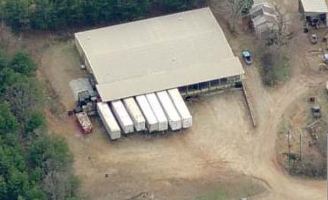
828 Saint Mark Rd
Greenville-Anderson-Greer, SC
Plat For Hofden Llc
T009.01-01-016.00
MAP T009.01; B
Warehouse
Greenville
X
South Carolina
45045C0333E
016.00
2025
1.50 AC
2024
Rt 29 Rutherford Rd
002611
Greenville/Spartanburg
DEMOGRAPHICS near 828 Saint Mark Rd
1 Mile
3 Mile
5 Mile
2024 Total Population
3,594
32,241
105,407
2029 Population
3,968
35,473
116,016
Pop Growth 2024-2029
+ 10.41%
+ 10.02%
+ 10.06%
Average Age
42
41
40
2024 Total Households
1,425
12,716
41,755
HH Growth 2024-2029
+ 10.46%
+ 10.12%
+ 10.15%
Median Household Inc
$53,257
$68,507
$70,180
Avg Household Size
2.40
2.50
2.50
2024 Avg HH Vehicles
2.00
2.00
2.00
Median Home Value
$232,713
$230,387
$243,797
Median Year Built
1995
1990
1989
Nearby Places
Map Layers
Map Styles
 Street
 Aerial
- Restaurants
- Banks
- Shops
- Fitness
- Groceries
PUBLIC TRANSPORTATION
AIRPORT
Greenville Spartanburg International
DRIVE
WALK
Distance
Greenville Spartanburg International
15 min
7.5 mi
Asheville Regional
DRIVE
WALK
Distance
Asheville Regional
61 min
44.7 mi
SALE & LEASE HISTORY
LISTING DATE
SALE/LEASE

Jul 27, 2017
For Sale
Jul 10, 2017
For Sale
Nearby Properties
Address
Land Use
TOTAL SIZE
Lot Size
Zoning
Address
Land Use
TOTAL SIZE
Lot Size
Zoning
13.25 AC
I1
Address
Land Use
TOTAL SIZE
Lot Size
Zoning
11.80 AC
R10
Address
Land Use
TOTAL SIZE
Lot Size
Zoning
11.30 AC
R10
Address
Land Use
TOTAL SIZE
Lot Size
Zoning
8.22 AC
I1
Address
Land Use
TOTAL SIZE
Lot Size
Zoning
1.90 AC
I1
Address
Land Use
TOTAL SIZE
Lot Size
Zoning
25.70 AC
R20
Address
Land Use
TOTAL SIZE
Lot Size
Zoning
10.20 AC
S1
Address
Land Use
TOTAL SIZE
Lot Size
Zoning
41.90 AC
RMA
Address
Land Use
TOTAL SIZE
Lot Size
Zoning
14.33 AC
I1
Address
Land Use
TOTAL SIZE
Lot Size
Zoning
22.35 AC
R20
Address
Land Use
TOTAL SIZE
Lot Size
Zoning
99.01 AC
I1
Address
Land Use
TOTAL SIZE
Lot Size
Zoning
1.03 AC
RM
Address
Land Use
TOTAL SIZE
Lot Size
Zoning
82.10 AC
S1
Address
Land Use
TOTAL SIZE
Lot Size
Zoning
9.14 AC
R75
Address
Land Use
TOTAL SIZE
Lot Size
Zoning
3.11 AC
I1
Address
Land Use
TOTAL SIZE
Lot Size
Zoning
12 AC
RM
Address
Land Use
TOTAL SIZE
Lot Size
Zoning
12.30 AC
I1
Address
Land Use
TOTAL SIZE
Lot Size
Zoning
15.40 AC
I1
Address
Land Use
TOTAL SIZE
Lot Size
Zoning
1.70 AC
R75
Address
Land Use
TOTAL SIZE
Lot Size
Zoning
17.32 AC
C3
Address
Land Use
TOTAL SIZE
Lot Size
Zoning
5.05 AC
C2
Address
Land Use
TOTAL SIZE
Lot Size
Zoning
51.60 AC
R15
Address
Land Use
TOTAL SIZE
Lot Size
Zoning
2.04 AC
S1
Address
Land Use
TOTAL SIZE
Lot Size
Zoning
1.93 AC
R20
Address
Land Use
TOTAL SIZE
Lot Size
Zoning
3.60 AC
R20
Address
Land Use
TOTAL SIZE
Lot Size
Zoning
0.86 AC
OD
Address
Land Use
TOTAL SIZE
Lot Size
Zoning
17.33 AC
C3
Address
Land Use
TOTAL SIZE
Lot Size
Zoning
12.47 AC
C3
Address
Land Use
TOTAL SIZE
Lot Size
Zoning
3.65 AC
PDR
Address
Land Use
TOTAL SIZE
Lot Size
Zoning
3.10 AC
C2
The World's #1 Commercial Real Estate Marketplace
Connect with us
© 2026 CoStar Group
The information above has been obtained from sources believed reliable. While we do not doubt its accuracy we have not verified it and make no guarantee, warranty or representation about it. It is your responsibility to independently confirm its accuracy and completeness. Any projections, opinions, assumptions, or estimates used are for example only and do not represent the current or future performance of the property. The value of this transaction to you depends on tax and other factors which should be evaluated by your tax, financial, and legal advisors. You and your advisors should conduct a careful, independent investigation of the property to determine to your satisfaction the suitability of the property for your needs.