Property Record
8282 I 10 Service Rd, New Orleans, LA 70126
NEARBY LISTINGS FOR SALE OR LEASE
-
-
View all New Orleans listings for sale on LoopNet.com
Property Detail
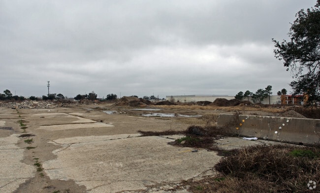
8282 I 10 Service Rd
New Orleans-Metairie, LA
Sec 22
3-9W-0-161-23
SQ SEC 22 PARCEL 6C-1 896-133 50/901 X 1153-141/979 VACANT 21.58 ACRES PL (SEE E2),8300 I10 SERV RD
Religious
Orleans
AE
Louisiana
22087C0225D
6
0
21.58 AC
2025
West Lake Forest
001756
New Orleans/Metairie/Kenner
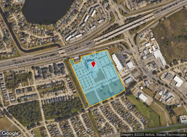
DEMOGRAPHICS near 8282 I 10 Service Rd
1 Mile
3 Mile
5 Mile
2024 Total Population
18,747
55,746
124,458
2029 Population
17,884
53,151
119,336
Pop Growth 2024-2029
(4.60%)
(4.66%)
(4.12%)
Average Age
37
39
39
2024 Total Households
6,800
20,592
47,174
HH Growth 2024-2029
(5.07%)
(4.95%)
(4.39%)
Median Household Inc
$29,022
$33,328
$36,464
Avg Household Size
2.60
2.60
2.50
2024 Avg HH Vehicles
1.00
1.00
1.00
Median Home Value
$178,361
$179,861
$191,409
Median Year Built
1976
1975
1971
Nearby Places
Map Layers
Map Styles
 Street
 Aerial
- Restaurants
- Banks
- Shops
- Fitness
- Groceries
PUBLIC TRANSPORTATION
COMMUTER RAIL
New Orleans Union Passenger Terminal (City of New Orleans - Amtrak, Crescent - Amtrak, Sunset Limited - Amtrak)
DRIVE
WALK
Distance
New Orleans Union Passenger Terminal (City of New Orleans - Amtrak, Crescent - Amtrak, Sunset Limited - Amtrak)
16 min
9.4 mi
AIRPORT
Louis Armstrong New Orleans International
DRIVE
WALK
Distance
Louis Armstrong New Orleans International
29 min
19.5 mi
Freight Ports
Port of New Orleans
DRIVE
WALK
Distance
Port of New Orleans
23 min
11.8 mi
Nearby Properties
Address
Land Use
TOTAL SIZE
Lot Size
Zoning
Address
Land Use
TOTAL SIZE
Lot Size
Zoning
Address
Land Use
TOTAL SIZE
Lot Size
Zoning
21.35 AC
S-RS
Address
Land Use
TOTAL SIZE
Lot Size
Zoning
484,670 SF
18.69 AC
EC
Address
Land Use
TOTAL SIZE
Lot Size
Zoning
183.59 AC
OS-R
Address
Land Use
TOTAL SIZE
Lot Size
Zoning
136,984 SF
11.29 AC
S-RD
Address
Land Use
TOTAL SIZE
Lot Size
Zoning
136,984 SF
4.67 AC
S-RS
Address
Land Use
TOTAL SIZE
Lot Size
Zoning
109,239 SF
5.77 AC
S-RS
Address
Land Use
TOTAL SIZE
Lot Size
Zoning
115,600 SF
16.96 AC
S-B2
Address
Land Use
TOTAL SIZE
Lot Size
Zoning
31,894 SF
500 AC
MI
Address
Land Use
TOTAL SIZE
Lot Size
Zoning
210,959 SF
6.61 AC
EC
Address
Land Use
TOTAL SIZE
Lot Size
Zoning
13.23 AC
MI
Address
Land Use
TOTAL SIZE
Lot Size
Zoning
95,308 SF
16.36 AC
S-RS
Address
Land Use
TOTAL SIZE
Lot Size
Zoning
99,015 SF
6.99 AC
S-RS
Address
Land Use
TOTAL SIZE
Lot Size
Zoning
94,050 SF
4.96 AC
S-RS
Address
Land Use
TOTAL SIZE
Lot Size
Zoning
98,500 SF
5.54 AC
S-RS
Address
Land Use
TOTAL SIZE
Lot Size
Zoning
105,907 SF
3.84 AC
OS-N
Address
Land Use
TOTAL SIZE
Lot Size
Zoning
13,302 SF
53.89 AC
OS-R
Address
Land Use
TOTAL SIZE
Lot Size
Zoning
179,095 SF
18.13 AC
C-3
Address
Land Use
TOTAL SIZE
Lot Size
Zoning
2.48 AC
S-RD
Address
Land Use
TOTAL SIZE
Lot Size
Zoning
205,380 SF
16.49 AC
MS
Address
Land Use
TOTAL SIZE
Lot Size
Zoning
13,563 SF
81.46 AC
OS-R
Address
Land Use
TOTAL SIZE
Lot Size
Zoning
17.83 AC
OS-R
Address
Land Use
TOTAL SIZE
Lot Size
Zoning
93,584 SF
20.96 AC
S-RS
Address
Land Use
TOTAL SIZE
Lot Size
Zoning
20.48 AC
S-RS
Address
Land Use
TOTAL SIZE
Lot Size
Zoning
280,168 SF
11.47 AC
S-RM2
Address
Land Use
TOTAL SIZE
Lot Size
Zoning
2.32 AC
C-3
Address
Land Use
TOTAL SIZE
Lot Size
Zoning
5.92 AC
C-1
Address
Land Use
TOTAL SIZE
Lot Size
Zoning
43,792 SF
0.89 AC
C-2
Address
Land Use
TOTAL SIZE
Lot Size
Zoning
147,600 SF
14.18 AC
C-3
The World's #1 Commercial Real Estate Marketplace
Connect with us
© 2026 CoStar Group
The information above has been obtained from sources believed reliable. While we do not doubt its accuracy we have not verified it and make no guarantee, warranty or representation about it. It is your responsibility to independently confirm its accuracy and completeness. Any projections, opinions, assumptions, or estimates used are for example only and do not represent the current or future performance of the property. The value of this transaction to you depends on tax and other factors which should be evaluated by your tax, financial, and legal advisors. You and your advisors should conduct a careful, independent investigation of the property to determine to your satisfaction the suitability of the property for your needs.