Property Record
8285 E Shields Ave, Fresno, CA 93737
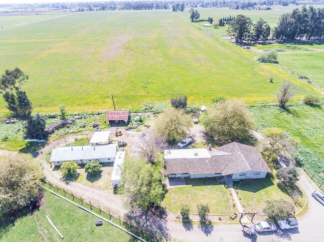

Property Detail
8285 E Shields Ave
310-310-05
20 AC W1/2 OF LOTS 9 10 KUTNER COL SEC 25 T13R21
Pasture
FRESNO
AE20
California
AE The base floodplain where base flood elevations are provided. AE Zones are now used on new format FIRMs instead of A1-A30 Zones.
10
2025
20 AC
2025
E Outlying Fresno County
005904
Fresno
2,473 SF
Fresno, CA
NEARBY LISTINGS FOR SALE OR LEASE
DEMOGRAPHICS near 8285 E Shields Ave
1 mile
3 mile
5 mile
2025 Total Population
4,539
59,455
159,059
2030 Population
4,707
61,328
162,546
Pop Growth 2025-2030
+ 3.70%
+ 3.15%
+ 2.19%
Average Age
36
37
37
2025 Total Households
1,429
18,228
51,745
HH Growth 2025-2030
+ 3.71%
+ 3.11%
+ 2.11%
Median Household Inc
$118,584
$121,638
$93,183
Avg Household Size
3.20
3.20
3.00
2025 Avg HH Vehicles
2.00
2.00
2.00
Median Home Value
$497,953
$537,223
$458,821
Median Year Built
2010
2008
1990
Nearby Places
Map Layers
Map Styles
 Street
 Aerial
Transit
 Traffic
 Biking
Places
Listings with unknown addresses are not visible on the map
- Restaurants
- Banks
- Shops
- Fitness
- Groceries
PUBLIC TRANSPORTATION
AIRPORT
Fresno Yosemite International
Drive
Walk
Distance
Fresno Yosemite International
13 min
6.5 mi
Freight Ports
Port of Stockton
Drive
Walk
Distance
Port of Stockton
167 min
138.0 mi
SALE & LEASE HISTORY
LISTING DATE
SALE/LEASE

Sep 13, 2019
For Sale
Jul 10, 2023
For Sale
Nearby Properties
Address
Land Use
TOTAL SIZE
Lot Size
Zoning
Address
Land Use
TOTAL SIZE
Lot Size
Zoning
202,149 SF
27.56 AC
SPLIT
Address
Land Use
TOTAL SIZE
Lot Size
Zoning
93,172 SF
4.97 AC
Address
Land Use
TOTAL SIZE
Lot Size
Zoning
102,765 SF
8.90 AC
M1
Address
Land Use
TOTAL SIZE
Lot Size
Zoning
226,937 SF
20.15 AC
SPLIT
Address
Land Use
TOTAL SIZE
Lot Size
Zoning
226,937 SF
11.52 AC
Address
Land Use
TOTAL SIZE
Lot Size
Zoning
76,720 SF
10.78 AC
Address
Land Use
TOTAL SIZE
Lot Size
Zoning
55,383 SF
5.27 AC
PCC
Address
Land Use
TOTAL SIZE
Lot Size
Zoning
59,188 SF
3.15 AC
R2
Address
Land Use
TOTAL SIZE
Lot Size
Zoning
55,159 SF
3.89 AC
PCC
Address
Land Use
TOTAL SIZE
Lot Size
Zoning
71,377 SF
4.37 AC
RS1
Address
Land Use
TOTAL SIZE
Lot Size
Zoning
37,392 SF
6.87 AC
RA
Address
Land Use
TOTAL SIZE
Lot Size
Zoning
150,080 SF
7.99 AC
M1
Address
Land Use
TOTAL SIZE
Lot Size
Zoning
25,600 SF
1.99 AC
IL
Address
Land Use
TOTAL SIZE
Lot Size
Zoning
224,875 SF
21.48 AC
Address
Land Use
TOTAL SIZE
Lot Size
Zoning
158.81 AC
AE20
Address
Land Use
TOTAL SIZE
Lot Size
Zoning
32,381 SF
24.07 AC
Address
Land Use
TOTAL SIZE
Lot Size
Zoning
5,796 SF
1.46 AC
PCC
Address
Land Use
TOTAL SIZE
Lot Size
Zoning
15,748 SF
1.91 AC
C2
Address
Land Use
TOTAL SIZE
Lot Size
Zoning
8.30 AC
A2
Address
Land Use
TOTAL SIZE
Lot Size
Zoning
130,687 SF
7.15 AC
RA
Address
Land Use
TOTAL SIZE
Lot Size
Zoning
32,381 SF
14.95 AC
RA
Address
Land Use
TOTAL SIZE
Lot Size
Zoning
29,759 SF
2.33 AC
M1
Address
Land Use
TOTAL SIZE
Lot Size
Zoning
32,070 SF
109.34 AC
RR
Address
Land Use
TOTAL SIZE
Lot Size
Zoning
73,577 SF
25.18 AC
AE20
Address
Land Use
TOTAL SIZE
Lot Size
Zoning
19,800 SF
2.19 AC
Address
Land Use
TOTAL SIZE
Lot Size
Zoning
3,370 SF
0.99 AC
CM
Address
Land Use
TOTAL SIZE
Lot Size
Zoning
12,500 SF
4.68 AC
R1
The World's #1 Commercial Real Estate Marketplace
Connect with us
© 2026 CoStar Group
The information above has been obtained from sources believed reliable. While we do not doubt its accuracy we have not verified it and make no guarantee, warranty or representation about it. It is your responsibility to independently confirm its accuracy and completeness. Any projections, opinions, assumptions, or estimates used are for example only and do not represent the current or future performance of the property. The value of this transaction to you depends on tax and other factors which should be evaluated by your tax, financial, and legal advisors. You and your advisors should conduct a careful, independent investigation of the property to determine to your satisfaction the suitability of the property for your needs.