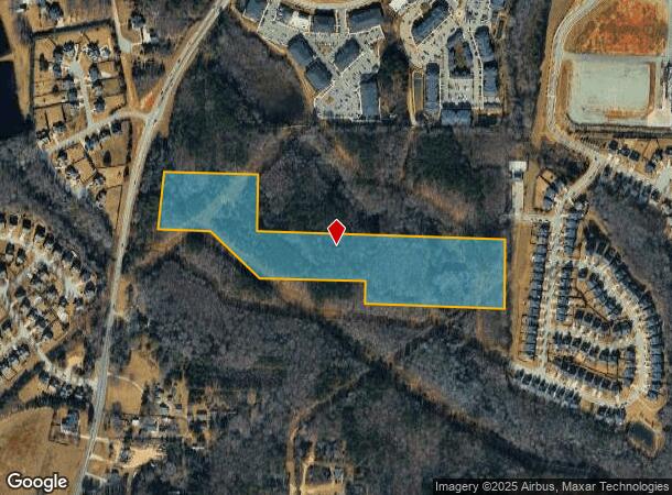
Property Record
829 Piney Grove Wilbon Rd, Holly Springs, NC 27540
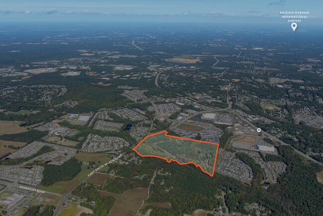

This Property Is For Sale
NEARBY LISTINGS FOR SALE OR LEASE
Property Detail
829 Piney Grove Wilbon Rd
Raleigh, NC
Division/Land/Edith Page
0648.04-83-7540-000
REEDY CRK LAND
Vacantlandnec
Wake
X
North Carolina
3720064800K
2
2025
15 AC
2025
Southwest Wake County
053206
Raleigh/Durham
DEMOGRAPHICS near 829 Piney Grove Wilbon Rd
1 Mile
3 Mile
5 Mile
2024 Total Population
5,310
48,267
101,633
2029 Population
5,872
52,982
111,718
Pop Growth 2024-2029
+ 10.58%
+ 9.77%
+ 9.92%
Average Age
36
37
37
2024 Total Households
1,805
16,281
34,742
HH Growth 2024-2029
+ 10.47%
+ 9.70%
+ 9.91%
Median Household Inc
$116,696
$113,459
$109,147
Avg Household Size
2.90
2.90
2.90
2024 Avg HH Vehicles
2.00
2.00
2.00
Median Home Value
$408,759
$412,719
$400,385
Median Year Built
2010
2007
2005
Nearby Places
- Restaurants
- Banks
- Shops
- Fitness
- Groceries
PUBLIC TRANSPORTATION
AIRPORT
Raleigh-Durham International
DRIVE
WALK
Distance
Raleigh-Durham International
33 min
24.7 mi
Freight Ports
Port of Wilmington
DRIVE
WALK
Distance
Port of Wilmington
160 min
132.0 mi
Nearby Properties
Address
Land Use
TOTAL SIZE
Lot Size
Zoning
Address
Land Use
TOTAL SIZE
Lot Size
Zoning
898,348 SF
147.52 AC
BRT
Address
Land Use
TOTAL SIZE
Lot Size
Zoning
600,780 SF
157.91 AC
PUD
Address
Land Use
TOTAL SIZE
Lot Size
Zoning
553,292 SF
91.44 AC
RR
Address
Land Use
TOTAL SIZE
Lot Size
Zoning
295,615 SF
38.04 AC
SP
Address
Land Use
TOTAL SIZE
Lot Size
Zoning
378,367 SF
26.21 AC
RHD-C
Address
Land Use
TOTAL SIZE
Lot Size
Zoning
313,307 SF
21.58 AC
MXR
Address
Land Use
TOTAL SIZE
Lot Size
Zoning
311,701 SF
19.97 AC
RHD
Address
Land Use
TOTAL SIZE
Lot Size
Zoning
301,882 SF
19.44 AC
MXR
Address
Land Use
TOTAL SIZE
Lot Size
Zoning
244,266 SF
11.74 AC
PUD
Address
Land Use
TOTAL SIZE
Lot Size
Zoning
242,251 SF
35.55 AC
SR
Address
Land Use
TOTAL SIZE
Lot Size
Zoning
201,371 SF
9.68 AC
O&I
Address
Land Use
TOTAL SIZE
Lot Size
Zoning
208,323 SF
36.14 AC
CB
Address
Land Use
TOTAL SIZE
Lot Size
Zoning
230,176 SF
16.83 AC
MXR
Address
Land Use
TOTAL SIZE
Lot Size
Zoning
213,912 SF
16.33 AC
MXR
Address
Land Use
TOTAL SIZE
Lot Size
Zoning
208,958 SF
14.34 AC
MXR
Address
Land Use
TOTAL SIZE
Lot Size
Zoning
1,323.42 AC
R-80
Address
Land Use
TOTAL SIZE
Lot Size
Zoning
221,860 SF
40.32 AC
PUD
Address
Land Use
TOTAL SIZE
Lot Size
Zoning
159,046 SF
6.47 AC
CB
Address
Land Use
TOTAL SIZE
Lot Size
Zoning
154,305 SF
12.87 AC
NMX
Address
Land Use
TOTAL SIZE
Lot Size
Zoning
124,660 SF
40.81 AC
RR
Address
Land Use
TOTAL SIZE
Lot Size
Zoning
140,774 SF
8.56 AC
MXR
Address
Land Use
TOTAL SIZE
Lot Size
Zoning
95,819 SF
22.63 AC
NR
Address
Land Use
TOTAL SIZE
Lot Size
Zoning
83,117 SF
9.74 AC
NR
Address
Land Use
TOTAL SIZE
Lot Size
Zoning
149,526 SF
10.91 AC
HI
Address
Land Use
TOTAL SIZE
Lot Size
Zoning
145,707 SF
15.40 AC
PUD
Address
Land Use
TOTAL SIZE
Lot Size
Zoning
340,556 SF
33.92 AC
RLI
Address
Land Use
TOTAL SIZE
Lot Size
Zoning
180,595 SF
35.61 AC
CB
Address
Land Use
TOTAL SIZE
Lot Size
Zoning
72,096 SF
5.51 AC
NMX
Address
Land Use
TOTAL SIZE
Lot Size
Zoning
86,659 SF
10.08 AC
CB
Address
Land Use
TOTAL SIZE
Lot Size
Zoning
93,174 SF
9.07 AC
PUD
The World's #1 Commercial Real Estate Marketplace
Connect with us
© 2025 CoStar Group
The information above has been obtained from sources believed reliable. While we do not doubt its accuracy we have not verified it and make no guarantee, warranty or representation about it. It is your responsibility to independently confirm its accuracy and completeness. Any projections, opinions, assumptions, or estimates used are for example only and do not represent the current or future performance of the property. The value of this transaction to you depends on tax and other factors which should be evaluated by your tax, financial, and legal advisors. You and your advisors should conduct a careful, independent investigation of the property to determine to your satisfaction the suitability of the property for your needs.