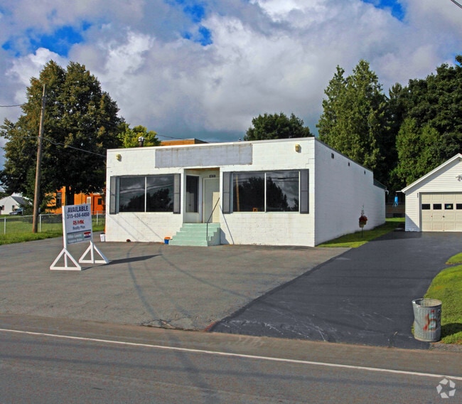
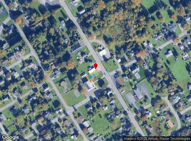
Property Record
829 State Fair Blvd, Syracuse, NY 13209

NEARBY LISTINGS FOR SALE OR LEASE
Property Detail
829 State Fair Blvd
313289-023-000-0011-014-000-0000
FL 22 (LAKELAND HOME SUPP 1126211
Vehiclerentalsvehiclesales
Onondaga
X
New York
36067C0203F
14.000
2025
0.11 AC
2024
W Outer Onondaga County
012800
Syracuse
1,632 SF
Syracuse, NY
DEMOGRAPHICS near 829 State Fair Blvd
1 Mile
3 Mile
5 Mile
2024 Total Population
2,716
29,075
123,082
2029 Population
2,634
28,379
119,754
Pop Growth 2024-2029
(3.02%)
(2.39%)
(2.70%)
Average Age
45
42
41
2024 Total Households
1,141
12,874
53,325
HH Growth 2024-2029
(3.07%)
(2.63%)
(2.89%)
Median Household Inc
$72,475
$64,184
$63,199
Avg Household Size
2.30
2.20
2.20
2024 Avg HH Vehicles
2.00
2.00
2.00
Median Home Value
$148,548
$152,145
$155,710
Median Year Built
1970
1964
1961
Nearby Places
- Restaurants
- Banks
- Shops
- Fitness
- Groceries
PUBLIC TRANSPORTATION
COMMUTER RAIL
DRIVE
WALK
Distance
8 min
3.8 mi
DRIVE
WALK
Distance
11 min
5.7 mi
AIRPORT
Syracuse Hancock International
DRIVE
WALK
Distance
Syracuse Hancock International
18 min
10.3 mi
Nearby Properties
Address
Land Use
TOTAL SIZE
Lot Size
Zoning
Address
Land Use
TOTAL SIZE
Lot Size
Zoning
52,800 SF
691.95 AC
06 - INDUS
Address
Land Use
TOTAL SIZE
Lot Size
Zoning
6,106 SF
32.71 AC
06
Address
Land Use
TOTAL SIZE
Lot Size
Zoning
22,692 SF
28.07 AC
03 - MULTI
Address
Land Use
TOTAL SIZE
Lot Size
Zoning
7,392 SF
14.86 AC
03 - MULTI
Address
Land Use
TOTAL SIZE
Lot Size
Zoning
257,617 SF
50.74 AC
INA
Address
Land Use
TOTAL SIZE
Lot Size
Zoning
216,079 SF
17.57 AC
06 - INDUS
Address
Land Use
TOTAL SIZE
Lot Size
Zoning
77,150 SF
159.25 AC
06 - INDUS
Address
Land Use
TOTAL SIZE
Lot Size
Zoning
151,326 SF
9.23 AC
05 - COMME
Address
Land Use
TOTAL SIZE
Lot Size
Zoning
3,968 SF
14.31 AC
03 - MULTI
Address
Land Use
TOTAL SIZE
Lot Size
Zoning
163,725 SF
21.46 AC
02 - SINGL
Address
Land Use
TOTAL SIZE
Lot Size
Zoning
7,229 SF
111.29 AC
05 - COMME
Address
Land Use
TOTAL SIZE
Lot Size
Zoning
11,952 SF
9.14 AC
03 - MULTI
Address
Land Use
TOTAL SIZE
Lot Size
Zoning
65,027 SF
262.57 AC
06 - INDUS
Address
Land Use
TOTAL SIZE
Lot Size
Zoning
71,074 SF
27.78 AC
02 - SINGL
Address
Land Use
TOTAL SIZE
Lot Size
Zoning
157,675 SF
12.88 AC
Address
Land Use
TOTAL SIZE
Lot Size
Zoning
32,586 SF
6.87 AC
06 - INDUS
Address
Land Use
TOTAL SIZE
Lot Size
Zoning
57,993 SF
18.43 AC
02 - SINGL
Address
Land Use
TOTAL SIZE
Lot Size
Zoning
13,032 SF
7.63 AC
Address
Land Use
TOTAL SIZE
Lot Size
Zoning
17,240 SF
6.49 AC
03 - MULTI
Address
Land Use
TOTAL SIZE
Lot Size
Zoning
3,744 SF
10.60 AC
03 - MULTI
Address
Land Use
TOTAL SIZE
Lot Size
Zoning
3,696 SF
10.12 AC
03 - MULTI
Address
Land Use
TOTAL SIZE
Lot Size
Zoning
2,624 SF
252.09 AC
06 - INDUS
Address
Land Use
TOTAL SIZE
Lot Size
Zoning
114,396 SF
9.98 AC
05 - COMME
Address
Land Use
TOTAL SIZE
Lot Size
Zoning
71,194 SF
10.76 AC
02 - SINGL
Address
Land Use
TOTAL SIZE
Lot Size
Zoning
114,450 SF
14.26 AC
06 - INDUS
Address
Land Use
TOTAL SIZE
Lot Size
Zoning
43,664 SF
1.87 AC
Address
Land Use
TOTAL SIZE
Lot Size
Zoning
210,170 SF
17.87 AC
06 - INDUS
Address
Land Use
TOTAL SIZE
Lot Size
Zoning
2,028 SF
9.60 AC
05 - COMME
Address
Land Use
TOTAL SIZE
Lot Size
Zoning
381,465 SF
62.82 AC
06 - INDUS
Address
Land Use
TOTAL SIZE
Lot Size
Zoning
57,723 SF
4.77 AC
06 - INDUS
The World's #1 Commercial Real Estate Marketplace
Connect with us
© 2025 CoStar Group
The information above has been obtained from sources believed reliable. While we do not doubt its accuracy we have not verified it and make no guarantee, warranty or representation about it. It is your responsibility to independently confirm its accuracy and completeness. Any projections, opinions, assumptions, or estimates used are for example only and do not represent the current or future performance of the property. The value of this transaction to you depends on tax and other factors which should be evaluated by your tax, financial, and legal advisors. You and your advisors should conduct a careful, independent investigation of the property to determine to your satisfaction the suitability of the property for your needs.