Property Record
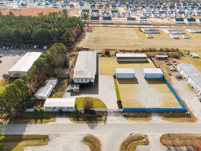
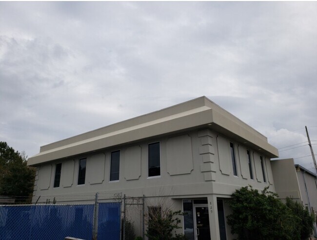
829 W Star St, Greenville, NC 27834
NEARBY LISTINGS FOR SALE OR LEASE
Property Detail
829 W Star St
050067
WEST STAR INDUSTRIAL PARK
Warehouse
Pitt
X
North Carolina
3720466600J
12
2025
1.46 AC
2025
Southwest Greenville
000607
Other Market Areas
11,464 SF
Greenville, NC
DEMOGRAPHICS near 829 W Star St
1 Mile
3 Mile
5 Mile
2024 Total Population
3,721
35,116
86,889
2029 Population
3,932
36,790
91,256
Pop Growth 2024-2029
+ 5.67%
+ 4.77%
+ 5.03%
Average Age
36
36
36
2024 Total Households
1,384
14,971
36,701
HH Growth 2024-2029
+ 5.92%
+ 5.06%
+ 5.49%
Median Household Inc
$70,306
$47,543
$46,308
Avg Household Size
2.60
2.30
2.20
2024 Avg HH Vehicles
2.00
2.00
2.00
Median Home Value
$188,317
$169,241
$179,992
Median Year Built
2005
1999
1996
Nearby Places
Map Layers
Map Styles
 Street
 Aerial
- Restaurants
- Banks
- Shops
- Fitness
- Groceries
PUBLIC TRANSPORTATION
AIRPORT
Pitt-Greenville
DRIVE
WALK
Distance
Pitt-Greenville
17 min
11.4 mi
Freight Ports
Port of Morehead City
DRIVE
WALK
Distance
Port of Morehead City
132 min
87.3 mi
SALE & LEASE HISTORY
LISTING DATE
SALE/LEASE

Mar 24, 2023
For Sale
Dec 08, 2017
For Lease
Nearby Properties
Address
Land Use
TOTAL SIZE
Lot Size
Zoning
Address
Land Use
TOTAL SIZE
Lot Size
Zoning
251,145 SF
84.25 AC
RA20
Address
Land Use
TOTAL SIZE
Lot Size
Zoning
142,831 SF
13.61 AC
MO
Address
Land Use
TOTAL SIZE
Lot Size
Zoning
18,932 SF
11.51 AC
MR
Address
Land Use
TOTAL SIZE
Lot Size
Zoning
90,108 SF
11.27 AC
OI
Address
Land Use
TOTAL SIZE
Lot Size
Zoning
162,126 SF
30 AC
OI
Address
Land Use
TOTAL SIZE
Lot Size
Zoning
23,772 SF
8.75 AC
MR
Address
Land Use
TOTAL SIZE
Lot Size
Zoning
94,176 SF
23.12 AC
R6
Address
Land Use
TOTAL SIZE
Lot Size
Zoning
97,638 SF
28.62 AC
R9S
Address
Land Use
TOTAL SIZE
Lot Size
Zoning
64,547 SF
28.84 AC
MO
Address
Land Use
TOTAL SIZE
Lot Size
Zoning
63,504 SF
15.20 AC
CG
Address
Land Use
TOTAL SIZE
Lot Size
Zoning
118,668 SF
9.49 AC
CH
Address
Land Use
TOTAL SIZE
Lot Size
Zoning
26,958 SF
7.67 AC
MR
Address
Land Use
TOTAL SIZE
Lot Size
Zoning
84,649 SF
44.78 AC
AR
Address
Land Use
TOTAL SIZE
Lot Size
Zoning
30,714 SF
7.79 AC
MR
Address
Land Use
TOTAL SIZE
Lot Size
Zoning
75,300 SF
8.64 AC
GB
Address
Land Use
TOTAL SIZE
Lot Size
Zoning
56,748 SF
1.72 AC
OI
Address
Land Use
TOTAL SIZE
Lot Size
Zoning
27,466 SF
7.57 AC
MR
Address
Land Use
TOTAL SIZE
Lot Size
Zoning
54,430 SF
39.09 AC
RA20
Address
Land Use
TOTAL SIZE
Lot Size
Zoning
45,471 SF
10.69 AC
MO
Address
Land Use
TOTAL SIZE
Lot Size
Zoning
9,864 SF
19 AC
R6A
Address
Land Use
TOTAL SIZE
Lot Size
Zoning
58,705 SF
1.81 AC
CG
Address
Land Use
TOTAL SIZE
Lot Size
Zoning
8,736 SF
6.91 AC
MR
Address
Land Use
TOTAL SIZE
Lot Size
Zoning
45,180 SF
7.16 AC
MO
Address
Land Use
TOTAL SIZE
Lot Size
Zoning
5,370 SF
8.19 AC
R6
Address
Land Use
TOTAL SIZE
Lot Size
Zoning
170,143 SF
11.76 AC
CG
Address
Land Use
TOTAL SIZE
Lot Size
Zoning
42,124 SF
22.38 AC
OI
Address
Land Use
TOTAL SIZE
Lot Size
Zoning
8,736 SF
6.15 AC
MR
Address
Land Use
TOTAL SIZE
Lot Size
Zoning
55,020 SF
5.07 AC
CG
Address
Land Use
TOTAL SIZE
Lot Size
Zoning
19,314 SF
8.99 AC
R6
Address
Land Use
TOTAL SIZE
Lot Size
Zoning
137,320 SF
13.58 AC
GB
The World's #1 Commercial Real Estate Marketplace
Connect with us
© 2025 CoStar Group
The information above has been obtained from sources believed reliable. While we do not doubt its accuracy we have not verified it and make no guarantee, warranty or representation about it. It is your responsibility to independently confirm its accuracy and completeness. Any projections, opinions, assumptions, or estimates used are for example only and do not represent the current or future performance of the property. The value of this transaction to you depends on tax and other factors which should be evaluated by your tax, financial, and legal advisors. You and your advisors should conduct a careful, independent investigation of the property to determine to your satisfaction the suitability of the property for your needs.