Property Record
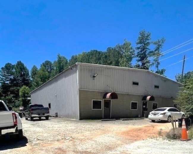
8290 Lee Rd, Lithia Springs, GA 30122


NEARBY LISTINGS FOR SALE OR LEASE
Property Detail
8290 Lee Rd
Atlanta-Sandy Springs-Roswell, GA
Douglas County
0182-08-9-0-004
BLDG/2.00 ACRES, LEE ROAD
Industrialgeneral
Douglas
X
Georgia
13097C0069D
890
2024
2 AC
2024
I-20 W/Douglasville
080602
Atlanta
7,000 SF
DEMOGRAPHICS near 8290 Lee Rd
1 Mile
3 Mile
5 Mile
2024 Total Population
4,591
30,629
90,856
2029 Population
4,848
32,190
94,771
Pop Growth 2024-2029
+ 5.60%
+ 5.10%
+ 4.31%
Average Age
38
38
37
2024 Total Households
1,678
11,578
33,107
HH Growth 2024-2029
+ 5.84%
+ 5.04%
+ 4.30%
Median Household Inc
$61,667
$60,531
$62,399
Avg Household Size
2.70
2.60
2.70
2024 Avg HH Vehicles
2.00
2.00
2.00
Median Home Value
$159,999
$191,791
$207,518
Median Year Built
1985
1992
1993
Nearby Places
Map Layers
Map Styles
 Street
 Aerial
- Restaurants
- Banks
- Shops
- Fitness
- Groceries
PUBLIC TRANSPORTATION
AIRPORT
Hartsfield - Jackson Atlanta International
DRIVE
WALK
Distance
Hartsfield - Jackson Atlanta International
35 min
25.3 mi
Freight Ports
Georgia Ports - Savannah
DRIVE
WALK
Distance
Georgia Ports - Savannah
298 min
264.6 mi
SALE & LEASE HISTORY
LISTING DATE
SALE/LEASE

Jul 09, 2024
For Sale
Nearby Properties
Address
Land Use
TOTAL SIZE
Lot Size
Zoning
Address
Land Use
TOTAL SIZE
Lot Size
Zoning
320,073 SF
38.78 AC
R-MF
Address
Land Use
TOTAL SIZE
Lot Size
Zoning
417,860 SF
40.32 AC
LI
Address
Land Use
TOTAL SIZE
Lot Size
Zoning
75,628 SF
290.39 AC
DCD
Address
Land Use
TOTAL SIZE
Lot Size
Zoning
709,289 SF
112.06 AC
DCD
Address
Land Use
TOTAL SIZE
Lot Size
Zoning
330,754 SF
27.25 AC
R-6
Address
Land Use
TOTAL SIZE
Lot Size
Zoning
318,456 SF
30.91 AC
R-MF
Address
Land Use
TOTAL SIZE
Lot Size
Zoning
222,846 SF
50.74 AC
R-6
Address
Land Use
TOTAL SIZE
Lot Size
Zoning
205,390 SF
24.28 AC
Address
Land Use
TOTAL SIZE
Lot Size
Zoning
494,858 SF
43.29 AC
IL
Address
Land Use
TOTAL SIZE
Lot Size
Zoning
281,844 SF
38.66 AC
R-MF
Address
Land Use
TOTAL SIZE
Lot Size
Zoning
603,952 SF
37.71 AC
IL
Address
Land Use
TOTAL SIZE
Lot Size
Zoning
245,812 SF
30.90 AC
DCD
Address
Land Use
TOTAL SIZE
Lot Size
Zoning
490,726 SF
50.62 AC
LI-R
Address
Land Use
TOTAL SIZE
Lot Size
Zoning
527,000 SF
30.38 AC
LI
Address
Land Use
TOTAL SIZE
Lot Size
Zoning
314,792 SF
51.29 AC
DCD
Address
Land Use
TOTAL SIZE
Lot Size
Zoning
279,840 SF
44 AC
DCD
Address
Land Use
TOTAL SIZE
Lot Size
Zoning
635,664 SF
35.94 AC
5
Address
Land Use
TOTAL SIZE
Lot Size
Zoning
400,000 SF
66.21 AC
IL
Address
Land Use
TOTAL SIZE
Lot Size
Zoning
244,480 SF
92.83 AC
DCD
Address
Land Use
TOTAL SIZE
Lot Size
Zoning
380,000 SF
33.97 AC
IL
Address
Land Use
TOTAL SIZE
Lot Size
Zoning
310,689 SF
36.51 AC
LI
Address
Land Use
TOTAL SIZE
Lot Size
Zoning
181,768 SF
25 AC
R-MF
Address
Land Use
TOTAL SIZE
Lot Size
Zoning
312,093 SF
19.79 AC
PUD
Address
Land Use
TOTAL SIZE
Lot Size
Zoning
261,930 SF
21.83 AC
R-A
Address
Land Use
TOTAL SIZE
Lot Size
Zoning
261,794 SF
2.32 AC
DCD
Address
Land Use
TOTAL SIZE
Lot Size
Zoning
225,600 SF
50.68 AC
LI-R
Address
Land Use
TOTAL SIZE
Lot Size
Zoning
284,307 SF
15.75 AC
LI-R
Address
Land Use
TOTAL SIZE
Lot Size
Zoning
296,942 SF
72.27 AC
IL
Address
Land Use
TOTAL SIZE
Lot Size
Zoning
247,000 SF
17.77 AC
PUD
The World's #1 Commercial Real Estate Marketplace
Connect with us
© 2025 CoStar Group
The information above has been obtained from sources believed reliable. While we do not doubt its accuracy we have not verified it and make no guarantee, warranty or representation about it. It is your responsibility to independently confirm its accuracy and completeness. Any projections, opinions, assumptions, or estimates used are for example only and do not represent the current or future performance of the property. The value of this transaction to you depends on tax and other factors which should be evaluated by your tax, financial, and legal advisors. You and your advisors should conduct a careful, independent investigation of the property to determine to your satisfaction the suitability of the property for your needs.