Property Record
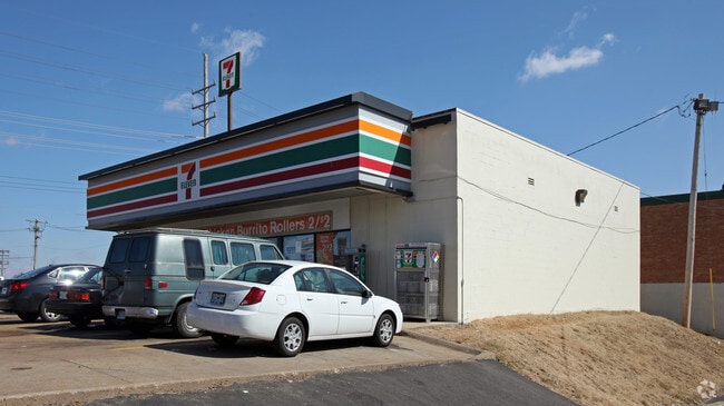
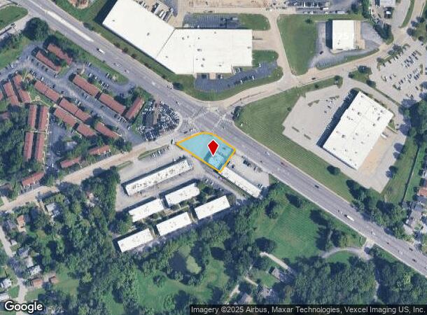
8290 Saint Charles Rock Rd, Saint Louis, MO 63114

NEARBY LISTINGS FOR SALE OR LEASE
Property Detail
8290 Saint Charles Rock Rd
15K-64-0103
LOC SW COR ST CHARLES ROCK RD & LACKLAND RD
Servicestation
St. Louis
X
Missouri
29189C0204K
0.48 AC
2024
Northwest County
2025
St. Louis
214300
St. Louis, MO-IL
2,585 SF
DEMOGRAPHICS near 8290 Saint Charles Rock Rd
1 Mile
3 Mile
5 Mile
2024 Total Population
10,382
98,691
277,248
2029 Population
10,331
98,146
275,401
Pop Growth 2024-2029
(0.49%)
(0.55%)
(0.67%)
Average Age
39
40
39
2024 Total Households
4,243
42,083
116,851
HH Growth 2024-2029
(0.66%)
(0.60%)
(0.73%)
Median Household Inc
$45,224
$46,454
$49,413
Avg Household Size
2.30
2.30
2.20
2024 Avg HH Vehicles
2.00
2.00
1.00
Median Home Value
$90,521
$101,762
$145,333
Median Year Built
1949
1953
1954
Nearby Places
Map Layers
Map Styles
 Street
 Aerial
- Restaurants
- Banks
- Shops
- Fitness
- Groceries
PUBLIC TRANSPORTATION
COMMUTER RAIL
North Hanley (Lambert Airport Shiloh-Scott - St. Louis MetroLink (MetroLink))
DRIVE
WALK
Distance
North Hanley (Lambert Airport Shiloh-Scott - St. Louis MetroLink (MetroLink))
4 min
2.3 mi
Um St. Louis South (Lambert Airport Shiloh-Scott - St. Louis MetroLink (MetroLink))
DRIVE
WALK
Distance
Um St. Louis South (Lambert Airport Shiloh-Scott - St. Louis MetroLink (MetroLink))
5 min
2.6 mi
AIRPORT
St Louis Lambert International
DRIVE
WALK
Distance
St Louis Lambert International
8 min
4.5 mi
Scott AFB/Midamerica St Louis
DRIVE
WALK
Distance
Scott AFB/Midamerica St Louis
54 min
36.9 mi
Freight Ports
Port Milwaukee
DRIVE
WALK
Distance
Port Milwaukee
429 min
379.0 mi
SALE & LEASE HISTORY
LISTING DATE
SALE/LEASE

Sep 23, 2022
For Sale
Nearby Properties
Address
Land Use
TOTAL SIZE
Lot Size
Zoning
Address
Land Use
TOTAL SIZE
Lot Size
Zoning
1,053,686 SF
31.40 AC
43M-1
Address
Land Use
TOTAL SIZE
Lot Size
Zoning
72,612 SF
118.34 AC
3INSTU
Address
Land Use
TOTAL SIZE
Lot Size
Zoning
378,915 SF
12.16 AC
73C
Address
Land Use
TOTAL SIZE
Lot Size
Zoning
19.40 AC
57PA
Address
Land Use
TOTAL SIZE
Lot Size
Zoning
348,233 SF
23.68 AC
Address
Land Use
TOTAL SIZE
Lot Size
Zoning
42.40 AC
M2
Address
Land Use
TOTAL SIZE
Lot Size
Zoning
309,486 SF
10.73 AC
7M-1
Address
Land Use
TOTAL SIZE
Lot Size
Zoning
231,336 SF
18.88 AC
7M-2
Address
Land Use
TOTAL SIZE
Lot Size
Zoning
136,258 SF
263.16 AC
7M-1
Address
Land Use
TOTAL SIZE
Lot Size
Zoning
277,926 SF
12.61 AC
67C-2
Address
Land Use
TOTAL SIZE
Lot Size
Zoning
14,371 SF
22.26 AC
84R-2
Address
Land Use
TOTAL SIZE
Lot Size
Zoning
18.32 AC
PA
Address
Land Use
TOTAL SIZE
Lot Size
Zoning
2.89 AC
F
Address
Land Use
TOTAL SIZE
Lot Size
Zoning
151,640 SF
5.38 AC
D
Address
Land Use
TOTAL SIZE
Lot Size
Zoning
0.73 AC
B
Address
Land Use
TOTAL SIZE
Lot Size
Zoning
5,640 SF
10.42 AC
A
Address
Land Use
TOTAL SIZE
Lot Size
Zoning
303,535 SF
16.44 AC
B
Address
Land Use
TOTAL SIZE
Lot Size
Zoning
226,000 SF
34.48 AC
7M-2
Address
Land Use
TOTAL SIZE
Lot Size
Zoning
19.94 AC
39SFR
Address
Land Use
TOTAL SIZE
Lot Size
Zoning
15,149 SF
120.85 AC
A
Address
Land Use
TOTAL SIZE
Lot Size
Zoning
219,310 SF
16.57 AC
61INDUS
Address
Land Use
TOTAL SIZE
Lot Size
Zoning
218,766 SF
13.34 AC
7M-1
Address
Land Use
TOTAL SIZE
Lot Size
Zoning
17.37 AC
B
Address
Land Use
TOTAL SIZE
Lot Size
Zoning
27.96 AC
NU
Address
Land Use
TOTAL SIZE
Lot Size
Zoning
675 SF
20.38 AC
R5
Address
Land Use
TOTAL SIZE
Lot Size
Zoning
242,928 SF
20.77 AC
57MDR
Address
Land Use
TOTAL SIZE
Lot Size
Zoning
494,237 SF
3.56 AC
73PD-C
Address
Land Use
TOTAL SIZE
Lot Size
Zoning
20,234 SF
16.08 AC
57IC
Address
Land Use
TOTAL SIZE
Lot Size
Zoning
356,197 SF
15.77 AC
61INDUS
Address
Land Use
TOTAL SIZE
Lot Size
Zoning
19.49 AC
72R1
The World's #1 Commercial Real Estate Marketplace
Connect with us
© 2025 CoStar Group
The information above has been obtained from sources believed reliable. While we do not doubt its accuracy we have not verified it and make no guarantee, warranty or representation about it. It is your responsibility to independently confirm its accuracy and completeness. Any projections, opinions, assumptions, or estimates used are for example only and do not represent the current or future performance of the property. The value of this transaction to you depends on tax and other factors which should be evaluated by your tax, financial, and legal advisors. You and your advisors should conduct a careful, independent investigation of the property to determine to your satisfaction the suitability of the property for your needs.