Property Record
82935 Avenue 48, Indio, CA 92201
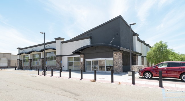

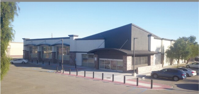

Property Detail
82935 Avenue 48
614-340-019
1.27 ACRES IN PAR 1 PM 226/047 PM 35883
Medicalbuilding
Riverside
CC
California
B and X Area of moderate flood hazard, usually the area between the limits of the 100-year and 500-year floods.
1
2024
1.27 AC
2025
Coachella Valley
049102
Inland Empire (California)
14,000 SF
Riverside-San Bernardino-Ontario, CA
NEARBY LISTINGS FOR SALE OR LEASE
DEMOGRAPHICS near 82935 Avenue 48
1 mile
3 mile
5 mile
2025 Total Population
20,701
104,199
176,444
2030 Population
21,327
107,779
184,711
Pop Growth 2025-2030
+ 3.02%
+ 3.44%
+ 4.69%
Average Age
36
37
40
2025 Total Households
5,918
30,235
57,068
HH Growth 2025-2030
+ 3.48%
+ 3.75%
+ 5.33%
Median Household Inc
$69,468
$72,752
$84,375
Avg Household Size
3.30
3.30
3.00
2025 Avg HH Vehicles
2.00
2.00
2.00
Median Home Value
$445,215
$437,159
$567,017
Median Year Built
1992
1991
1998
Nearby Places
Map Layers
Map Styles
 Street
 Aerial
Layers
 Traffic
 Biking
Places
Listings with unknown addresses are not visible on the map
- Restaurants
- Banks
- Shops
- Fitness
- Groceries
PUBLIC TRANSPORTATION
AIRPORT
Palm Springs International
Drive
Walk
Distance
Palm Springs International
31 min
23.2 mi
Freight Ports
Port of San Diego
Drive
Walk
Distance
Port of San Diego
176 min
147.4 mi
SALE & LEASE HISTORY
LISTING DATE
SALE/LEASE

Sep 23, 2016
For Sale
May 19, 2020
For Lease
Mar 15, 2019
For Sale
Mar 09, 2020
For Sale
Jul 22, 2019
For Lease
Aug 23, 2019
For Sale
Nearby Properties
Address
Land Use
TOTAL SIZE
Lot Size
Zoning
Address
Land Use
TOTAL SIZE
Lot Size
Zoning
73,832 SF
7.71 AC
Address
Land Use
TOTAL SIZE
Lot Size
Zoning
128,503 SF
6.25 AC
R3
Address
Land Use
TOTAL SIZE
Lot Size
Zoning
189,101 SF
8.98 AC
C1
Address
Land Use
TOTAL SIZE
Lot Size
Zoning
55,072 SF
6.88 AC
C2
Address
Land Use
TOTAL SIZE
Lot Size
Zoning
170,272 SF
16.28 AC
Address
Land Use
TOTAL SIZE
Lot Size
Zoning
171,910 SF
14.89 AC
C1
Address
Land Use
TOTAL SIZE
Lot Size
Zoning
52,901 SF
6 AC
Address
Land Use
TOTAL SIZE
Lot Size
Zoning
197,244 SF
20.44 AC
Address
Land Use
TOTAL SIZE
Lot Size
Zoning
55,695 SF
10.60 AC
C1
Address
Land Use
TOTAL SIZE
Lot Size
Zoning
58,560 SF
3.01 AC
Address
Land Use
TOTAL SIZE
Lot Size
Zoning
52,971 SF
7.29 AC
Address
Land Use
TOTAL SIZE
Lot Size
Zoning
2,841 SF
7.51 AC
A1
Address
Land Use
TOTAL SIZE
Lot Size
Zoning
102,400 SF
6.98 AC
Address
Land Use
TOTAL SIZE
Lot Size
Zoning
39,776 SF
4.46 AC
C2
Address
Land Use
TOTAL SIZE
Lot Size
Zoning
102,867 SF
11.10 AC
Address
Land Use
TOTAL SIZE
Lot Size
Zoning
35,760 SF
3.74 AC
Address
Land Use
TOTAL SIZE
Lot Size
Zoning
94,642 SF
10 AC
Address
Land Use
TOTAL SIZE
Lot Size
Zoning
104,741 SF
5.80 AC
R1
Address
Land Use
TOTAL SIZE
Lot Size
Zoning
48,578 SF
7.88 AC
Address
Land Use
TOTAL SIZE
Lot Size
Zoning
67,787 SF
3.93 AC
R3
Address
Land Use
TOTAL SIZE
Lot Size
Zoning
86,063 SF
4.11 AC
Address
Land Use
TOTAL SIZE
Lot Size
Zoning
114,716 SF
6.38 AC
Address
Land Use
TOTAL SIZE
Lot Size
Zoning
41,091 SF
4.65 AC
Address
Land Use
TOTAL SIZE
Lot Size
Zoning
105,122 SF
2.23 AC
Address
Land Use
TOTAL SIZE
Lot Size
Zoning
100,110 SF
4.03 AC
Address
Land Use
TOTAL SIZE
Lot Size
Zoning
86,479 SF
6.46 AC
Address
Land Use
TOTAL SIZE
Lot Size
Zoning
44,511 SF
9.40 AC
CM
Address
Land Use
TOTAL SIZE
Lot Size
Zoning
34,312 SF
3.15 AC
Address
Land Use
TOTAL SIZE
Lot Size
Zoning
84,490 SF
4.20 AC
R3
The World's #1 Commercial Real Estate Marketplace
Connect with us
© 2026 CoStar Group
The information above has been obtained from sources believed reliable. While we do not doubt its accuracy we have not verified it and make no guarantee, warranty or representation about it. It is your responsibility to independently confirm its accuracy and completeness. Any projections, opinions, assumptions, or estimates used are for example only and do not represent the current or future performance of the property. The value of this transaction to you depends on tax and other factors which should be evaluated by your tax, financial, and legal advisors. You and your advisors should conduct a careful, independent investigation of the property to determine to your satisfaction the suitability of the property for your needs.