Property Record
83 Calvert St, Harrison, NY 10528
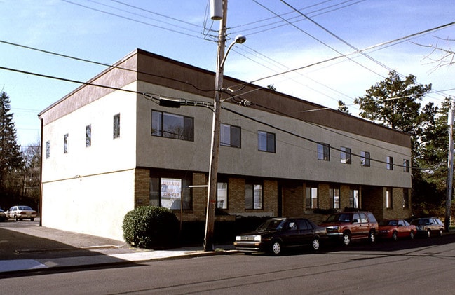

Property Detail
83 Calvert St
2801-000-121-00000-000-0008
Westchester
Officebuilding
New York
B and X Area of moderate flood hazard, usually the area between the limits of the 100-year and 500-year floods.
8
2025
0.27 AC
2025
East I-287 Corridor
008403
Westchester/So Connecticut
8,286 SF
New York-Jersey City-White Plains, NY-NJ
NEARBY LISTINGS FOR SALE OR LEASE
DEMOGRAPHICS near 83 Calvert St
1 mile
3 mile
5 mile
2025 Total Population
16,084
71,447
213,521
2030 Population
15,944
71,926
214,974
Pop Growth 2025-2030
(0.87%)
+ 0.67%
+ 0.68%
Average Age
41
41
41
2025 Total Households
5,901
24,923
73,769
HH Growth 2025-2030
(0.71%)
+ 0.73%
+ 0.72%
Median Household Inc
$140,283
$179,391
$157,798
Avg Household Size
2.70
2.80
2.80
2025 Avg HH Vehicles
2.00
2.00
2.00
Median Home Value
$820,668
$1,017,087
$902,789
Median Year Built
1957
1957
1954
Nearby Places
Map Layers
Map Styles
 Street
 Aerial
Layers
 Traffic
 Biking
Places
Listings with unknown addresses are not visible on the map
- Restaurants
- Banks
- Shops
- Fitness
- Groceries
PUBLIC TRANSPORTATION
TRANSIT/SUBWAY
Harrison Station (New Haven Line - Metro-North Commuter Railroad Company (Metro-North))
Drive
Walk
Distance
Harrison Station (New Haven Line - Metro-North Commuter Railroad Company (Metro-North))
2 min
5 min
0.3 mi
COMMUTER RAIL
Harrison Station (New Haven Line - Metro-North Commuter Railroad Company (Metro-North))
Drive
Walk
Distance
Harrison Station (New Haven Line - Metro-North Commuter Railroad Company (Metro-North))
2 min
5 min
0.3 mi
Mamaroneck Station (New Haven Line - Metro-North Commuter Railroad Company (Metro-North))
Drive
Walk
Distance
Mamaroneck Station (New Haven Line - Metro-North Commuter Railroad Company (Metro-North))
5 min
1.9 mi
AIRPORT
Westchester County
Drive
Walk
Distance
Westchester County
17 min
10.1 mi
LaGuardia
Drive
Walk
Distance
LaGuardia
37 min
20.4 mi
John F Kennedy International
Drive
Walk
Distance
John F Kennedy International
43 min
28.0 mi
Freight Ports
NY - Red Hook Container Terminal
Drive
Walk
Distance
NY - Red Hook Container Terminal
52 min
30.9 mi
Nearby Properties
Address
Land Use
TOTAL SIZE
Lot Size
Zoning
Address
Land Use
TOTAL SIZE
Lot Size
Zoning
413,946 SF
20.27 AC
Address
Land Use
TOTAL SIZE
Lot Size
Zoning
Address
Land Use
TOTAL SIZE
Lot Size
Zoning
277,172 SF
29.98 AC
CD COMM
Address
Land Use
TOTAL SIZE
Lot Size
Zoning
125,010 SF
4.02 AC
Address
Land Use
TOTAL SIZE
Lot Size
Zoning
556,297 SF
25.31 AC
05 - COMME
Address
Land Use
TOTAL SIZE
Lot Size
Zoning
5COMMUND
Address
Land Use
TOTAL SIZE
Lot Size
Zoning
21.33 AC
Address
Land Use
TOTAL SIZE
Lot Size
Zoning
118,723 SF
3.45 AC
Address
Land Use
TOTAL SIZE
Lot Size
Zoning
143,372 SF
24.05 AC
OB-2 OFFC
Address
Land Use
TOTAL SIZE
Lot Size
Zoning
84,747 SF
8.64 AC
C1-P RTAIL
Address
Land Use
TOTAL SIZE
Lot Size
Zoning
82,895 SF
23.03 AC
A2
Address
Land Use
TOTAL SIZE
Lot Size
Zoning
188.31 AC
Address
Land Use
TOTAL SIZE
Lot Size
Zoning
67.51 AC
Address
Land Use
TOTAL SIZE
Lot Size
Zoning
9.30 AC
M2 INDUST
Address
Land Use
TOTAL SIZE
Lot Size
Zoning
1,056 SF
42.50 AC
PB
Address
Land Use
TOTAL SIZE
Lot Size
Zoning
108,367 SF
5.57 AC
AA1
Address
Land Use
TOTAL SIZE
Lot Size
Zoning
48,499 SF
8.52 AC
A2/A3
Address
Land Use
TOTAL SIZE
Lot Size
Zoning
11,951 SF
24.88 AC
Address
Land Use
TOTAL SIZE
Lot Size
Zoning
132,505 SF
5.53 AC
R6
Address
Land Use
TOTAL SIZE
Lot Size
Zoning
6.31 AC
R-5 SFR
Address
Land Use
TOTAL SIZE
Lot Size
Zoning
37,187 SF
2.62 AC
Address
Land Use
TOTAL SIZE
Lot Size
Zoning
109,212 SF
1.80 AC
CD COMM
Address
Land Use
TOTAL SIZE
Lot Size
Zoning
34,454 SF
216.47 AC
Address
Land Use
TOTAL SIZE
Lot Size
Zoning
99,502 SF
11.97 AC
Address
Land Use
TOTAL SIZE
Lot Size
Zoning
48,240 SF
3.89 AC
Address
Land Use
TOTAL SIZE
Lot Size
Zoning
64,966 SF
4.92 AC
R20
Address
Land Use
TOTAL SIZE
Lot Size
Zoning
68,022 SF
4.31 AC
Address
Land Use
TOTAL SIZE
Lot Size
Zoning
76,258 SF
4.22 AC
R7.5
Address
Land Use
TOTAL SIZE
Lot Size
Zoning
62,664 SF
3.50 AC
Address
Land Use
TOTAL SIZE
Lot Size
Zoning
101,278 SF
8.07 AC
CD COMM
The World's #1 Commercial Real Estate Marketplace
Connect with us
© 2026 CoStar Group
The information above has been obtained from sources believed reliable. While we do not doubt its accuracy we have not verified it and make no guarantee, warranty or representation about it. It is your responsibility to independently confirm its accuracy and completeness. Any projections, opinions, assumptions, or estimates used are for example only and do not represent the current or future performance of the property. The value of this transaction to you depends on tax and other factors which should be evaluated by your tax, financial, and legal advisors. You and your advisors should conduct a careful, independent investigation of the property to determine to your satisfaction the suitability of the property for your needs.