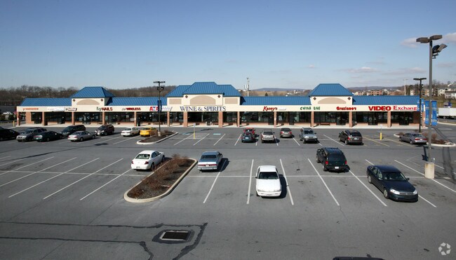
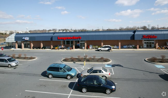
Property Record
83 Doe Run Rd, Manheim, PA 17545


Save to a Folder
{{folder.Name}}
{{folder.ListingIds.length}} Properties
{{folder.ListingIds.length}} Property
Create a New Folder
Property Detail
83 Doe Run Rd
Supermarket
LANCASTER
CC
Pennsylvania
B and X Area of moderate flood hazard, usually the area between the limits of the 100-year and 500-year floods.
11.40 AC
2025
Lancaster County
2026
Philadelphia
010502
Lancaster, PA
83,878 SF
500-04454-0-0000
NEARBY LISTINGS FOR SALE OR LEASE
-
-
View all Manheim listings for lease on LoopNet.com
DEMOGRAPHICS near 83 Doe Run Rd
1 mile
3 mile
5 mile
2025 Total Population
5,884
17,182
45,375
2030 Population
5,998
17,555
46,260
Pop Growth 2025-2030
+ 1.94%
+ 2.17%
+ 1.95%
Average Age
42
41
43
2025 Total Households
2,381
6,639
17,619
HH Growth 2025-2030
+ 2.02%
+ 2.21%
+ 2.01%
Median Household Inc
$75,240
$82,845
$90,400
Avg Household Size
2.40
2.50
2.50
2025 Avg HH Vehicles
2.00
2.00
2.00
Median Home Value
$260,905
$293,516
$325,511
Median Year Built
1960
1971
1978
Nearby Places
Map Layers
Map Styles
 Street
 Aerial
Layers
 Traffic
 Biking
Places
Listings with unknown addresses are not visible on the map
- Restaurants
- Banks
- Shops
- Fitness
- Groceries
PUBLIC TRANSPORTATION
COMMUTER RAIL
Mount Joy Amtrak (Keystone Service - Amtrak)
Drive
Walk
Distance
Mount Joy Amtrak (Keystone Service - Amtrak)
15 min
8.6 mi
AIRPORT
Harrisburg International
Drive
Walk
Distance
Harrisburg International
37 min
27.2 mi
Freight Ports
Port of Wilmington, RI
Drive
Walk
Distance
Port of Wilmington, RI
110 min
64.0 mi
SALE & LEASE HISTORY
LISTING DATE
SALE/LEASE

Sep 25, 2016
For Lease
Mar 15, 2017
For Lease
Nearby Properties
Address
Land Use
TOTAL SIZE
Lot Size
Zoning
Address
Land Use
TOTAL SIZE
Lot Size
Zoning
282,030 SF
107.20 AC
A
Address
Land Use
TOTAL SIZE
Lot Size
Zoning
398,438 SF
371.89 AC
LC
Address
Land Use
TOTAL SIZE
Lot Size
Zoning
184,800 SF
32.10 AC
R-3
Address
Land Use
TOTAL SIZE
Lot Size
Zoning
227,046 SF
24.78 AC
Address
Land Use
TOTAL SIZE
Lot Size
Zoning
195,629 SF
6 AC
Address
Land Use
TOTAL SIZE
Lot Size
Zoning
169 SF
2,253.50 AC
Address
Land Use
TOTAL SIZE
Lot Size
Zoning
234,006 SF
21.90 AC
R-1
Address
Land Use
TOTAL SIZE
Lot Size
Zoning
94,245 SF
111 AC
A
Address
Land Use
TOTAL SIZE
Lot Size
Zoning
97,541 SF
17.20 AC
CC
Address
Land Use
TOTAL SIZE
Lot Size
Zoning
67,673 SF
0.37 AC
R-3
Address
Land Use
TOTAL SIZE
Lot Size
Zoning
154,000 SF
21 AC
R-2
Address
Land Use
TOTAL SIZE
Lot Size
Zoning
56,982 SF
92.50 AC
A
Address
Land Use
TOTAL SIZE
Lot Size
Zoning
576 SF
18.21 AC
PC-1
Address
Land Use
TOTAL SIZE
Lot Size
Zoning
111,176 SF
14.80 AC
R-3
Address
Land Use
TOTAL SIZE
Lot Size
Zoning
121,697 SF
20.58 AC
Address
Land Use
TOTAL SIZE
Lot Size
Zoning
80,000 SF
7.85 AC
PC-1
Address
Land Use
TOTAL SIZE
Lot Size
Zoning
42,835 SF
2.80 AC
CC
Address
Land Use
TOTAL SIZE
Lot Size
Zoning
86,000 SF
5.57 AC
R-2
Address
Land Use
TOTAL SIZE
Lot Size
Zoning
20,970 SF
10 AC
Address
Land Use
TOTAL SIZE
Lot Size
Zoning
77,495 SF
6.85 AC
PC-1
Address
Land Use
TOTAL SIZE
Lot Size
Zoning
46,104 SF
135.30 AC
A
Address
Land Use
TOTAL SIZE
Lot Size
Zoning
2,160 SF
61.98 AC
R-2
Address
Land Use
TOTAL SIZE
Lot Size
Zoning
35,521 SF
0.94 AC
Address
Land Use
TOTAL SIZE
Lot Size
Zoning
76,079 SF
10.10 AC
I
Address
Land Use
TOTAL SIZE
Lot Size
Zoning
19,744 SF
2.38 AC
I
Address
Land Use
TOTAL SIZE
Lot Size
Zoning
2,644 SF
85.30 AC
A
Address
Land Use
TOTAL SIZE
Lot Size
Zoning
3,030 SF
7.10 AC
A
Address
Land Use
TOTAL SIZE
Lot Size
Zoning
72,800 SF
6.90 AC
I
Address
Land Use
TOTAL SIZE
Lot Size
Zoning
108,000 SF
4.64 AC
PC-1
The World's #1 Commercial Real Estate Marketplace
Connect with us
© 2026 CoStar Group
The information above has been obtained from sources believed reliable. While we do not doubt its accuracy we have not verified it and make no guarantee, warranty or representation about it. It is your responsibility to independently confirm its accuracy and completeness. Any projections, opinions, assumptions, or estimates used are for example only and do not represent the current or future performance of the property. The value of this transaction to you depends on tax and other factors which should be evaluated by your tax, financial, and legal advisors. You and your advisors should conduct a careful, independent investigation of the property to determine to your satisfaction the suitability of the property for your needs.