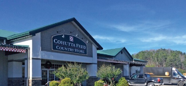
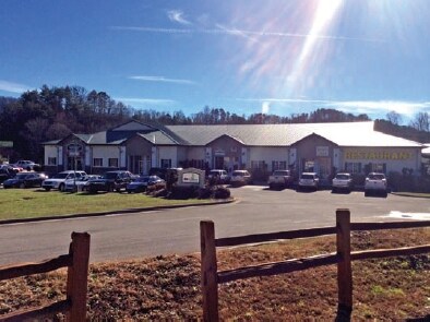
Property Record
83 Dunbarton Farm Rd, Blue Ridge, GA 30513

NEARBY LISTINGS FOR SALE OR LEASE
-
-
View all Blue Ridge listings for sale on LoopNet.com
Property Detail
83 Dunbarton Farm Rd
0054-A-06302
Comm-Davis Blvd
Storebuilding
7-2 LL9 DB1508-732* 5.12 ACS
X
Fannin
13123C0100D
Georgia
2024
9
2025
5.12 AC
050400
Georgia Northeast
21,540 SF
Other Market Areas
DEMOGRAPHICS near 83 Dunbarton Farm Rd
1 Mile
3 Mile
5 Mile
2024 Total Population
719
5,154
9,752
2029 Population
776
5,519
10,427
Pop Growth 2024-2029
+ 7.93%
+ 7.08%
+ 6.92%
Average Age
48
48
48
2024 Total Households
319
2,348
4,388
HH Growth 2024-2029
+ 7.84%
+ 7.03%
+ 6.86%
Median Household Inc
$55,624
$49,922
$51,640
Avg Household Size
2.10
2.10
2.20
2024 Avg HH Vehicles
2.00
2.00
2.00
Median Home Value
$222,000
$250,295
$276,110
Median Year Built
1995
1994
1995
Nearby Places
Map Layers
Map Styles
 Street
 Aerial
- Restaurants
- Banks
- Shops
- Fitness
- Groceries
SALE & LEASE HISTORY
LISTING DATE
SALE/LEASE

Mar 24, 2017
For Sale
Apr 13, 2017
For Sale
Nearby Properties
Address
Land Use
TOTAL SIZE
Lot Size
Zoning
Address
Land Use
TOTAL SIZE
Lot Size
Zoning
13,799 SF
0.89 AC
COMMERCIAL
Address
Land Use
TOTAL SIZE
Lot Size
Zoning
62,876 SF
21 AC
RESIDENTIA
Address
Land Use
TOTAL SIZE
Lot Size
Zoning
121,005 SF
14.93 AC
COMMERCIAL
Address
Land Use
TOTAL SIZE
Lot Size
Zoning
299 SF
14.06 AC
COMMERCIAL
Address
Land Use
TOTAL SIZE
Lot Size
Zoning
42,914 SF
0.74 AC
RESIDENTIA
Address
Land Use
TOTAL SIZE
Lot Size
Zoning
78,560 SF
5.60 AC
COMMERCIAL
Address
Land Use
TOTAL SIZE
Lot Size
Zoning
104,347 SF
9.63 AC
Address
Land Use
TOTAL SIZE
Lot Size
Zoning
60,810 SF
0.95 AC
EXEMPT
Address
Land Use
TOTAL SIZE
Lot Size
Zoning
63,095 SF
9.73 AC
03
Address
Land Use
TOTAL SIZE
Lot Size
Zoning
17,871 SF
4.82 AC
RESIDENTIA
Address
Land Use
TOTAL SIZE
Lot Size
Zoning
45,342 SF
2.02 AC
COMMERCIAL
Address
Land Use
TOTAL SIZE
Lot Size
Zoning
47,916 SF
7.93 AC
INDUSTRIAL
Address
Land Use
TOTAL SIZE
Lot Size
Zoning
0.66 AC
RESIDENTIA
Address
Land Use
TOTAL SIZE
Lot Size
Zoning
13,936 SF
38.25 AC
COMMERCIAL
Address
Land Use
TOTAL SIZE
Lot Size
Zoning
22,900 SF
3.23 AC
COMMERCIAL
Address
Land Use
TOTAL SIZE
Lot Size
Zoning
12,992 SF
9.10 AC
COMMERCIAL
Address
Land Use
TOTAL SIZE
Lot Size
Zoning
30,279 SF
7 AC
COMMERCIAL
Address
Land Use
TOTAL SIZE
Lot Size
Zoning
63,000 SF
3 AC
RESIDENTIA
Address
Land Use
TOTAL SIZE
Lot Size
Zoning
12.80 AC
COMMERCIAL
Address
Land Use
TOTAL SIZE
Lot Size
Zoning
31,885 SF
0.37 AC
COMMERCIAL
Address
Land Use
TOTAL SIZE
Lot Size
Zoning
7,456 SF
3.60 AC
RESIDENTIA
Address
Land Use
TOTAL SIZE
Lot Size
Zoning
9,600 SF
6.34 AC
COMMERCIAL
Address
Land Use
TOTAL SIZE
Lot Size
Zoning
19,980 SF
1.90 AC
RESIDENTIA
Address
Land Use
TOTAL SIZE
Lot Size
Zoning
17,660 SF
2.70 AC
RESIDENTIA
Address
Land Use
TOTAL SIZE
Lot Size
Zoning
23,182 SF
3.44 AC
COMMERCIAL
Address
Land Use
TOTAL SIZE
Lot Size
Zoning
25.95 AC
COMMERCIAL
Address
Land Use
TOTAL SIZE
Lot Size
Zoning
15,440 SF
14.55 AC
EXEMPT
Address
Land Use
TOTAL SIZE
Lot Size
Zoning
7,000 SF
23.06 AC
RESIDENTIA
Address
Land Use
TOTAL SIZE
Lot Size
Zoning
1,400 SF
16.54 AC
COMMERCIAL
The World's #1 Commercial Real Estate Marketplace
Connect with us
© 2026 CoStar Group
The information above has been obtained from sources believed reliable. While we do not doubt its accuracy we have not verified it and make no guarantee, warranty or representation about it. It is your responsibility to independently confirm its accuracy and completeness. Any projections, opinions, assumptions, or estimates used are for example only and do not represent the current or future performance of the property. The value of this transaction to you depends on tax and other factors which should be evaluated by your tax, financial, and legal advisors. You and your advisors should conduct a careful, independent investigation of the property to determine to your satisfaction the suitability of the property for your needs.