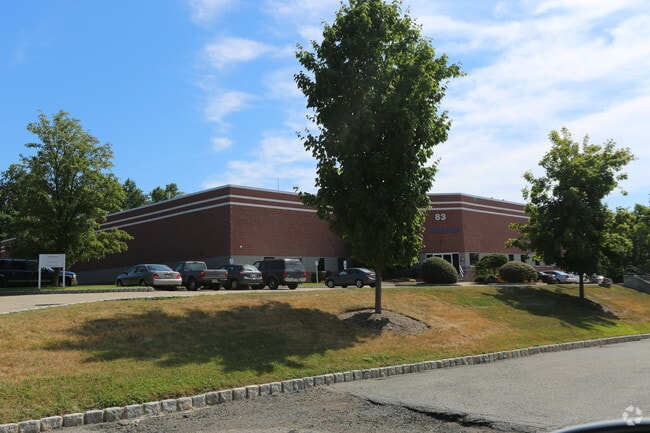
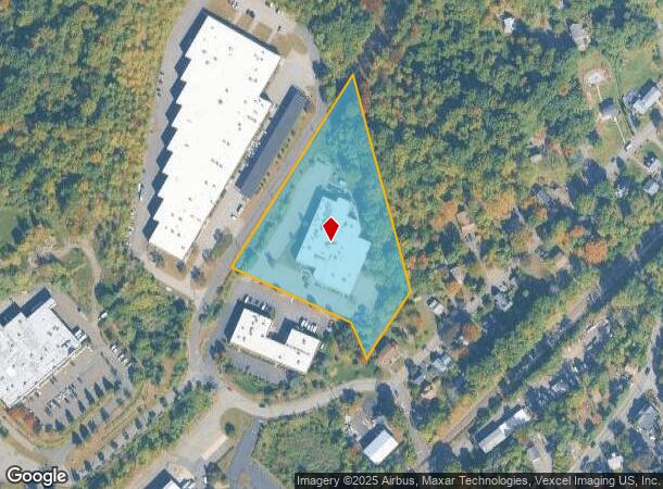
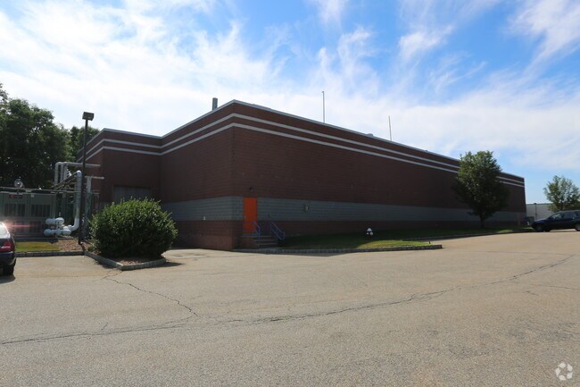
Property Record
83 Fulton St, Boonton, NJ 07005
NEARBY LISTINGS FOR SALE OR LEASE
Property Detail
83 Fulton St
Newark, NJ-PA
Morris
01-00069-0000-00073-05
New Jersey
Industrialgeneral
73.5
2024
3.53 AC
2025
Eastern Morris
041000
Northern New Jersey
32,094 SF
DEMOGRAPHICS near 83 Fulton St
1 Mile
3 Mile
5 Mile
2024 Total Population
7,080
41,680
101,497
2029 Population
7,119
41,486
101,612
Pop Growth 2024-2029
+ 0.55%
(0.47%)
+ 0.11%
Average Age
43
42
43
2024 Total Households
2,763
15,145
37,485
HH Growth 2024-2029
+ 0.76%
(0.55%)
+ 0.20%
Median Household Inc
$105,618
$118,948
$117,567
Avg Household Size
2.50
2.70
2.60
2024 Avg HH Vehicles
2.00
2.00
2.00
Median Home Value
$541,971
$580,954
$560,024
Median Year Built
1970
1967
1968
Nearby Places
Map Layers
Map Styles
 Street
 Aerial
- Restaurants
- Banks
- Shops
- Fitness
- Groceries
PUBLIC TRANSPORTATION
COMMUTER RAIL
Boonton (Montclair-Boonton Line - NJ Transit Commuter Rail (NJ Transit))
DRIVE
WALK
Distance
Boonton (Montclair-Boonton Line - NJ Transit Commuter Rail (NJ Transit))
3 min
1.1 mi
Towaco (Montclair-Boonton Line - NJ Transit Commuter Rail (NJ Transit))
DRIVE
WALK
Distance
Towaco (Montclair-Boonton Line - NJ Transit Commuter Rail (NJ Transit))
7 min
3.3 mi
AIRPORT
Newark Liberty International
DRIVE
WALK
Distance
Newark Liberty International
38 min
28.9 mi
LaGuardia
DRIVE
WALK
Distance
LaGuardia
56 min
38.5 mi
Freight Ports
Maher Terminal
DRIVE
WALK
Distance
Maher Terminal
41 min
29.4 mi
Nearby Properties
Address
Land Use
TOTAL SIZE
Lot Size
Zoning
Address
Land Use
TOTAL SIZE
Lot Size
Zoning
98,228 SF
16.66 AC
I-1
Address
Land Use
TOTAL SIZE
Lot Size
Zoning
140,560 SF
49.81 AC
R27A
Address
Land Use
TOTAL SIZE
Lot Size
Zoning
4,172 SF
338 AC
R-1
Address
Land Use
TOTAL SIZE
Lot Size
Zoning
132,411 SF
24.87 AC
B-5
Address
Land Use
TOTAL SIZE
Lot Size
Zoning
4.99 AC
OB
Address
Land Use
TOTAL SIZE
Lot Size
Zoning
4.02 AC
R-3
Address
Land Use
TOTAL SIZE
Lot Size
Zoning
Address
Land Use
TOTAL SIZE
Lot Size
Zoning
41.21 AC
R-A
Address
Land Use
TOTAL SIZE
Lot Size
Zoning
10 AC
RASH
Address
Land Use
TOTAL SIZE
Lot Size
Zoning
50,948 SF
5.60 AC
C-1
Address
Land Use
TOTAL SIZE
Lot Size
Zoning
77,992 SF
9.87 AC
OB1
Address
Land Use
TOTAL SIZE
Lot Size
Zoning
18.05 AC
OB
Address
Land Use
TOTAL SIZE
Lot Size
Zoning
44,390 SF
2.06 AC
I-2
Address
Land Use
TOTAL SIZE
Lot Size
Zoning
88,819 SF
80.33 AC
R-1A
Address
Land Use
TOTAL SIZE
Lot Size
Zoning
76,160 SF
12.83 AC
I2
Address
Land Use
TOTAL SIZE
Lot Size
Zoning
1,227 SF
1,116.14 AC
R-3
Address
Land Use
TOTAL SIZE
Lot Size
Zoning
39,470 SF
4.65 AC
B-3
Address
Land Use
TOTAL SIZE
Lot Size
Zoning
114,540 SF
2.57 AC
OB2B
Address
Land Use
TOTAL SIZE
Lot Size
Zoning
25,266 SF
20.40 AC
R27A
Address
Land Use
TOTAL SIZE
Lot Size
Zoning
14.58 AC
R-30
Address
Land Use
TOTAL SIZE
Lot Size
Zoning
4,948 SF
11.23 AC
R-40
Address
Land Use
TOTAL SIZE
Lot Size
Zoning
122,022 SF
19.09 AC
R-2A
Address
Land Use
TOTAL SIZE
Lot Size
Zoning
2.22 AC
OB-2
Address
Land Use
TOTAL SIZE
Lot Size
Zoning
12.66 AC
R-A
Address
Land Use
TOTAL SIZE
Lot Size
Zoning
7.70 AC
R-A
Address
Land Use
TOTAL SIZE
Lot Size
Zoning
12.58 AC
R-A
Address
Land Use
TOTAL SIZE
Lot Size
Zoning
91,880 SF
24.54 AC
I2
Address
Land Use
TOTAL SIZE
Lot Size
Zoning
18,352 SF
4.19 AC
OB2A
Address
Land Use
TOTAL SIZE
Lot Size
Zoning
9.90 AC
R43
Address
Land Use
TOTAL SIZE
Lot Size
Zoning
4,272 SF
212.93 AC
R-1B
The World's #1 Commercial Real Estate Marketplace
Connect with us
© 2025 CoStar Group
The information above has been obtained from sources believed reliable. While we do not doubt its accuracy we have not verified it and make no guarantee, warranty or representation about it. It is your responsibility to independently confirm its accuracy and completeness. Any projections, opinions, assumptions, or estimates used are for example only and do not represent the current or future performance of the property. The value of this transaction to you depends on tax and other factors which should be evaluated by your tax, financial, and legal advisors. You and your advisors should conduct a careful, independent investigation of the property to determine to your satisfaction the suitability of the property for your needs.