Property Record
83 Hampton Pl, Freeport, NY 11520
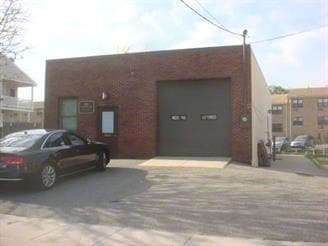

Property Detail
83 Hampton Pl
Nassau County-Suffolk County, NY
TOWN #1 SCH DIST 009
2009-54-323-00-0054-0
Nassau
Commercialnec
New York
AE The base floodplain where base flood elevations are provided. AE Zones are now used on new format FIRMs instead of A1-A30 Zones.
54
2025
0.08 AC
2025
Southern Nassau
414501
Long Island (New York)
1,680 SF
NEARBY LISTINGS FOR SALE OR LEASE
DEMOGRAPHICS near 83 Hampton Pl
1 mile
3 mile
5 mile
2025 Total Population
24,854
145,610
375,804
2030 Population
24,981
145,537
375,260
Pop Growth 2025-2030
+ 0.51%
(0.05%)
(0.14%)
Average Age
42
41
41
2025 Total Households
8,224
46,712
121,753
HH Growth 2025-2030
+ 0.44%
(0.05%)
(0.17%)
Median Household Inc
$133,024
$137,274
$134,663
Avg Household Size
2.90
3.00
2.90
2025 Avg HH Vehicles
2.00
2.00
2.00
Median Home Value
$623,661
$670,789
$682,041
Median Year Built
1955
1952
1953
Nearby Places
Map Layers
Map Styles
 Street
 Aerial
Layers
 Traffic
 Biking
Places
Listings with unknown addresses are not visible on the map
- Restaurants
- Banks
- Shops
- Fitness
- Groceries
PUBLIC TRANSPORTATION
COMMUTER RAIL
Freeport Station (Babylon Branch - Long Island Rail Road)
Drive
Walk
Distance
Freeport Station (Babylon Branch - Long Island Rail Road)
6 min
2.2 mi
Baldwin Station (Babylon Branch - Long Island Rail Road)
Drive
Walk
Distance
Baldwin Station (Babylon Branch - Long Island Rail Road)
6 min
2.3 mi
AIRPORT
John F Kennedy International
Drive
Walk
Distance
John F Kennedy International
23 min
13.9 mi
LaGuardia
Drive
Walk
Distance
LaGuardia
34 min
21.4 mi
Long Island MacArthur
Drive
Walk
Distance
Long Island MacArthur
48 min
31.8 mi
Freight Ports
NY - Red Hook Container Terminal
Drive
Walk
Distance
NY - Red Hook Container Terminal
45 min
25.6 mi
SALE & LEASE HISTORY
LISTING DATE
SALE/LEASE

Mar 17, 2025
For Sale
Nearby Properties
Address
Land Use
TOTAL SIZE
Lot Size
Zoning
Address
Land Use
TOTAL SIZE
Lot Size
Zoning
Address
Land Use
TOTAL SIZE
Lot Size
Zoning
5,800 SF
10.48 AC
Address
Land Use
TOTAL SIZE
Lot Size
Zoning
986.74 AC
Address
Land Use
TOTAL SIZE
Lot Size
Zoning
457.91 AC
Address
Land Use
TOTAL SIZE
Lot Size
Zoning
169.25 AC
Address
Land Use
TOTAL SIZE
Lot Size
Zoning
336,450 SF
139.91 AC
Address
Land Use
TOTAL SIZE
Lot Size
Zoning
133.85 AC
Address
Land Use
TOTAL SIZE
Lot Size
Zoning
57,970 SF
1.69 AC
Address
Land Use
TOTAL SIZE
Lot Size
Zoning
80.84 AC
Address
Land Use
TOTAL SIZE
Lot Size
Zoning
65,235 SF
15.48 AC
Address
Land Use
TOTAL SIZE
Lot Size
Zoning
94,204 SF
35.42 AC
Address
Land Use
TOTAL SIZE
Lot Size
Zoning
116.80 AC
Address
Land Use
TOTAL SIZE
Lot Size
Zoning
140,000 SF
50.78 AC
Address
Land Use
TOTAL SIZE
Lot Size
Zoning
151,757 SF
34.38 AC
Address
Land Use
TOTAL SIZE
Lot Size
Zoning
80,895 SF
26.22 AC
Address
Land Use
TOTAL SIZE
Lot Size
Zoning
99,904 SF
20.17 AC
Address
Land Use
TOTAL SIZE
Lot Size
Zoning
20,670 SF
6.62 AC
Address
Land Use
TOTAL SIZE
Lot Size
Zoning
357,868 SF
24.92 AC
Address
Land Use
TOTAL SIZE
Lot Size
Zoning
377,041 SF
14.43 AC
Address
Land Use
TOTAL SIZE
Lot Size
Zoning
140,992 SF
12.07 AC
Address
Land Use
TOTAL SIZE
Lot Size
Zoning
61.52 AC
Address
Land Use
TOTAL SIZE
Lot Size
Zoning
61.52 AC
Address
Land Use
TOTAL SIZE
Lot Size
Zoning
58.86 AC
Address
Land Use
TOTAL SIZE
Lot Size
Zoning
59,715 SF
12.81 AC
Address
Land Use
TOTAL SIZE
Lot Size
Zoning
82,698 SF
12.03 AC
Address
Land Use
TOTAL SIZE
Lot Size
Zoning
290,400 SF
246.92 AC
Address
Land Use
TOTAL SIZE
Lot Size
Zoning
41,612 SF
3.89 AC
Address
Land Use
TOTAL SIZE
Lot Size
Zoning
37.90 AC
Address
Land Use
TOTAL SIZE
Lot Size
Zoning
278,714 SF
3.04 AC
Address
Land Use
TOTAL SIZE
Lot Size
Zoning
193,285 SF
9.64 AC
The World's #1 Commercial Real Estate Marketplace
Connect with us
© 2026 CoStar Group
The information above has been obtained from sources believed reliable. While we do not doubt its accuracy we have not verified it and make no guarantee, warranty or representation about it. It is your responsibility to independently confirm its accuracy and completeness. Any projections, opinions, assumptions, or estimates used are for example only and do not represent the current or future performance of the property. The value of this transaction to you depends on tax and other factors which should be evaluated by your tax, financial, and legal advisors. You and your advisors should conduct a careful, independent investigation of the property to determine to your satisfaction the suitability of the property for your needs.