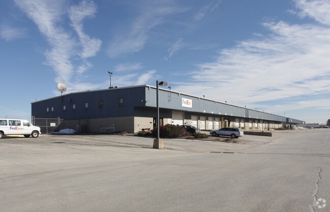
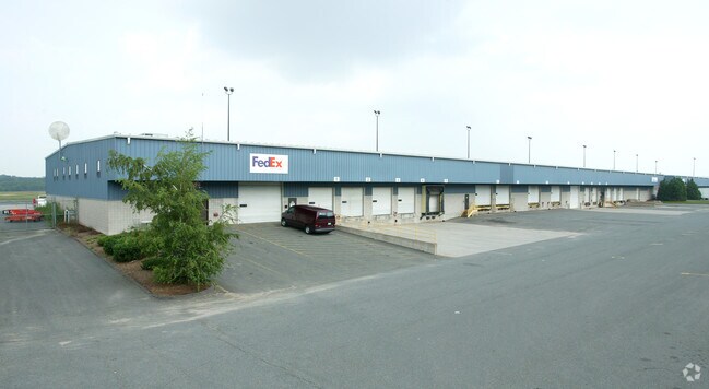
Property Record
83 Maskel Rd, South Windsor, CT 06074


Property Detail
83 Maskel Rd
Taxexempt
Hartford
CP
Connecticut
B and X Area of moderate flood hazard, usually the area between the limits of the 100-year and 500-year floods.
East Granby
0
Hartford
2025
Hartford-West Hartford-East Hartford, CT
470100
EGRA-000023-000000-000010-A000000
49,000 SF
NEARBY LISTINGS FOR SALE OR LEASE
DEMOGRAPHICS near 83 Maskel Rd
1 mile
3 mile
5 mile
2025 Total Population
138
13,155
42,649
2030 Population
141
13,421
43,703
Pop Growth 2025-2030
+ 2.17%
+ 2.02%
+ 2.47%
Average Age
43
44
44
2025 Total Households
55
5,435
17,600
HH Growth 2025-2030
+ 1.82%
+ 2.02%
+ 2.45%
Median Household Inc
$99,106
$101,851
$102,499
Avg Household Size
2.60
2.40
2.30
2025 Avg HH Vehicles
3.00
2.00
2.00
Median Home Value
$346,875
$307,315
$332,725
Median Year Built
1995
1968
1973
Nearby Places
Map Layers
Map Styles
 Street
 Aerial
Layers
 Traffic
 Biking
Places
Listings with unknown addresses are not visible on the map
- Restaurants
- Banks
- Shops
- Fitness
- Groceries
PUBLIC TRANSPORTATION
AIRPORT
Bradley International
Drive
Walk
Distance
Bradley International
36 min
16.4 mi
Freight Ports
Port of New Haven
Drive
Walk
Distance
Port of New Haven
70 min
49.4 mi
SALE & LEASE HISTORY
LISTING DATE
SALE/LEASE

Sep 25, 2016
For Lease
Nearby Properties
Address
Land Use
TOTAL SIZE
Lot Size
Zoning
Address
Land Use
TOTAL SIZE
Lot Size
Zoning
75.65 AC
PDZ GE
Address
Land Use
TOTAL SIZE
Lot Size
Zoning
3,200 SF
31.39 AC
INDUST
Address
Land Use
TOTAL SIZE
Lot Size
Zoning
29.87 AC
PDZ GE
Address
Land Use
TOTAL SIZE
Lot Size
Zoning
248,364 SF
47.28 AC
A20
Address
Land Use
TOTAL SIZE
Lot Size
Zoning
52.04 AC
MF
Address
Land Use
TOTAL SIZE
Lot Size
Zoning
40 AC
MF
Address
Land Use
TOTAL SIZE
Lot Size
Zoning
659,693 SF
102.30 AC
I
Address
Land Use
TOTAL SIZE
Lot Size
Zoning
301,011 SF
60.83 AC
I
Address
Land Use
TOTAL SIZE
Lot Size
Zoning
149,322 SF
16.76 AC
A30
Address
Land Use
TOTAL SIZE
Lot Size
Zoning
33.41 AC
MF
Address
Land Use
TOTAL SIZE
Lot Size
Zoning
156,929 SF
43 AC
GD
Address
Land Use
TOTAL SIZE
Lot Size
Zoning
85,470 SF
14.11 AC
R
Address
Land Use
TOTAL SIZE
Lot Size
Zoning
43,394 SF
35 AC
A30
Address
Land Use
TOTAL SIZE
Lot Size
Zoning
27.05 AC
COMMER
Address
Land Use
TOTAL SIZE
Lot Size
Zoning
81,412 SF
9.20 AC
GD
Address
Land Use
TOTAL SIZE
Lot Size
Zoning
66,762 SF
17.06 AC
A20
Address
Land Use
TOTAL SIZE
Lot Size
Zoning
69,939 SF
4.62 AC
GD
Address
Land Use
TOTAL SIZE
Lot Size
Zoning
168,000 SF
13.86 AC
I
Address
Land Use
TOTAL SIZE
Lot Size
Zoning
31.50 AC
PRD
Address
Land Use
TOTAL SIZE
Lot Size
Zoning
42,313 SF
5.07 AC
GD
Address
Land Use
TOTAL SIZE
Lot Size
Zoning
59,882 SF
6 AC
RC
Address
Land Use
TOTAL SIZE
Lot Size
Zoning
45,666 SF
15.33 AC
RR
Address
Land Use
TOTAL SIZE
Lot Size
Zoning
76,907 SF
6.97 AC
RC
Address
Land Use
TOTAL SIZE
Lot Size
Zoning
238.11 AC
GD
Address
Land Use
TOTAL SIZE
Lot Size
Zoning
13.39 AC
RR
Address
Land Use
TOTAL SIZE
Lot Size
Zoning
44,363 SF
23 AC
A20
Address
Land Use
TOTAL SIZE
Lot Size
Zoning
14.80 AC
PRD
Address
Land Use
TOTAL SIZE
Lot Size
Zoning
3,666 SF
63.81 AC
R-20
Address
Land Use
TOTAL SIZE
Lot Size
Zoning
1,751 SF
10.20 AC
AA30
Address
Land Use
TOTAL SIZE
Lot Size
Zoning
46,760 SF
19.57 AC
A30
The World's #1 Commercial Real Estate Marketplace
Connect with us
© 2026 CoStar Group
The information above has been obtained from sources believed reliable. While we do not doubt its accuracy we have not verified it and make no guarantee, warranty or representation about it. It is your responsibility to independently confirm its accuracy and completeness. Any projections, opinions, assumptions, or estimates used are for example only and do not represent the current or future performance of the property. The value of this transaction to you depends on tax and other factors which should be evaluated by your tax, financial, and legal advisors. You and your advisors should conduct a careful, independent investigation of the property to determine to your satisfaction the suitability of the property for your needs.