Property Record
83 N Washington Ave, Bergenfield, NJ 07621
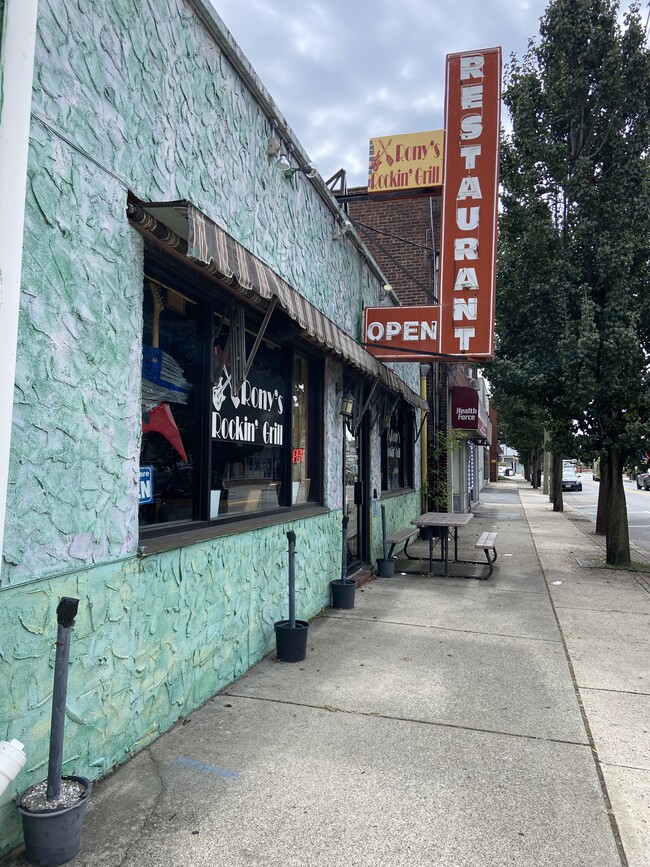

This Property Is For Sale
Property Detail
83 N Washington Ave
New York-Jersey City-White Plains, NY-NJ
50X135
03-00149-0000-00013
BERGEN
Commercialnec
New Jersey
B2
13
B and X Area of moderate flood hazard, usually the area between the limits of the 100-year and 500-year floods.
0.16 AC
2024
Palisades
2025
Northern New Jersey
003200
NEARBY LISTINGS FOR SALE OR LEASE
DEMOGRAPHICS near 83 N Washington Ave
1 mile
3 mile
5 mile
2025 Total Population
30,326
169,218
383,846
2030 Population
31,006
174,968
397,066
Pop Growth 2025-2030
+ 2.24%
+ 3.40%
+ 3.44%
Average Age
42
41
42
2025 Total Households
10,158
57,445
137,711
HH Growth 2025-2030
+ 2.24%
+ 3.45%
+ 3.50%
Median Household Inc
$126,574
$130,218
$116,963
Avg Household Size
2.90
2.90
2.70
2025 Avg HH Vehicles
2.00
2.00
2.00
Median Home Value
$482,371
$657,014
$639,669
Median Year Built
1953
1954
1957
Nearby Places
Map Layers
Map Styles
 Street
 Aerial
Layers
 Traffic
 Biking
Places
Listings with unknown addresses are not visible on the map
- Restaurants
- Banks
- Shops
- Fitness
- Groceries
PUBLIC TRANSPORTATION
COMMUTER RAIL
River Edge (Pascack Valley Line - NJ Transit Commuter Rail (NJ Transit))
Drive
Walk
Distance
River Edge (Pascack Valley Line - NJ Transit Commuter Rail (NJ Transit))
4 min
2.4 mi
Oradell (Pascack Valley Line - NJ Transit Commuter Rail (NJ Transit))
Drive
Walk
Distance
Oradell (Pascack Valley Line - NJ Transit Commuter Rail (NJ Transit))
6 min
3.5 mi
AIRPORT
LaGuardia
Drive
Walk
Distance
LaGuardia
29 min
17.7 mi
Newark Liberty International
Drive
Walk
Distance
Newark Liberty International
24 min
20.3 mi
Westchester County
Drive
Walk
Distance
Westchester County
45 min
30.2 mi
Freight Ports
NY - Red Hook Container Terminal
Drive
Walk
Distance
NY - Red Hook Container Terminal
38 min
22.5 mi
Nearby Properties
Address
Land Use
TOTAL SIZE
Lot Size
Zoning
Address
Land Use
TOTAL SIZE
Lot Size
Zoning
1,267 SF
0.14 AC
BML
Address
Land Use
TOTAL SIZE
Lot Size
Zoning
512,862 SF
14.16 AC
Address
Land Use
TOTAL SIZE
Lot Size
Zoning
572,137 SF
14.11 AC
R-D
Address
Land Use
TOTAL SIZE
Lot Size
Zoning
25,620 SF
21.37 AC
Address
Land Use
TOTAL SIZE
Lot Size
Zoning
5.22 AC
APT
Address
Land Use
TOTAL SIZE
Lot Size
Zoning
4.54 AC
R-M3
Address
Land Use
TOTAL SIZE
Lot Size
Zoning
303,434 SF
13.34 AC
Address
Land Use
TOTAL SIZE
Lot Size
Zoning
Address
Land Use
TOTAL SIZE
Lot Size
Zoning
185,878 SF
33.44 AC
B
Address
Land Use
TOTAL SIZE
Lot Size
Zoning
Address
Land Use
TOTAL SIZE
Lot Size
Zoning
65,087 SF
4 AC
Address
Land Use
TOTAL SIZE
Lot Size
Zoning
343,036 SF
8.50 AC
Address
Land Use
TOTAL SIZE
Lot Size
Zoning
Address
Land Use
TOTAL SIZE
Lot Size
Zoning
1.12 AC
Address
Land Use
TOTAL SIZE
Lot Size
Zoning
47,623 SF
88.60 AC
B
Address
Land Use
TOTAL SIZE
Lot Size
Zoning
68,824 SF
34.75 AC
R-D
Address
Land Use
TOTAL SIZE
Lot Size
Zoning
7.34 AC
Address
Land Use
TOTAL SIZE
Lot Size
Zoning
16.76 AC
R3
Address
Land Use
TOTAL SIZE
Lot Size
Zoning
169,514 SF
22.40 AC
Address
Land Use
TOTAL SIZE
Lot Size
Zoning
163.19 AC
Address
Land Use
TOTAL SIZE
Lot Size
Zoning
173,890 SF
23.80 AC
O
Address
Land Use
TOTAL SIZE
Lot Size
Zoning
21,250 SF
2.37 AC
SBD
Address
Land Use
TOTAL SIZE
Lot Size
Zoning
36.90 AC
MU
Address
Land Use
TOTAL SIZE
Lot Size
Zoning
254,512 SF
3.29 AC
HRO
Address
Land Use
TOTAL SIZE
Lot Size
Zoning
12.31 AC
R3
Address
Land Use
TOTAL SIZE
Lot Size
Zoning
1.78 AC
L1
Address
Land Use
TOTAL SIZE
Lot Size
Zoning
13.15 AC
P
Address
Land Use
TOTAL SIZE
Lot Size
Zoning
4,000 SF
27.90 AC
B3
Address
Land Use
TOTAL SIZE
Lot Size
Zoning
28 AC
U
Address
Land Use
TOTAL SIZE
Lot Size
Zoning
The World's #1 Commercial Real Estate Marketplace
Connect with us
© 2026 CoStar Group
The information above has been obtained from sources believed reliable. While we do not doubt its accuracy we have not verified it and make no guarantee, warranty or representation about it. It is your responsibility to independently confirm its accuracy and completeness. Any projections, opinions, assumptions, or estimates used are for example only and do not represent the current or future performance of the property. The value of this transaction to you depends on tax and other factors which should be evaluated by your tax, financial, and legal advisors. You and your advisors should conduct a careful, independent investigation of the property to determine to your satisfaction the suitability of the property for your needs.