Property Record
83 Nh Route 4A, Lebanon, NH 03766
This Property Is For Sale
NEARBY LISTINGS FOR SALE OR LEASE
Property Detail
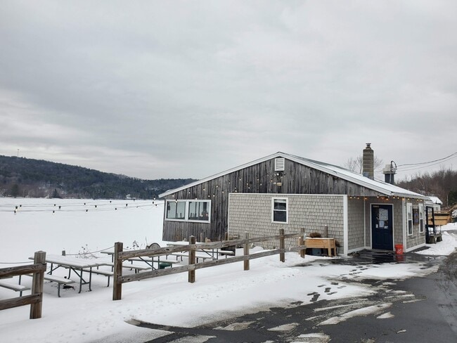
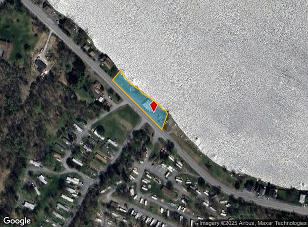
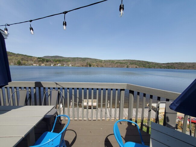
83 Nh Route 4A
Restaurantbuilding
Grafton
X
New Hampshire
33009C0919E
0.41 AC
2024
Concord/New Hampshire North Area
2024
Other Market Areas
961801
Claremont-Lebanon, NH-VT
1,080 SF
LBAN-000098-000007
DEMOGRAPHICS near 83 Nh Route 4A
1 Mile
3 Mile
5 Mile
2024 Total Population
884
4,324
15,585
2029 Population
931
4,504
16,432
Pop Growth 2024-2029
+ 5.32%
+ 4.16%
+ 5.43%
Average Age
45
45
43
2024 Total Households
386
1,943
7,298
HH Growth 2024-2029
+ 5.18%
+ 3.86%
+ 5.39%
Median Household Inc
$134,375
$103,476
$99,514
Avg Household Size
2.20
2.10
2.10
2024 Avg HH Vehicles
2.00
2.00
2.00
Median Home Value
$363,461
$316,262
$311,968
Median Year Built
1982
1977
1981
Nearby Places
- Restaurants
- Banks
- Shops
- Fitness
- Groceries
PUBLIC TRANSPORTATION
COMMUTER RAIL
White River Junction Amtrak Station (Vermonter - Amtrak)
DRIVE
WALK
Distance
White River Junction Amtrak Station (Vermonter - Amtrak)
17 min
9.4 mi
Freight Ports
Portland, ME
DRIVE
WALK
Distance
Portland, ME
195 min
163.1 mi
Nearby Properties
Address
Land Use
TOTAL SIZE
Lot Size
Zoning
Address
Land Use
TOTAL SIZE
Lot Size
Zoning
106,069 SF
19.42 AC
R3
Address
Land Use
TOTAL SIZE
Lot Size
Zoning
21.75 AC
R3
Address
Land Use
TOTAL SIZE
Lot Size
Zoning
5,560 SF
319.10 AC
C/I -
Address
Land Use
TOTAL SIZE
Lot Size
Zoning
8,628 SF
29.78 AC
R5 - R
Address
Land Use
TOTAL SIZE
Lot Size
Zoning
13,366 SF
3.60 AC
RL1
Address
Land Use
TOTAL SIZE
Lot Size
Zoning
9,400 SF
2.41 AC
RT4 -
Address
Land Use
TOTAL SIZE
Lot Size
Zoning
23,840 SF
3.59 AC
CB - W
Address
Land Use
TOTAL SIZE
Lot Size
Zoning
7,832 SF
3.92 AC
CB - W
Address
Land Use
TOTAL SIZE
Lot Size
Zoning
11,950 SF
4.03 AC
C/I -
Address
Land Use
TOTAL SIZE
Lot Size
Zoning
40,000 SF
6 AC
GC
Address
Land Use
TOTAL SIZE
Lot Size
Zoning
3.20 AC
GC
Address
Land Use
TOTAL SIZE
Lot Size
Zoning
23,152 SF
8.91 AC
INDL
Address
Land Use
TOTAL SIZE
Lot Size
Zoning
24,224 SF
4.42 AC
R1 W/O
Address
Land Use
TOTAL SIZE
Lot Size
Zoning
1,199 SF
23.60 AC
R1 W/O
Address
Land Use
TOTAL SIZE
Lot Size
Zoning
3,450 SF
4.50 AC
C/I -
Address
Land Use
TOTAL SIZE
Lot Size
Zoning
13,789 SF
4.30 AC
R1 W/O
Address
Land Use
TOTAL SIZE
Lot Size
Zoning
3,652 SF
2.85 AC
CB - W
Address
Land Use
TOTAL SIZE
Lot Size
Zoning
6,552 SF
6 AC
CB - W
Address
Land Use
TOTAL SIZE
Lot Size
Zoning
6,240 SF
27 AC
R1 W/O
Address
Land Use
TOTAL SIZE
Lot Size
Zoning
1,720 SF
2.43 AC
CB - W
Address
Land Use
TOTAL SIZE
Lot Size
Zoning
4,400 SF
2.74 AC
CB - W
Address
Land Use
TOTAL SIZE
Lot Size
Zoning
3,120 SF
7.68 AC
C/I -
Address
Land Use
TOTAL SIZE
Lot Size
Zoning
1,136 SF
0.46 AC
CB W/O
Address
Land Use
TOTAL SIZE
Lot Size
Zoning
1,836 SF
5.10 AC
C/I -
Address
Land Use
TOTAL SIZE
Lot Size
Zoning
217 AC
RL2
Address
Land Use
TOTAL SIZE
Lot Size
Zoning
1,696 SF
2.72 AC
R1 W/O
Address
Land Use
TOTAL SIZE
Lot Size
Zoning
19,784 SF
2.06 AC
RT4 -
Address
Land Use
TOTAL SIZE
Lot Size
Zoning
2,352 SF
7.79 AC
RT4 -
Address
Land Use
TOTAL SIZE
Lot Size
Zoning
1,458 SF
7.20 AC
C/I -
Address
Land Use
TOTAL SIZE
Lot Size
Zoning
8,177 SF
1.91 AC
RT4 -
The World's #1 Commercial Real Estate Marketplace
Connect with us
© 2025 CoStar Group
The information above has been obtained from sources believed reliable. While we do not doubt its accuracy we have not verified it and make no guarantee, warranty or representation about it. It is your responsibility to independently confirm its accuracy and completeness. Any projections, opinions, assumptions, or estimates used are for example only and do not represent the current or future performance of the property. The value of this transaction to you depends on tax and other factors which should be evaluated by your tax, financial, and legal advisors. You and your advisors should conduct a careful, independent investigation of the property to determine to your satisfaction the suitability of the property for your needs.