Property Record
830 Plantation Way, Montgomery, AL 36117
This Property Is For Sale
NEARBY LISTINGS FOR SALE OR LEASE
Property Detail
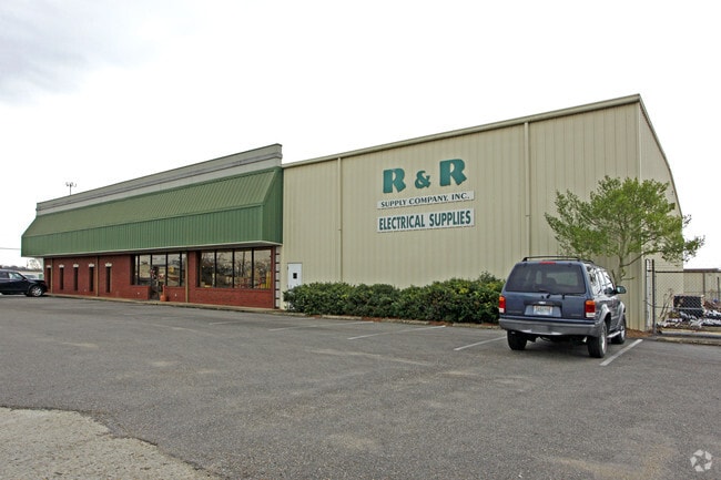
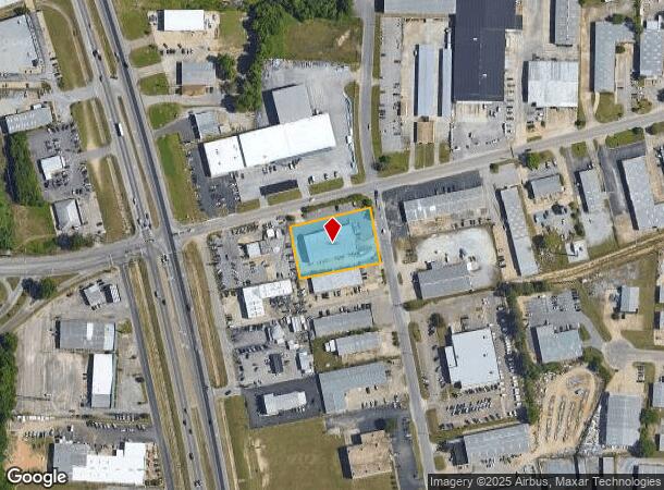
830 Plantation Way
Montgomery, AL
Todd Industrial 5
10-01-01-1-001-012.001
1001011001012001
Publicstorage
Montgomery
X
Alabama
01101C0114J
10
2025
0.95 AC
2025
North Montgomery
005402
Montgomery
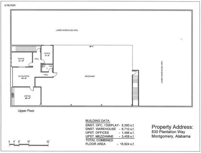
12,472 SF
DEMOGRAPHICS near 830 Plantation Way
1 Mile
3 Mile
5 Mile
2024 Total Population
5,351
33,210
96,372
2029 Population
5,161
32,152
93,360
Pop Growth 2024-2029
(3.55%)
(3.19%)
(3.13%)
Average Age
36
38
39
2024 Total Households
2,044
14,074
41,266
HH Growth 2024-2029
(3.52%)
(3.15%)
(3.25%)
Median Household Inc
$56,133
$55,665
$53,839
Avg Household Size
2.60
2.30
2.30
2024 Avg HH Vehicles
2.00
2.00
2.00
Median Home Value
$103,545
$144,375
$152,210
Median Year Built
1978
1979
1980
Nearby Places
- Restaurants
- Banks
- Shops
- Fitness
- Groceries
PUBLIC TRANSPORTATION
AIRPORT
Montgomery Regional (Dannelly Field)
DRIVE
WALK
Distance
Montgomery Regional (Dannelly Field)
22 min
16.1 mi
Freight Ports
Port of Panama City
DRIVE
WALK
Distance
Port of Panama City
237 min
187.8 mi
Nearby Properties
Address
Land Use
TOTAL SIZE
Lot Size
Zoning
Address
Land Use
TOTAL SIZE
Lot Size
Zoning
117,161 SF
12.07 AC
INST
Address
Land Use
TOTAL SIZE
Lot Size
Zoning
385,644 SF
26.60 AC
B-2
Address
Land Use
TOTAL SIZE
Lot Size
Zoning
31,205 SF
59 AC
INST
Address
Land Use
TOTAL SIZE
Lot Size
Zoning
92,200 SF
9.74 AC
O-1
Address
Land Use
TOTAL SIZE
Lot Size
Zoning
7,040 SF
11.70 AC
R-65-M
Address
Land Use
TOTAL SIZE
Lot Size
Zoning
24,360 SF
26.59 AC
R-65-M
Address
Land Use
TOTAL SIZE
Lot Size
Zoning
224,132 SF
26.57 AC
AGR-2
Address
Land Use
TOTAL SIZE
Lot Size
Zoning
223,000 SF
26 AC
O-1
Address
Land Use
TOTAL SIZE
Lot Size
Zoning
5,606 SF
21 AC
R-75-M
Address
Land Use
TOTAL SIZE
Lot Size
Zoning
591,904 SF
26 AC
M-1
Address
Land Use
TOTAL SIZE
Lot Size
Zoning
108,176 SF
4.27 AC
B-1-B
Address
Land Use
TOTAL SIZE
Lot Size
Zoning
154,375 SF
21.19 AC
B-3
Address
Land Use
TOTAL SIZE
Lot Size
Zoning
75,510 SF
10.97 AC
B-2
Address
Land Use
TOTAL SIZE
Lot Size
Zoning
82,638 SF
O-1
Address
Land Use
TOTAL SIZE
Lot Size
Zoning
65,394 SF
13 AC
B-2
Address
Land Use
TOTAL SIZE
Lot Size
Zoning
2,200 SF
11.06 AC
R-75-M
Address
Land Use
TOTAL SIZE
Lot Size
Zoning
6,024 SF
17.30 AC
R-75-M
Address
Land Use
TOTAL SIZE
Lot Size
Zoning
187,340 SF
22.80 AC
M-1
Address
Land Use
TOTAL SIZE
Lot Size
Zoning
11,190 SF
13.75 AC
AGR-1
Address
Land Use
TOTAL SIZE
Lot Size
Zoning
30,747 SF
21.58 AC
M-1
Address
Land Use
TOTAL SIZE
Lot Size
Zoning
88,034 SF
6.60 AC
M-1
Address
Land Use
TOTAL SIZE
Lot Size
Zoning
3,320 SF
11 AC
R-75-M
Address
Land Use
TOTAL SIZE
Lot Size
Zoning
67,643 SF
12.82 AC
M-1
Address
Land Use
TOTAL SIZE
Lot Size
Zoning
49,860 SF
4.10 AC
O-1
Address
Land Use
TOTAL SIZE
Lot Size
Zoning
8,014 SF
7.10 AC
R-75-M
Address
Land Use
TOTAL SIZE
Lot Size
Zoning
244,062 SF
12.94 AC
M-1
Address
Land Use
TOTAL SIZE
Lot Size
Zoning
64,237 SF
11.30 AC
INST
Address
Land Use
TOTAL SIZE
Lot Size
Zoning
18,557 SF
9.41 AC
R-75-S
Address
Land Use
TOTAL SIZE
Lot Size
Zoning
27,398 SF
10.61 AC
B-3
Address
Land Use
TOTAL SIZE
Lot Size
Zoning
18,439 SF
15 AC
B-3
The World's #1 Commercial Real Estate Marketplace
Connect with us
© 2025 CoStar Group
The information above has been obtained from sources believed reliable. While we do not doubt its accuracy we have not verified it and make no guarantee, warranty or representation about it. It is your responsibility to independently confirm its accuracy and completeness. Any projections, opinions, assumptions, or estimates used are for example only and do not represent the current or future performance of the property. The value of this transaction to you depends on tax and other factors which should be evaluated by your tax, financial, and legal advisors. You and your advisors should conduct a careful, independent investigation of the property to determine to your satisfaction the suitability of the property for your needs.