Property Record
209 E 3Rd St, Kimberly, WI 54136
This Property Is For Sale
NEARBY LISTINGS FOR SALE OR LEASE
-
-
View all Kimberly listings for sale on LoopNet.com
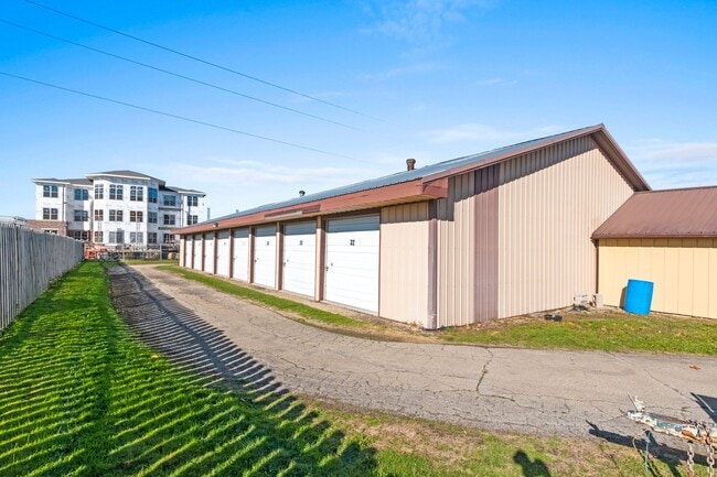
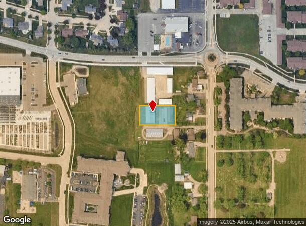
Property Detail
209 E 3Rd St
Appleton, WI
Certified Survey Map No 491
25-0-0950-26
CSM 491 OUTLOT 1 (PLATTED OUT OF PRT GOV LOT 7 SEC27-21-18) .48AC M/L
Commercialnec
Outagamie
X
Wisconsin
55087C0339D
1
2023
0.48 AC
2023
Outagamie County
011700
Green Bay
1,514 SF
DEMOGRAPHICS near 209 E 3Rd St
1 Mile
3 Mile
5 Mile
2024 Total Population
9,258
69,018
150,852
2029 Population
9,560
70,967
154,202
Pop Growth 2024-2029
+ 3.26%
+ 2.82%
+ 2.22%
Average Age
41
40
40
2024 Total Households
3,794
27,670
60,942
HH Growth 2024-2029
+ 3.24%
+ 3.01%
+ 2.30%
Median Household Inc
$79,014
$82,439
$81,104
Avg Household Size
2.40
2.40
2.40
2024 Avg HH Vehicles
2.00
2.00
2.00
Median Home Value
$251,885
$255,107
$254,481
Median Year Built
1990
1981
1978
Nearby Places
- Restaurants
- Banks
- Shops
- Fitness
- Groceries
PUBLIC TRANSPORTATION
AIRPORT
Appleton International
DRIVE
WALK
Distance
Appleton International
20 min
10.7 mi
Green Bay/Austin Straubel International
DRIVE
WALK
Distance
Green Bay/Austin Straubel International
33 min
24.0 mi
Freight Ports
Port Milwaukee
DRIVE
WALK
Distance
Port Milwaukee
130 min
112.0 mi
Nearby Properties
Address
Land Use
TOTAL SIZE
Lot Size
Zoning
Address
Land Use
TOTAL SIZE
Lot Size
Zoning
154,889 SF
1 AC
C2
Address
Land Use
TOTAL SIZE
Lot Size
Zoning
30.30 AC
Address
Land Use
TOTAL SIZE
Lot Size
Zoning
211,780 SF
23.01 AC
PDR3
Address
Land Use
TOTAL SIZE
Lot Size
Zoning
33.54 AC
Address
Land Use
TOTAL SIZE
Lot Size
Zoning
3.42 AC
PDC2
Address
Land Use
TOTAL SIZE
Lot Size
Zoning
309,785 SF
20.13 AC
R3
Address
Land Use
TOTAL SIZE
Lot Size
Zoning
84,620 SF
92.18 AC
C2
Address
Land Use
TOTAL SIZE
Lot Size
Zoning
20.37 AC
PDC2
Address
Land Use
TOTAL SIZE
Lot Size
Zoning
31.46 AC
Address
Land Use
TOTAL SIZE
Lot Size
Zoning
249,600 SF
11.88 AC
M1
Address
Land Use
TOTAL SIZE
Lot Size
Zoning
100,105 SF
12.62 AC
C2
Address
Land Use
TOTAL SIZE
Lot Size
Zoning
17.51 AC
Address
Land Use
TOTAL SIZE
Lot Size
Zoning
29,742 SF
5.95 AC
R3
Address
Land Use
TOTAL SIZE
Lot Size
Zoning
6.02 AC
Address
Land Use
TOTAL SIZE
Lot Size
Zoning
218,400 SF
12.39 AC
M1
Address
Land Use
TOTAL SIZE
Lot Size
Zoning
Address
Land Use
TOTAL SIZE
Lot Size
Zoning
247,520 SF
13.68 AC
M1
Address
Land Use
TOTAL SIZE
Lot Size
Zoning
37,430 SF
7.32 AC
M1
Address
Land Use
TOTAL SIZE
Lot Size
Zoning
12.49 AC
Address
Land Use
TOTAL SIZE
Lot Size
Zoning
Address
Land Use
TOTAL SIZE
Lot Size
Zoning
200,880 SF
14.60 AC
M1
Address
Land Use
TOTAL SIZE
Lot Size
Zoning
209,059 SF
18.40 AC
PDC2
Address
Land Use
TOTAL SIZE
Lot Size
Zoning
17.43 AC
M2
Address
Land Use
TOTAL SIZE
Lot Size
Zoning
Address
Land Use
TOTAL SIZE
Lot Size
Zoning
59,010 SF
13.09 AC
Address
Land Use
TOTAL SIZE
Lot Size
Zoning
5.10 AC
Address
Land Use
TOTAL SIZE
Lot Size
Zoning
45.88 AC
Address
Land Use
TOTAL SIZE
Lot Size
Zoning
108,328 SF
8.93 AC
R3
Address
Land Use
TOTAL SIZE
Lot Size
Zoning
20.22 AC
M1
Address
Land Use
TOTAL SIZE
Lot Size
Zoning
The World's #1 Commercial Real Estate Marketplace
Connect with us
© 2025 CoStar Group
The information above has been obtained from sources believed reliable. While we do not doubt its accuracy we have not verified it and make no guarantee, warranty or representation about it. It is your responsibility to independently confirm its accuracy and completeness. Any projections, opinions, assumptions, or estimates used are for example only and do not represent the current or future performance of the property. The value of this transaction to you depends on tax and other factors which should be evaluated by your tax, financial, and legal advisors. You and your advisors should conduct a careful, independent investigation of the property to determine to your satisfaction the suitability of the property for your needs.