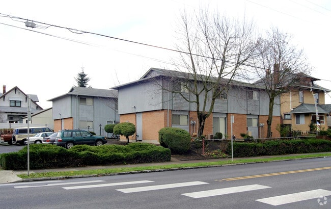
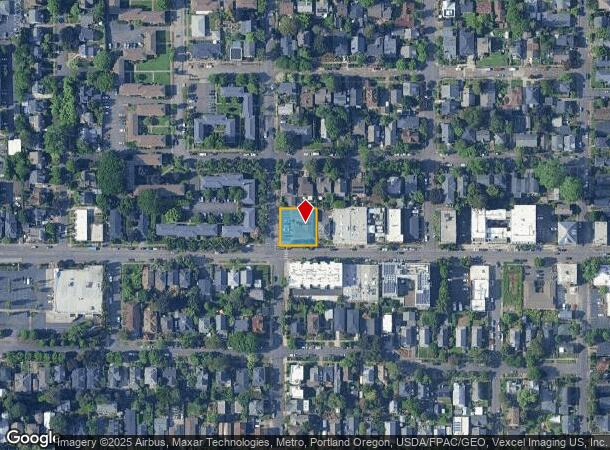
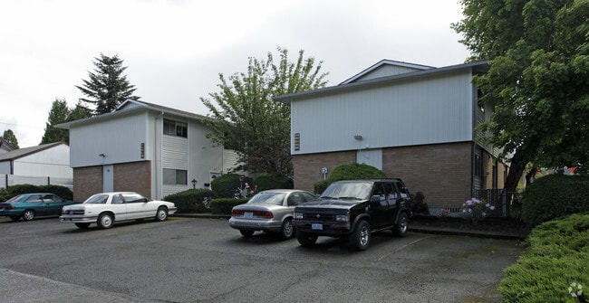
Property Record
830 Se 42Nd Ave, Portland, OR 97215

NEARBY LISTINGS FOR SALE OR LEASE
Property Detail
830 Se 42Nd Ave
Portland-Vancouver-Hillsboro, OR-WA
Clare Add
R134865
CLARE ADD, BLOCK 4, LOT 15&16
Multifamilydwelling
Multnomah
ARE
Oregon
53011C0525D
15,16
2025
0.23 AC
2025
Sunnyside
001400
Portland
6,776 SF
DEMOGRAPHICS near 830 Se 42Nd Ave
1 Mile
3 Mile
5 Mile
2024 Total Population
30,813
215,479
496,618
2029 Population
30,032
211,298
489,042
Pop Growth 2024-2029
(2.53%)
(1.94%)
(1.53%)
Average Age
40
40
40
2024 Total Households
14,070
98,793
222,422
HH Growth 2024-2029
(2.82%)
(1.98%)
(1.57%)
Median Household Inc
$98,118
$84,764
$81,046
Avg Household Size
2.10
2.10
2.10
2024 Avg HH Vehicles
1.00
1.00
1.00
Median Home Value
$714,088
$617,764
$554,092
Median Year Built
1948
1953
1961
Nearby Places
Map Layers
Map Styles
 Street
 Aerial
- Restaurants
- Banks
- Shops
- Fitness
- Groceries
PUBLIC TRANSPORTATION
COMMUTER RAIL
DRIVE
WALK
Distance
12 min
3.5 mi
AIRPORT
Portland International
DRIVE
WALK
Distance
Portland International
19 min
7.1 mi
Freight Ports
Port of Portland
DRIVE
WALK
Distance
Port of Portland
15 min
7.4 mi
SALE & LEASE HISTORY
LISTING DATE
SALE/LEASE

Jul 25, 2018
For Sale
Nearby Properties
Address
Land Use
TOTAL SIZE
Lot Size
Zoning
Address
Land Use
TOTAL SIZE
Lot Size
Zoning
627,500 SF
16.60 AC
CX
Address
Land Use
TOTAL SIZE
Lot Size
Zoning
822,867 SF
103.39 AC
CI1
Address
Land Use
TOTAL SIZE
Lot Size
Zoning
560,000 SF
0.15 AC
CX
Address
Land Use
TOTAL SIZE
Lot Size
Zoning
1.09 AC
EX
Address
Land Use
TOTAL SIZE
Lot Size
Zoning
2.24 AC
CX
Address
Land Use
TOTAL SIZE
Lot Size
Zoning
417,324 SF
0.68 AC
CX
Address
Land Use
TOTAL SIZE
Lot Size
Zoning
257,700 SF
2.89 AC
EX
Address
Land Use
TOTAL SIZE
Lot Size
Zoning
178,785 SF
10.20 AC
R5
Address
Land Use
TOTAL SIZE
Lot Size
Zoning
460,000 SF
0.92 AC
CX
Address
Land Use
TOTAL SIZE
Lot Size
Zoning
689,840 SF
0.92 AC
CX
Address
Land Use
TOTAL SIZE
Lot Size
Zoning
296,039 SF
11.70 AC
R5
Address
Land Use
TOTAL SIZE
Lot Size
Zoning
7.78 AC
EX
Address
Land Use
TOTAL SIZE
Lot Size
Zoning
183,664 SF
8.96 AC
R5
Address
Land Use
TOTAL SIZE
Lot Size
Zoning
584,483 SF
0.90 AC
CX
Address
Land Use
TOTAL SIZE
Lot Size
Zoning
280,069 SF
18.31 AC
IR
Address
Land Use
TOTAL SIZE
Lot Size
Zoning
247,520 SF
7.74 AC
CX
Address
Land Use
TOTAL SIZE
Lot Size
Zoning
306,000 SF
1.21 AC
NULL
Address
Land Use
TOTAL SIZE
Lot Size
Zoning
596,161 SF
0.92 AC
CX
Address
Land Use
TOTAL SIZE
Lot Size
Zoning
387,000 SF
0.88 AC
CXD
Address
Land Use
TOTAL SIZE
Lot Size
Zoning
473,746 SF
1.68 AC
Address
Land Use
TOTAL SIZE
Lot Size
Zoning
262,645 SF
1 AC
CX
Address
Land Use
TOTAL SIZE
Lot Size
Zoning
354,677 SF
0.79 AC
CX
Address
Land Use
TOTAL SIZE
Lot Size
Zoning
2,218,439 SF
21.88 AC
CX
Address
Land Use
TOTAL SIZE
Lot Size
Zoning
477,636 SF
0.90 AC
CXD
Address
Land Use
TOTAL SIZE
Lot Size
Zoning
191,724 SF
0.45 AC
CXD
Address
Land Use
TOTAL SIZE
Lot Size
Zoning
388,191 SF
1.86 AC
CX
Address
Land Use
TOTAL SIZE
Lot Size
Zoning
42,920 SF
1.16 AC
CX
Address
Land Use
TOTAL SIZE
Lot Size
Zoning
147,334 SF
10.92 AC
IG1
Address
Land Use
TOTAL SIZE
Lot Size
Zoning
297,636 SF
1.06 AC
CX
Address
Land Use
TOTAL SIZE
Lot Size
Zoning
360,053 SF
0.71 AC
EXD
The World's #1 Commercial Real Estate Marketplace
Connect with us
© 2026 CoStar Group
The information above has been obtained from sources believed reliable. While we do not doubt its accuracy we have not verified it and make no guarantee, warranty or representation about it. It is your responsibility to independently confirm its accuracy and completeness. Any projections, opinions, assumptions, or estimates used are for example only and do not represent the current or future performance of the property. The value of this transaction to you depends on tax and other factors which should be evaluated by your tax, financial, and legal advisors. You and your advisors should conduct a careful, independent investigation of the property to determine to your satisfaction the suitability of the property for your needs.