Property Record
830 Twining Rd, Dresher, PA 19025

Save to a Folder
{{folder.Name}}
{{folder.ListingIds.length}} Properties
{{folder.ListingIds.length}} Property
Create a New Folder
Property Detail
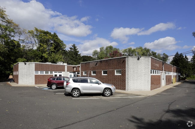
830 Twining Rd
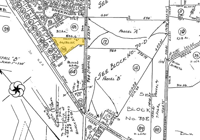
54-00-16161-003
L B 82 X IRR 66136 SF
Officebuilding
MONTGOMERY
CR
Pennsylvania
B and X Area of moderate flood hazard, usually the area between the limits of the 100-year and 500-year floods.
98
2026
1.52 AC
2026
Horsham/Willow Grove
201406
Philadelphia
8,508 SF
Philadelphia-Camden-Wilmington, PA-NJ-DE-MD
NEARBY LISTINGS FOR SALE OR LEASE
DEMOGRAPHICS near 830 Twining Rd
1 mile
3 mile
5 mile
2025 Total Population
8,319
92,491
257,485
2030 Population
8,472
94,229
260,897
Pop Growth 2025-2030
+ 1.84%
+ 1.88%
+ 1.33%
Average Age
41
41
43
2025 Total Households
2,956
34,383
102,158
HH Growth 2025-2030
+ 1.76%
+ 2.04%
+ 1.34%
Median Household Inc
$121,946
$111,261
$97,772
Avg Household Size
2.80
2.60
2.40
2025 Avg HH Vehicles
2.00
2.00
2.00
Median Home Value
$432,088
$425,126
$408,921
Median Year Built
1961
1958
1957
Nearby Places
Map Layers
Map Styles
 Street
 Aerial
Layers
 Traffic
 Biking
Places
Listings with unknown addresses are not visible on the map
- Restaurants
- Banks
- Shops
- Fitness
- Groceries
PUBLIC TRANSPORTATION
COMMUTER RAIL
Ardsley (R2 - Southeastern Pennsylvania Transportation Authority Regional Rail (SEPTA Regional Rail))
Drive
Walk
Distance
Ardsley (R2 - Southeastern Pennsylvania Transportation Authority Regional Rail (SEPTA Regional Rail))
4 min
1.5 mi
Oreland (R5 - Southeastern Pennsylvania Transportation Authority Regional Rail (SEPTA Regional Rail))
Drive
Walk
Distance
Oreland (R5 - Southeastern Pennsylvania Transportation Authority Regional Rail (SEPTA Regional Rail))
5 min
1.7 mi
AIRPORT
Philadelphia International
Drive
Walk
Distance
Philadelphia International
47 min
24.5 mi
Trenton Mercer
Drive
Walk
Distance
Trenton Mercer
45 min
29.5 mi
Freight Ports
Port of Philadelphia
Drive
Walk
Distance
Port of Philadelphia
25 min
13.5 mi
SALE & LEASE HISTORY
LISTING DATE
SALE/LEASE

Sep 21, 2022
For Sale
Nov 28, 2018
For Sale
Mar 05, 2020
For Sale
Jun 04, 2024
For Lease
Feb 04, 2019
For Lease
Feb 02, 2023
For Lease
Nearby Properties
Address
Land Use
TOTAL SIZE
Lot Size
Zoning
Address
Land Use
TOTAL SIZE
Lot Size
Zoning
1,556,628 SF
7.70 AC
AO
Address
Land Use
TOTAL SIZE
Lot Size
Zoning
794,476 SF
30.14 AC
PB
Address
Land Use
TOTAL SIZE
Lot Size
Zoning
733,282 SF
88.07 AC
LIM
Address
Land Use
TOTAL SIZE
Lot Size
Zoning
662,450 SF
55.03 AC
R1
Address
Land Use
TOTAL SIZE
Lot Size
Zoning
487,936 SF
58.50 AC
T
Address
Land Use
TOTAL SIZE
Lot Size
Zoning
678,360 SF
67.10 AC
LIM
Address
Land Use
TOTAL SIZE
Lot Size
Zoning
371,340 SF
53 AC
A
Address
Land Use
TOTAL SIZE
Lot Size
Zoning
467,639 SF
123.58 AC
IAAA
Address
Land Use
TOTAL SIZE
Lot Size
Zoning
335,203 SF
31.20 AC
C1
Address
Land Use
TOTAL SIZE
Lot Size
Zoning
334,265 SF
44.56 AC
INST
Address
Land Use
TOTAL SIZE
Lot Size
Zoning
752,716 SF
0.29 AC
OC
Address
Land Use
TOTAL SIZE
Lot Size
Zoning
239,971 SF
43.63 AC
AA
Address
Land Use
TOTAL SIZE
Lot Size
Zoning
498,072 SF
5.39 AC
TC1
Address
Land Use
TOTAL SIZE
Lot Size
Zoning
316,163 SF
45.32 AC
T
Address
Land Use
TOTAL SIZE
Lot Size
Zoning
456,997 SF
7.91 AC
INST
Address
Land Use
TOTAL SIZE
Lot Size
Zoning
222,235 SF
29.23 AC
A
Address
Land Use
TOTAL SIZE
Lot Size
Zoning
343,852 SF
8.42 AC
I
Address
Land Use
TOTAL SIZE
Lot Size
Zoning
242,560 SF
1.40 AC
OC
Address
Land Use
TOTAL SIZE
Lot Size
Zoning
336,650 SF
61.74 AC
R3
Address
Land Use
TOTAL SIZE
Lot Size
Zoning
435,888 SF
16.35 AC
MD
Address
Land Use
TOTAL SIZE
Lot Size
Zoning
167,743 SF
20.70 AC
T
Address
Land Use
TOTAL SIZE
Lot Size
Zoning
287,030 SF
106.42 AC
INST
Address
Land Use
TOTAL SIZE
Lot Size
Zoning
245,273 SF
32.49 AC
MD
Address
Land Use
TOTAL SIZE
Lot Size
Zoning
139,087 SF
2.76 AC
V
Address
Land Use
TOTAL SIZE
Lot Size
Zoning
206,934 SF
32.50 AC
NR
Address
Land Use
TOTAL SIZE
Lot Size
Zoning
264,219 SF
13.03 AC
TC1
Address
Land Use
TOTAL SIZE
Lot Size
Zoning
84,400 SF
4.70 AC
I
Address
Land Use
TOTAL SIZE
Lot Size
Zoning
236,808 SF
17.66 AC
PB
Address
Land Use
TOTAL SIZE
Lot Size
Zoning
309,264 SF
9.93 AC
I
Address
Land Use
TOTAL SIZE
Lot Size
Zoning
369,929 SF
16.45 AC
LIM
The World's #1 Commercial Real Estate Marketplace
Connect with us
© 2026 CoStar Group
The information above has been obtained from sources believed reliable. While we do not doubt its accuracy we have not verified it and make no guarantee, warranty or representation about it. It is your responsibility to independently confirm its accuracy and completeness. Any projections, opinions, assumptions, or estimates used are for example only and do not represent the current or future performance of the property. The value of this transaction to you depends on tax and other factors which should be evaluated by your tax, financial, and legal advisors. You and your advisors should conduct a careful, independent investigation of the property to determine to your satisfaction the suitability of the property for your needs.